“‘An Indian for breakfast and a pony to ride’ was their [105 men who volunteered under Major Ormsby after the killings at William’s Station] slogan as the command started across the wastes toward Pyramid Lake.”
Dorothy Mason, The Pony Express in Nevada,, p. 72
Camping
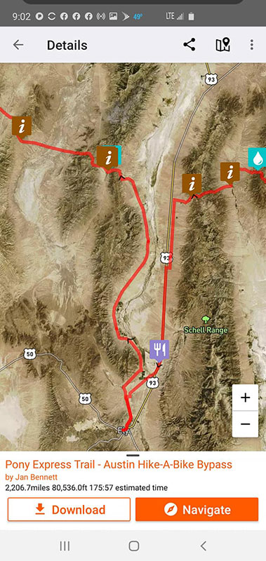
“From West of Casper, WY to outside of Sacramento, CA free camping on public lands can happen almost anywhere you can find a place to put your sleeping bag down. I wouldn’t necessarily suggest a hammock as there aren’t very many tall things to tie off to out in the high desert.
“In June of [1859] Captain Simpson, of the United States Topographical Engineers, surveyed a new route from Camp Floyd to Genoa, which it was claimed would shorten the distance about 300 miles. The distance from Camp Floyd, by the old Humboldt route to Genoa, was reported to be 854 miles, by the Chorpening route through Ruby Valley about 709 miles, and by the Simpson survey 565 miles.
In September the company cut hay and made the necessary preparations to move down on to the Central or Simpson route, which they did the winter following.”
Thompson and West, History of Nevada (1881), pg. 105
Jan Bennett Interview in Carson, NV
(from Jan Bennett’s interview video)
“Before the Burn in August we stayed over in Carson City for a few days. I had the opportunity to meet with Ben Spillman, a writer for the Reno Gazette Journal and the USA Today network. Ben was intrigued by my ride on the Pony Express and why I did it. He interviewed me on camera for a little bit. Here’s the result of that interview! I believe there’s an article coming out in a bit as well.”
Click here to view Jan’s video interview. The area Jan describes, Telegraph Pass, is in Nevada, near Corta Spring, north of Eureka, NV, at around mile 1732 to 1733. This is “right before the Thompson ranch on the west side of the range (water!!)” according to Jan.
“Beyond [Faust’s, or Rush Valley Station] was Point Lookout, which was the doorway to the worst desert on the North American Continent. Ahead lay a country of bare, rocky mountain ranges, limitless miles of parched sand, scant herbage, dust storms, shimmering mirages in summer and deadly cold in winter. It was a lonely land devoid of civilized habitations. Even wild animals seemed to shun it.”
Settle and Settle, Saddles and Spurs, p. 139
Mile 1478: Fish Springs
“At Fish Springs, whose water was filled with small, perch-like fish, two men had charge of the usual number of horses and mules. The water was warm and had a sulfurous taste, but those who lived there had become accustomed to it. Along the road for many miles past this place the ground was so thickly encrusted with alkali that it looked like snow.”
Settle and Settle, Saddles and Spurs, p. 140
Mile 1502: Willow Springs Station
“Early in June [1860] Elijah N. Wilson set out from Schell Creek to make his regular run to Deep Creek [Ibapah]. When he reached his destination he found that the rider who was to take the mochilla on was not there. Pushing on to Willow Spring he learned that the man had been killed on his run. Since his horse was worn out he had to, stop and let him rest a while.
“About four o’clock in the afternoon seven Indians rode in to demand that Peter Neece, the station keeper, give them something to eat. Neece offered them a twenty-four pound sack of flour, which was indignantly refused. They wanted a sack each instead. At that he tossed the flour back into the station and ordered them to clear out. He would give them nothing. This so angered them that as they passed the corral they filled an old, lame cow with arrows. Seeing this act of wanton cruelty Neece drew his revolver and killed two of them.
“Knowing that about thirty of them were camped not far off, and that an attack would almost certainly be made, they loaded all the empty guns they had and prepared to defend themselves. Just before dark they saw a cloud of dust in the distance which advertised the fact that the Indians were coming. Adopting the strategy of lying down upon the ground in the sagebrush they waited.
“Soon the Indians arrived and were greeted by gunfire from outside the station. This so confused them that they milled about in more or less confusion. Some of them attempted to return the fire by aiming at the gun flashes. This however, was not effective, for each time one of the defenders fired he instantly leaped to one side. Many years later Wilson said that although he had two revolvers he did little except jump from spot to spot. Finally he landed in a small ravine where he remained until the Indians rode off in disgust. When he joined his companions they praised him for his part in the affair but he would have none of it. Credit for the victory, he said, belonged entirely to them.”
Settle and Settle, Saddles and Spurs, p. 157
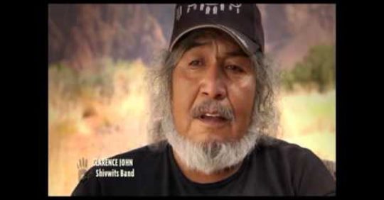
Mile 1530: Goshute Reservation
Still from video about Native American tribes of Utah
“While the Pony Express is seen as an achievement of the times from those who wrote history, there are stories of death and destruction that follow in its wake. The Pony Express, and numerous pioneer trails, crashed through what was once a peaceful, subsistance way of life for the people of the Goshute.
The route passes through the reservation lands of the Confederated Tribes of the Goshute Reservation, right after you pass through Ibapah, Utah, right before the Nevada border. The white man was not kind to these peaceful people. My time in this area of the route might be my most memorable. The land is vast, arid, rugid, and incredibly tranquil. Many times I found myself considering what might have been different those before us had saught out a more peaceful way to exist along side people who had been here for centuries before.
This hour long video covers the 5 Native American tribes of Utah as they currently stand. The video starts at the Goshute, but I would highly suggest going back to the beginning, grabbing a cup of coffee, and settling in for a quick history lesson. That these people found a way to thrive is worthy of more recognition than I fear they will ever recieve.”
Just before Mile 1544, Pleasant Valley Road splits off the XP Route (Hwy 2/White Pine County Road 32) to the south. Shortly after, it crosses a jeep trail (marked on the US Topo Scans and ESRI views) that leads past an XP Marker off the XP Route. By following this route, and a later detour off the route, this road leads to the Tippet Ranch, where there is water available. This is roughly a 10-mile variation on the official route.
Mile 1544: Route Alternate
Mile 1557: Route Alternate
According to one source (William Hill, p. 214), the road over Rock Springs Pass was a summer shortcut. Winters, the route ran around the south of the Antelope Mountains. According to Richard Burton (quoted in Hill, p. 213), “Beyond Antelope Springs was Shell Creek, distant thirty miles by long road and eighteen by short cut.”
A detour along this route would continue southeast on White Pine County Road 32 to Twelvemile Summit, then turn northwest over Tippett Pass on White Pine County Road 34 to Hwy 893 (White Pine County Road 31) and rejoin the route at the site of Spring Valley Station.
Note: water is marked as available at Rock Springs on the summer route. No water sources are marked on the alternate.
William E. Hill, The Pony Express Trail: Yesterday and Today, p. 214
Mile 1565: Rock Springs
“Another station, Rock Springs was added on the shortcut or summer express route. It cut over the southern tip of the Antelope Mountains with the intent of reducing distance and time. Nothing remains of Rock Springs or Spring Valley Station.”
William E. Hill, The Pony Express Trail: Yesterday and Today, p. 214
Mile 1573: Spring Valley Station
“The keeper of . . . Spring Valley was Constant Dubail, a Frenchman. It was here that Elijah N. Wilson was wounded in the head by an arrow. . . .
“In September [1860] Elijah N. Wilson was sent along the line from Schell Creek to Antelope station with a number of horses. He made the trip safely, delivered his charges, and started back the next day. When he reached Spring Valley station he found two young men who invited him to stay for dinner.
“Wilson accepted the invitation and turned his horse loose, thinking it would go to the stable in the corral. Instead it joined some others which were grazing behind the station. A short time later they saw Indians driving all of the horses across a meadow toward a cedar grove a short distance away. They ran after the thieves on foot, but the animals entered the trees before they could be overtaken. As he ran, Wilson fired his revolver, but without effect. Having outdistanced his companions he entered the cedars ahead of them.
“As he ran around a large one, an arrow struck him in the forehead about two inches above the left eye and lodged there. He fell to the ground unconscious. The young men came up and did what they could for him. When they tried to pull the arrow out the shaft came loose leaving the point stuck in his forehead. The Indians got away with all the horses.
“Being certain Wilson would die the young men rolled him into the shade of the cedar and set out for the next station on foot. On the following day they came back with some men to bury him. Finding him still alive they carried him into the station and a messenger was sent to Ruby Valley, a full days ride each way, for a doctor. Upon his arrival he removed the arrow point but there was little else he could do. He cold the young men to keep a wet rag on the wound and went back. For six days Wilson lay fighting for his life with only such rude nursing as his friends could give him.
“No doubt he would have died had not Howard Egan come along, possibly on his way back to Sale Lake City. The Division Superintendent took one look at him, then sent a rider post haste to Ruby Valley to bring the doctor back. For twelve days longer Wilson lay in a stupor, hovering between life and death. Then to everyone’s delight he began to mend. In a short time he was able to ride again. The wound left such an unsightly scar upon his forehead chat ever after he wore his hat outdoors and indoors to hide it.”
[Note: The Pony Express National Historical Study, and all reports based on it, state that Elijah N. “Uncle Nick” Wilson died as a result of his wound.]
Settle and Settle, Saddles and Spurs, p. 141, 158-159
Mile 1578: Schellbourne Rest Stop
“I would very strongly caution against assuming that highway rest stops out here will have any supplies. This stretch of the route passes through some of the most remote lands in the world. Still. To this day.
The Schelborne rest stop is nothing more than a large parking lot to house vehicles and tractor-trailers during foul weather. The only facilities here are composting toilets, like what you find in national parks. There is no water and there are no vending machines.
There is no shelter other than those toilets, which will be in demand at all hours due to the distances between towns along that highway.
There is signage talking about the Pony Express through the area though. It’s worth stopping to read it!
Across the highway, if you are using Google maps, you will notice Schellbourne Station. It is an abandoned gas station/restaurant/motel. All of the doors are gone, windows are busted out, and rooms are littered with squatters trash. Simply put, you cannot rely on this rest area for anything other than hitching a ride into town and a toilet.
Behind the Schellbourne station there used to be a RV park. It is overgrown and there is very little good space to sleep. It is also right along the highway and is loud at night (ask me how I know! hehe).”
Just past Mile 1588, the Pony Express trail veers to the right from the road. The Pony Express Bikehiking Trail map deviates from the original route. This adds approximately 60 miles to the route. Following is Jan’s explanation:
“This is an area of the route that I struggled with a great deal. It also proved to be quite an experience to bikepack it solo!
Once you leave Salt Lake City there is no food resupply directly along the route until you hit Austin, NV, nearly 400 miles away. While I was at the Bikepacking Summit in Gunnison, CO a few years ago I ran this section by a number of exceptionally experienced bikepackers and the consensus was to simply make it a part of the route. If folks wanted to bypass it, that was up to them. Because of the remoteness of this section all felt that it was prudent to direct folks to resupply and let them make the decisions themselves if they wanted to continue along the original route instead.
Simply put, if you are of the opinion that you can haul enough food to make it 400 miles across the desert then these route deviations are not necessary. Your daily mileage and comfort level will dictate this. I would encourage you to take into consideration your daily mileages on a fully loaded bike, at elevation, in an extremely arid environment. Especially in the middle of the summer. I definitely don’t want to sound alarmist, but this area of the country is not an area to take lightly.”
“Now comes the 2,000 foot climb up and over Rock Springs Pass, the highest point along the entire Pony Express Trail, higher even than South Pass in the Rockies, or Carson Pass in the Sierra Nevada. As we climb, and along for a distance, comes the original Lincoln Highway of 1913. When the climb turn steep, the old highway (and the Overland Stage) turns away to skirt the mountain to the south. By two we’re standing in the pass. What a long, uphill pull. It’s hard to imagine how the pony riders managed to climb some of these unbelievable boulder-strewn canyons—let alone, make good time!
“A short downhill and we arrive Rock Springs, a fine little babbling brook that emerges from a rock outcrop just above. We take of the cold, clear water.”
“Special recognition is given to this canyon simply because it is given so much notice by the literature. Egan Canyon was named for Howard Egan who pioneered Chorpenning’s mail service through there in the l850’s.
When Simpson passed through the canyon on May 15, 1859 he was impressed by its ruggedness.
Egan Canyon we found quite narrow, and somewhat remarkable on account of the rocks which wall it in on either side. These rocks are tremendously massive, and rise sheer to a height in one place of about 1,000 feet.
Egan Canyon was the site of many ambushes by the Indians since it was an ideal location. . . .
“Today a good county road criss crosses the creek as it runs up the canyon. Despite the absence of threatening Indians, if you travel the canyon at dusk, the rock cliffs and high walls arouse the same awesome, closed-in feeling today as they did when Simpson, Burton and all the Pony` Express riders passed through them.”
Dorothy Mason, The Pony Express in Nevada,, p. 62
Mile 1678: Egan's Station
“In the early part of October [1860] a war party of eighty Pah Utes descended upon Egan’s station while Mike Holt station keeper, and a rider by the name of Wilson were at breakfast. Leaping to their feet they grabbed their guns and began firing upon them. The Indians had no guns, but filled with confidence of victory due to overwhelming numbers, they swooped in for the kill. Holton and Wiison fought heroically and kept them at bay until their ammunition was exhausted. Then, as the Indians broke through the door they heard the chief utter the one word ‘bread.’
“Hoping to satisfy them, and thus escape death, the white men piled all the bread in the station on the table. To their dismay the chief remained unsatisfied. Pointing to the sacks of flour piled in one corner he ordered them to build a fire and bake more. Throughout the day Holton and Wilson continued to supply bread to their ravenous, unwelcome guests. As they worked they talked about William Dennis, rider from the west who was due to arrive late in the afternoon. When he did not come they concluded the Indians had killed him.
“About sundown, the stock of flour having been exhausted, the chief ordered Holton and Wilson taken outside and tied to a wagon tongue which had been driven into the ground. Having done this they proceeded to pile sage brush at their feet with the expectation of roasting them alive. Then, they set it afire and began to dance and yell like demons.
“But the Indians had not gotten Dennis. As he approached the station he saw the savages from the distance, whirled his horse around, and raced back the way he had come. They were so busy celebrating the torture of Holton and Wilson they did not see him. About five miles back he had passed Lieutenant Weed and sixty United States dragoons on their way east to Salt Lake City. Upon being informed of what was going on at the station they swept ahead full tilt, roared down upon the scene, and caught the merrymaking savages by surprise in time to prevent injury to the captives. When it was over the Indians had lost eighteen warriors and sixty horses.”
[Note: Other sources give the date of this event as July 15 or 16, 1860. See, e.g., Historic Resource Study, p. 183-84; Burton (p. 169) gives the date as August]
Settle and Settle, Saddles and Spurs, p. 159-160
Mile 1678: Egan’s Station
“The rider carrying the August 1 westbound mail just missed an Indian attack on Egan Canyon station, which turned into a fierce battle between the Indians and the U.S. mounted cavalry commanded by Lieut. Weed. This battle occurred on August 11, based on the journal kept by Private Scott and, more definitively, the official report from Lieut. Weed dated August 12, 1860 (U.S. Senate Documents).
Lieut. Weed’s report and Private Scott’s journal entry agree on the basic facts. On August 11, shortly before 5 p.m., Lieut. Weed led three non-commissioned officers and 24 privates east from their depot in Ruby Valley toward Antelope Springs on a mission to “chastise certain Indians in that vicinity for depredations recently committed,” according to Lieut. Weed. A short distance before reaching Egan Canyon Station, a Pony Express rider heading east passed Lieut. Weed’s slow-moving convoy. As the rider approached Egan Canyon Station, he saw a large group of armed Indians surrounding the station and engaging in hostile acts. The rider turned around and quickly rode west to alert Lieut. Weed of the attack.
Leaving a non-commissioned officer with seven men to guard the two wagons, Lieut. Weed and 20 mounted cavalrymen galloped toward Egan Canyon Station. There they encountered 75 to 100 Indians around the station and a somewhat larger number 500 to 800 yards away in the surrounding mountains. The Indians had taken the station’s supplies and were holding the station keeper and another man captive. Lieut. Weed ordered his men to surround the Indians near the station, but before the soldiers could completely encircle them, two or three soldiers “fired prematurely, thus alerting the Indians, and leaving an opportunity for them to retreat…”
A firefight ensued, but the Indians were able to work their way up the sides of the mountains south and east of the station, where they were protected from the soldiers’ fire. Faced with the Indians’ superior position, Lieut. Weed ordered his men to withdraw from the pursuit, allowing the Indians to flee. Three of Lieut. Weed’s men were wounded, one of whom died two days later. One Indian was killed and four wounded. Lieut. Weed reported that two other Indians had fallen—mortally wounded, according to him—but they had been picked up and carried away.”
“While the Shoshonee is tracking and driving the old mare, we will glance around the “Robber’s Roost,” which will answer for a study of the Western man’s home.
It is about as civilized as the Galway shanty, or the normal dwelling-place in Central Equatorial Africa. A cabin fronting east and west, long walls thirty feet, with port-holes for windows, short ditto fifteen; material, sandstone and bog ironstone slabs compacted with mud, the whole roofed with split cedar trunks, reposing on horizontals which rested on perpendiculars. Behind the house a corral of rails planted in the ground ; the inclosed space a mass of earth, and a mere shed in one corner the only shelter. Outside the door the hingeless and lockless backboard of a wagon, bearing the wounds of bullets and resting on lintels and staples, which also had formed parts of locomotives, a slab acting stepping-stone over a mass of soppy black soil strewed with ashes, gobs of meat offals, and other delicacies. On the right hand a load of wood; on the left a tank formed by damming a dirty pool which had flowed through a corral behind the “Roost.” There was a regular line of drip distilling from the caked and hollowed snow which toppled from the thick thatch above the cedar braces.
The inside reflected the outside. The length was divided by two perpendiculars, the southernmost of which, assisted by a halfway canvas partition, cut the hut into unequal parts. Behind it were two bunks for four men : standing bedsteads of poles planted in the ground, as in Australia and Unyamwezi, and covered with piles of ragged blankets. Beneath the frame-work were heaps of rubbish, saddles, cloths, harness, and straps, sacks of wheat, oats, meal, and potatoes, defended from the ground by underlying logs, and dogs nestled where they found room. The floor, which also frequently represented bedstead, was rough, uneven earth, neither tamped nor swept, and the fine end of a spring oozing through the western wall kept part of it in a state of eternal mud. A redeeming point was the fireplace, which occupied half of the northern short wall: it might have belonged to Guy of Warwick’s great hall; its ingle nooks boasted dimensions which one connects with an idea of hospitality and jollity; while a long hook hanging down it spoke of the bouillon-pot, and the iron oven of hot rolls. Nothing could be more simple than the furniture. The chairs were either posts mounted on four legs spread out for a base, or three-legged stools with reniform seats. The tables were rough-dressed planks, two feet by two, on rickety trestles. One stood in the centre for feeding purposes; the other was placed as buffet in the corner near the fire, with eating apparatus tin coffee-pot and gamelles, rough knives, “pitchforks,” and pewter spoons. The walls were pegged to support spurs and pistols, whips, gloves, and leggins. Over the door, in a niche, stood a broken coffee-mill, for which a flat stone did duty. Near the entrance, on a broad shelf raised about a foot from the ground, lay a tin skillet and its “dipper.” Soap was supplied by a handful of gravel, and evaporation was expected to act towel. Under the board was a pail of water with a floating can, which enabled the inmates to supply the drainage of everlasting chaws. There was no sign of Bible, Shakspeare, or Milton; a Holywell-Street romance or two was the only attempt at literature. En revanche, weapons of the flesh, rifles, guns, and pistols, lay and hung all about the house, carelessly stowed as usual, and tools were not wanting hammers, large borers, axe, saw, and chisel.”
Richard Burton, The City of Saints, p. 469-70
Mile 1707: Mountain Springs Station
“This station is very well signed, very easy to find and see.” Note that this is a short distance off the Pony Express route. Jan reports a cattle trough at the site of Mountain Springs.
“Ruby Valley is a half-way house, about 300 miles from Great Salt Lake City, and at the same distance from Carson Valley. It derives its name from the small precious stones which are found like nuggets of gold in the crevices of primitive rock. . . .
“We were received at the Ruby-Valley Station by Colonel Rogers, better known as ‘Uncle Billy.’ He had served in the troublous days of California as marshal, and has many a hairbreadth escape to relate.”
Note: The location on the XP route map seems to be off. Proper link (according to Expedition Utah and as noted in the POI on the XP Route map) is https://goo.gl/maps/x3zLsuKguS4LQAqaA.
Richard Burton, The City of Saints, p. 471
Mile 1732: Jacob's Well Station
“Today nothing remains but a few old stones from which the old well has long since caved in with rock and dirt. It was not only was a change station for the Pony Express until its demise as well as the Overland Stage Line until 1869, but it later served the Hill Beachy Road to Hamilton and the White Pine Mines.”
Posted on the Pony Express National Trail Facebook page:
“You may not be able to get out on the Pony Express, so we will bring it to you! Read along to take a virtual visit to five historic station sites across 53 miles.
(Photo/NPS/Exhibit from Garden Pass/Click the link for an accessible pdf version of the full exhibit).”
Comments give more information about access to the mining area where Sulphur Springs Station is located. Note that this station is off the Pony Express Bikepacking Route if you take the detour at Mile 1735 to restock at Eureka.
Just before Mile 1738, the Pony Express trail veers to the right from the road. The Pony Express Bikehiking Trail map deviates from the original route. This adds approximately 35 miles to the route. Following is Jan’s explanation:
“The pass that you will cross before Eureka is difficult. Do not underestimate the time it will take for you to make it to the top, and then the technical nature of the descent on the back side.
[And to reiterate]
Once you leave Salt Lake City there is no food resupply directly along the route until you hit Austin, NV, nearly 400 miles away.
While I was at the Bikepacking Summit in Gunnison, CO a few years ago I ran this section by a number of exceptionally experienced bikepackers and the consensus was to simply make it a part of the route. If folks wanted to bypass it, that was up to them. Because of the remoteness of this section all felt that it was prudent to direct folks to resupply and let them make the decisions themselves if they wanted to continue along the original route instead.
Also, please note that the stations that are marked are historical stations. They are not manned stations in any way. There are no supplies available. Many times all you will find is a marker and some ruins. Little more.
Simply put, if you are of the opinion that you can haul enough food to make it 400 miles across the desert then these route deviations are not necessary. Your daily mileage and comfort level will dictate this.
I would encourage you to take into consideration your daily mileages on a fully loaded bike, at elevation, in an extremely arid environment. Especially in the middle of the summer. I definitely don’t want to sound alarmist, but this area of the country is not an area to take lightly.
The station site and the Pony Express Monument are in separate locations.
The site is at https://goo.gl/maps/6ecT5eFvKsvLdtXM9. In satellite view, it appears there is a cutoff from the XP Trail just before the trail turns south to Thompson Ranch (at the west end of Telegraph canyon).
According to the US Topo map, the monument is located by the Thompson Ranch approximately at the POI water icon. (“There is a brass Pony Express centennial plaque mounted in a stone and concrete monument near the ranch house just one mile south of the actual station site.”)
One author (Hill, p.222) states (without citation) that Diamond Springs served as a gathering place during the Pauite War.
“We hastened to ascend Chokop’s Pass by a bad, steep dugway: it lies south of ” Railroad Kanyon,” which is said to be nearly flat-soled. A descent led into ‘Moonshine,’ called by the Yutas Pahannap Valley, and we saw with pleasure the bench rising at the foot of the pass. The station is named Diamond Springs, from an eye of warm, but sweet and beautifully clear water bubbling up from the earth. A little below it drains off in a deep rushy ditch, with a gravel bottom, containing equal parts of comminuted shells: we found it an agreeable and opportune bath.”
Richard Burton, The City of Saints, p. 480
Mile 1792: Sulphur Springs Station
“Sulphur Springs is commonly listed as a Pony Express Station. However, it could not have been one of the original stations built in the spring of 1860. In reviewing the literature, there is no mention of this station prior to the Overland Stage and Mail Express maps of 1863. Sulphur Springs was probably built in July of 1861 to facilitate the opening of the Overland Stage. Since it was on, or at least near, the Pony Express Route it was probably used as a way station for horse changes from the time of the station’s inception to the demise of the Pony. It was used as an Overland stop until 1869.
“At Sulphur Springs, which is now fenced in, and across the road there are several types of ruins. There is one remnant of a log wall, several stone foundations, and many pieces of old artifacts. This is possibly the site of the Overland Stage Station. The site is 1-2 miles N of the Pony Express Trail and about 2 miles S of the Sulphur Springs Ranch which has since been renamed the Diamond Star Ranch. The site is on private land owned by John Trowbridge.”
At the Pony Express Monument marked on the XP Route map just past Mile 1794, there are two possible routes.
The first turns southwest and heads more or less straight to Robert’s Station. The distance is about 10 miles. This is the route followed by the official XP Bikepacking Route and marked on the BLM route of the Pony Express Trail (around Mile 67–https://ridewithgps.com/routes/34091538). This is the route the Simpson Expedition took (Jesse G. Petersen, A Route for the Overland Stage, p. 61).
Jan’s “True as accessible” route at Mile 1676 (https://ridewithgps.com/routes/34516845?privacy_code=ESM1W5E3dAJJhaEI) continues straight at this point (northwest on Highway 278 through Garden Pass Canyon) to go north over Mt. Hope before turning southwest to Robert’s Station. This route is 14 miles, and seems to include more climbs than the southern route. It also may offer access to numerous springs, as yet unscouted. This route is marked on the US Topo map as the Pony Express Route.
If Burton’s mileage estimates are reasonably accurate, the historical route seems to go north around Mt. Hope.
Cross Moonshine [Diamond] Valley. After 7 miles a sulphurous spring and grass [future site of Sulphur Springs Station?]. Twelve miles beyond ascend the divide [Sulphur Springs Ridge, according to Peterson]; no water; fuel and bunch-grass plentiful. Then a long divide. After 9 miles, the station on Roberts’ Creek, at the E. end of Sheawit, or Roberts’ Springs Valley [Kobeh Valley]. 28 Miles
Richard Burton, The City of Saints, p. 512
Lexicon: “Simpson indicated that the natives of the area called the stream She-o-wi-te, which he understood to mean Willow Creek, and that is what he decided to call the stream.” It later came to be known as Roberts Creek, after Bolivar Roberts (Jesse G. Petersen, A Route for the Overland Stage, p. 62).
Mile 1795: Route Alternate
Mile 1804: Robert's Creek
“A long divide, with many ascents and descents, at length placed in front of us a view of the normal ‘distance’—heaps of hills, white as bridal cakes, and, nearer, a sand-like plain, somewhat more yellow than the average of those salt-bottoms: instinct told us that there lay the station-house. From the hills rose the smokes of Indian fires : the lands belong to the Tusawichya, or White-Knives, a band of the Shoshonees under an independent chief. This depression is known to the Yutas as Sheawit, or Willow Creek: the whites call it, from Mr. Bolivar Roberts, the Western agent, ‘Roberts’ Springs Valley.’ It lies 286 miles from Camp Floyd: from this point ‘Simpson’s Eoad’ strikes off to the S.E., and as Mr. Howard Egan’s rule here terminates, it is considered the latter end of Mormondom. Like all the stations to the westward, that is to say, those now before us, it was burned down in the late Indian troubles, and has only been partially rebuilt.”
Richard Burton, The City of Saints, p. 481
Mile 1804: Roberts Creek Station
“On May 31 [1860], C. H. Ruffin, a Pony Express employee, wrote William W. Finney in San Francisco that he and others had been driven out of Cold Creek Station by an Indian attack on the night of May 29. He also said that the men at Dry Creek had been killed, and it was thought that Roberts Creek Station had been destroyed. Both of these reports were correct.”
Turning south to US 50 and following Simpson’s route around Cape Horn Station (of the Overland Stagecoach).
Mile 1834: Route Alternatives
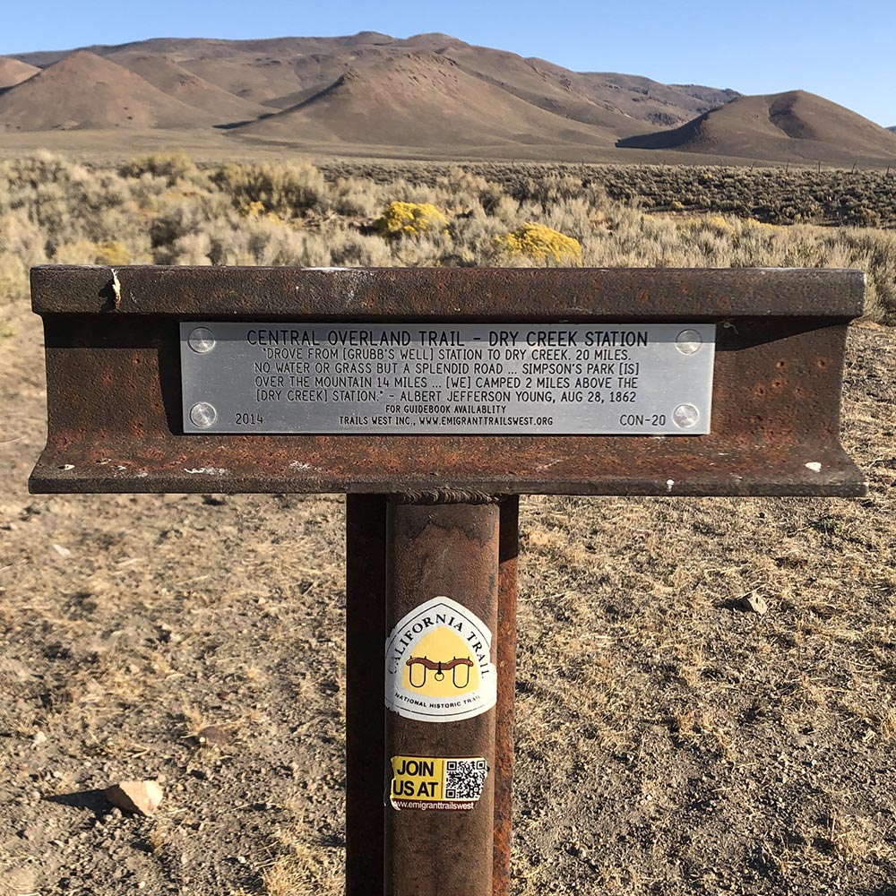
Mile 1835: Dry Creek
“Twenty miles farther led to the west end of the Sheawit Valley, where we found the station on a grassy bench at the foot of low rolling hills. It was a mere shell, with a substantial stone corral behind, and the inmates were speculating upon the possibility of roofing themselves in before the winter. Water is found in tolerable quantities below the station, but the place deserved its name, ‘Dry Creek.’ . . .
“Dry-Creek Station is on the eastern frontier of the western agency; as at Roberts’ Creek, supplies and literature from Great Salt City east and Carson City west are usually exhausted before they reach these final points. After a frugal feed, we inspected a grave for two, which bore the names of Loscier and Applegate, and the date 21st of May. These men, employes of the station, were attacked by Indians Panaks or Shoshonees, or possibly both: the former was killed by the first fire; the latter, when shot in the groin, and unable to proceed, borrowed, under pretext of defense, a revolver, bade good-by to his companions, and put a bullet through his own head: the remainder then escaped. Both these poor fellows remain unavenged. The Anglo-American, who is admirably protected by the officials of his government in Europe, Asia, and Africa, is systematically neglected—teste [witness, for example] Mexico—in America. The double grave, piled up with stones, showed gaps where the wolves had attempted to tunnel, and blue-bottle flies were buzzing over it in expectation. Colonel Totten, at our instance, promised that it should be looked to. . . .
“Shortly after 8 A.M. we were afield, hastening to finish the long divide that separates Roberts’ Creek Valley from its western neighbor, which, as yet unchristened, is known to the b’hoys as Smoky Valley. The road wound in the shape of the letter U round the impassable part of the ridge [i.e., via the Cape Horn route south of Simpson Mountains rather than over Eagle Butte, which is the Pony Express rote]. Crossing the north end of Smoky Valley, we came upon rolling ground, with water-willows and cedars ‘blazed’—barked with a gash—for sign-posts.”
Richard Burton, The City of Saints, p. 483-484
Mile 1835: Dry Creek
“[W]hen Streeper was ready to return, two prospectors traveling toward Salt Lake City, asked him if they could accompany him, to which he replied that they could if they were not afraid of Indians. They fared forth and saw no Indians or anything else out of the ordinary until they neared Dry Creek station. They saw no signs of anyone about and a herd of cattle was moving away from it.
Riding on in Streeper dismounted, walked to the door of the station and looked inside. Years later he said that what he saw caused his hair to stand on end. Before him lay the scalped, mutilated body of Ralph Rosier, the station keeper. John Applegate and Lafayette (“Bolly”) Bolwinkle were not there. Later, he learned what had happened.
A day or so before, after he had passed on his westward way, Rosier and Applegate rose early as usual to begin the days work. ‘Bolly’ was enjoying an extra forty winks before joining them. Applegate started to make a fire to get breakfast while Rosier went to the spring for a bucket of water.
Suddenly a rifle shot rang out and Rosier screamed. Applegate leaped to the door, looked out, saw his friend upon the ground dying, and turned back. Another shot, and Applegate fell to the floor, a horrible wound in his hip and groin. A moment later McCandless who was alone in his trading post, dashed across the road and took refuge in the station.
‘Bolly’ leaped from his bed in his stocking feet, and seized his gun. For some minutes he and McCandless worked like beaver piling grain bags in the doorway and making other preparations to defend the place to the last ditch. Applegate, who was suffering intensely, urged them to abandon him to his fate and attempt to reach the next station. When they refused he asked for a revolver. They gave him one, thinking he wished to take a shot at an Indian. Instead he shot himself through the head.
After the first two shots the attackers seem to have remained quiet, for nothing is said about ‘Bolly’ and McCandless having fought them. At length the trader declared they had to make a run of it to the next station. When ‘Bolly’ objected on the grounds that the Indians would certainly cut them down in the open, McCandles assured him such was not the case. They were not after him, he said, and since he had always treated them well they had a friendly feeling for him. If ‘Bolly’ would stay close to him they would nut dare shoot for fear of hitting him.
‘Bolly’ at length agreed co make the attempt. When everything was ready, the grain bags were removed from the door and they leaped outside. As they dashed down the road McCandless kept between ‘Bolly’ and the Indians. A few gave chase on foot, but the fugitives outdistanced them. Being satisfied with the blood they had already shed, they turned hack to loot the station.
‘Bolly’ and McCandless reached the next station in safety where they found three or four men ready to defend it. Having covered the ten or twelve miles without boots ‘Bolly’s’ feet were so cut by stones and filled with cactus thorns that he was laid up for some time.”
Settle and Settle, Saddles and Spurs, p. 155-156
Mile 1835: Dry Creek Monuments
Pony Express plaque
There are two monuments near the site of Dry Creek Station:
In addition, various authors state that there are station ruins and a gravestone nearby. I wasn’t able to find them on my scouting trip, but maybe it just takes a little more effort:
“The building ruins are overgrown by sagebrush. The grave of Applegate and Roiser is on the crest of the hill nearby.”
Hill, The Pony Express Trail: Yesterday and Today, p. 224.
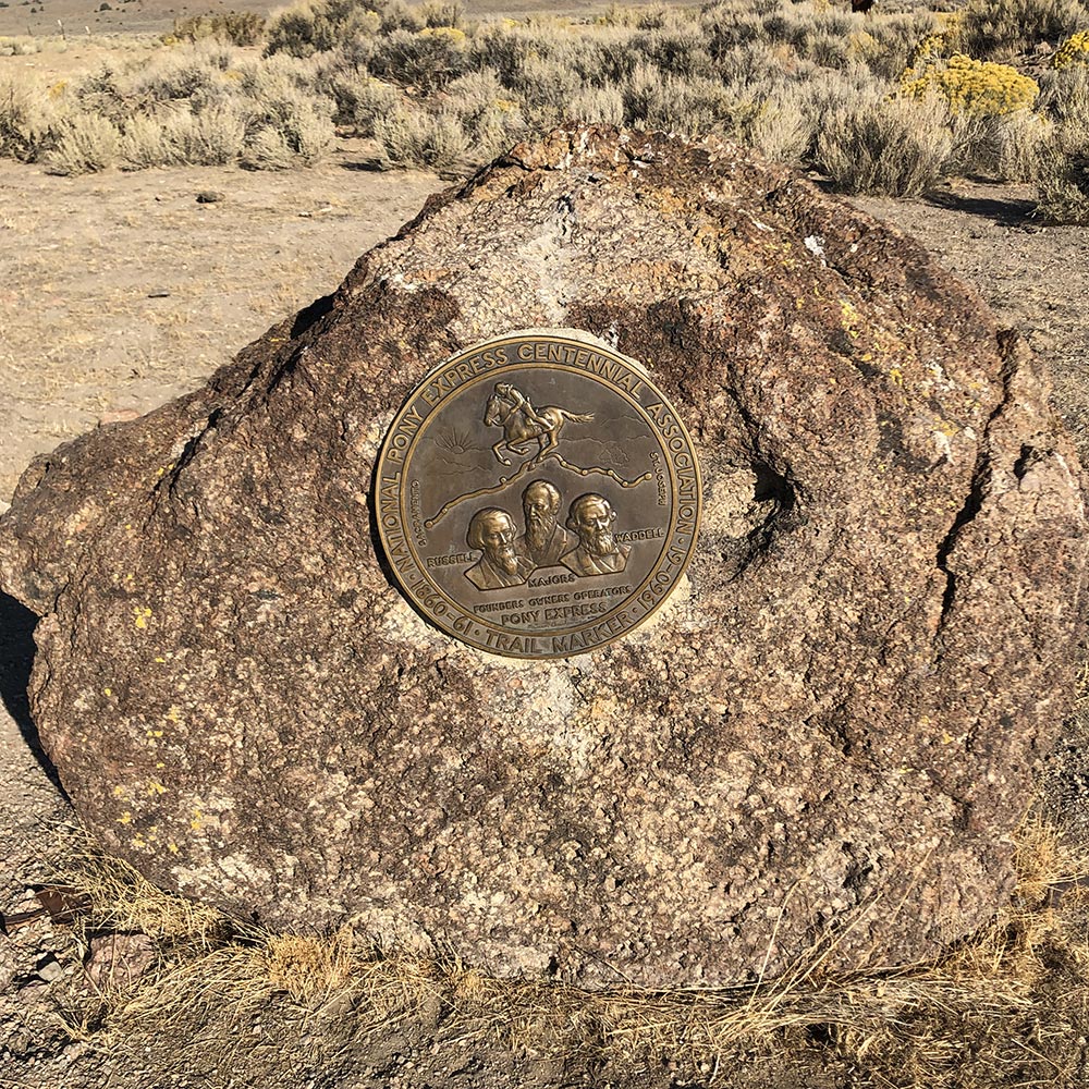
Central Overland Trail marker
A few rock foundations, overgrown with sagebrush, mark the mound above the creek where the station was situated. A rock monument built by the Damele’s in 1960 bearing a brass commemorative plate, distributed as part of the Pony Express Centennial in 1960, sits near the station site. . . . Remains of the Overland Stage Station, a stone structure, sit just off the main gravel road before it turns to go up to the ranch.
“A second divide, more abrupt than the former, placed us in sight of Simpson’s Park and such a park! a circlet of tawny stubble, embosomed in sage-grown hills, the ‘Hiré’ or ‘Look-out,’ and others, without other tree but the deformed cedars. The bottom is notorious for cold; it freezes even in June and July; and our night was, as may be imagined, none of the pleasantest. . . .
“Simpson’s Park lies 195 miles from Carson City, where we might consider the journey at an end; yet the cold of night did not allow us to set out before 10 A.M. Our route lay across the park, which was dotted with wheat-grass and broom-like reeds rising from a ground saupoudré like salt. Presently we began to ascend Simpson’s Pass, a long kanyon whose sloping sides and benches were dotted with the green bunch-grass. At the divide we found the ‘Sage Springs,’ whose position is too elevated for the infiltration of salt: they are consequently sweet and wholesome.”
Richard Burton, The City of Saints, p. 485-486
Mile 1850: Simpson Park Station
“At Simpson’s Park [on May 20, 1860], James Alcott was killed, the station burned, and the stock driven off during the Pah Ute War. Two Indians were employed here to herd the stock. Another of the employees was Giovanni Brutisch.”
============
“When [William H.] Streeper reached Simpson’s Park he found the station burned, the stock gone, and the keeper, James Alcott dead. Hurrying on he met the east bound mule mail carrier who upon learning what had happened at Simpson’s Park, refused to go any further. Instead, he turned back with Streeper to Smith’s Creek.”
Settle and Settle, Saddles and Spurs, p. 142, 155
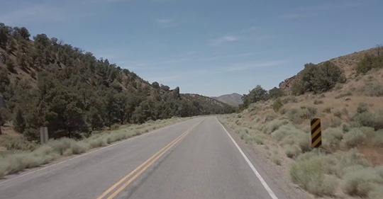
Mile 1866: Paved Alternative from Austin, NV to Middlegate, NV
Alternate route, Austin, NV
“Here is a longer video showing the paved alternative from Austin, NV to Middlegate, NV. After days of nothing but gravel, tough two-track, some hike-a-bike sections, and dusty roads, booking it along a great stretch of pavement is actually really nice. Especially when you have a total of 5 cars pass you for the entire 65 miles!”
“Below us, ‘Reese’s River’ Valley might have served for a sketch in the African desert: a plain of saleratus, here yellow with sand or hay, there black with fire, there brown where the skin of earth showed through her garb of rags, and beyond it were chocolate-colored hills, from whose heads curled blue smokes of volcanic appearance. Bisecting the barren plain ran a bright little stream, whose banks, however, had been stripped of their ‘salt grass:’ pure and clear it flows over a bed of gravel, sheds in a northerly direction, and sinks at a distance of about twenty miles.”
Richard Burton, The City of Saints, p. 486
Mile 1900: Smith Creek Station
“Before 8 A.M. we were under way, bound for Smith’s Creek. Our path stretched over the remainder of Reese’s River Valley, an expanse of white sage and large rabbit-bush which affords fuel even when green. After a long and peculiarly rough divide [Smith Creek Summit], we sighted the place of our destination. It lay beyond a broad plain or valley [Smith Creek Valley], like a huge white “splotch” in the centre, set in dirty brown vegetation, backed by bare and rugged hills, which are snow-topped only on the north; presently we reached the ‘splotch,’ which changed its aspect from that of a muddy pool to a yellow floor of earth so hard that the wheels scarcely made a dent, except where a later inundation had caused the mud to cake, flake, and curl—smooth as ice without being slippery. Beyond that point, guided by streams meandering through willow thickets, we entered a kanyon—all are now wearying of the name—and presently sighted the station deep in a hollow. It had a good stone corral and the usual haystack, which fires on the hilltops seemed to menace.”
Richard Burton, The City of Saints, p. 486-487
Mile 1900: Smith Creek Station
“One story about Smith’s Creek was reported in the August 1860 Virginia City Territorial Enterprise. ‘One day last week H. Trumbo, station keeper at Smith’s Creek, got into a difficulty with Montgomery Maze, one of the Pony Express Riders, during which Trumbo snapped a pistol at Maze several times. The next day the fracas was renewed when Maze shot Trumbo with a rifle, the ball entering a little above the hip and inflicting a dangerous wound. Maze has since arrived at this place (Carson City) bringing with him a certificate signed by various parties, exonerating him from blame in the affair and setting forth that Trumbo had provoked the attack.’
In another incident, two riders, William Carr and Bernard Chessy, got into an argument. Carr later shot and killed Chessy. Carr was arrested, found guilty, and had the dubious distinction of being the first man legally hanged in the Nevada Territory in Carson City.
William E. Hill, The Pony Express Trail: Yesterday and Today, p. 227
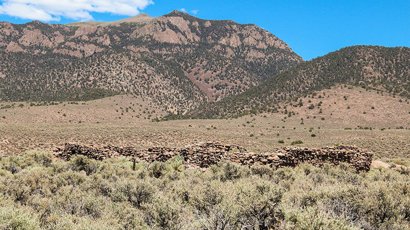
Mile 1915: Cold Springs Station
Cold Springs Station, NV
“[D]uring the Pyramid Lake War, three Pony Express riders were killed by Paiute warriors . . . One of them, Jose Zowgaltz, was Hispanic. He was ambushed as he crossed the thick aspen bottoms of Edwards Creek, north of Nevada’s Cold Springs Station (pictured). Suffering a mortal abdominal wound, Zowgaltz galloped to the station where, upon arrival, he slipped bleeding from his saddle and soon died.”
[N.B. Cold Spring Station is a few miles off the Pony Express Bikepacking Route, west of Austin, NV. There are three stations in this area, just north of the Route (starting from a turnoff at about Mile 1885), though there doesn’t appear to be any direct line between them. This is the part of the trail where Jan Bennett took a break from the miles of gravel for a nice paved stretch.]
“Party and train decamped at 1 P.M., and continue northwardly up valley. After proceeding 11 miles [from Smith Creek] come to rapid stream of pure water [Edwards Creek], 2 feet wide, deep, flowing from the Se-day-e Range [Desatoya mountains]. On this we encamp. Willows fringe it, and grass is to be found higher up in the cañon. I call the stream after one of my assistants, Mr. Edward Jagiello, a Polish gentleman; his surname being difficult of pronunciation, I have preferred his Christian name as the appellation.… Opposite our camp, in the range of mountains lying to the west of us, is a deep pass, in which can be plainly seen an extensive bottom of grass, and a creek running down from it into the valley in which we have been traveling. This creek, and the valley [Edwards Creek Valley] into which it flows, I propose calling after Major Frederick Dodge, the Indian agent of the Pi-Utes and Washos, who was so courteous to my party, and myself, at Genoa.”
[Edward Jagiello—meteorological assistant, chronometer keeper on the Simpson Expedition. Petersen, A Route for the Overland Stage, p. 11]
Petersen, A Route for the Overland Stage, p. 135
Mile 1944: Route Detour to Simpson Pass
Just past Sand Springs Station (at Mile 1944), the Pony Express Bikepacking Route stays on US 50 to Fallon, NV. The road at this point heads northwest. The original Pony Express Trail runs west at this point through Simpson Pass to Desert Station (or Hooten Wells Station) where it rejoins the Pony Express Bikepacking Route.
At Sand Springs Station (at Mile 1944) on the Pony Express Bikepacking Route at Ride With GPS, Jan makes a note: “Playa is unrideable.”
Jan’s comment (on Facebook):
“If one follows the route directly from Salt Lake City to Carson City, for around 500 miles, the only town directly on the route is Austin, NV where resupply consists of a minimally stocked convenience store with somewhat limited hours. Taking the difficulty of the section you rode into account, in addition to the vast distance from prior resupply, I felt that routing through Fallon was the best option. Thanks [Kurstin] for documenting your ride! I’m sure others will want to stick to the route as much as possible so this gives them that option.”
Kurstin Gerard Graham scouted the original trail through this section. Kurstin rode it from west to east (opposite to the track of the PX Bikepacking Route) and cut across some of the unrideable terrain just west of Highway 50.
To get to Simpson Pass while riding from east to west, Kurstin posted another map here, which follows dirt roads through the area. The turnoff is about 1/4 before the Sand Springs Station marker. [N.B. The second map does not cover the entire detour, just the western portion which offers a dirt road alternative harder-to-follow route on Kirstin’s original map. Also, FWIW, parts of this route seem hard to trace. Suggest anyone trying it be well stocked and very confident in their riding and navigation skills.]
I scouted the route between Sand Springs and Highway 95 in October 2020. My route reports are here:
“While some Pony Express stations were located in pre-existing buildings (on ranches, in stage stations, etc.), others had to be built from the ground up. What was it like to build a Pony Express Station in the 1860s?
For workers hired to build stations in Western Nevada, easy would not be a word to describe it! They built corduroy roads of willows in Carson Sink, fought hordes of mosquitoes, and erected station houses with adobe bricks. In preparing the bricks, they tramped the mud with their bare feet (to ensure proper consistency). This required at least a week of time and when they were through, the skin had peeled from the soles of their feet! One of these workers, J.G. Kelley, would eventually become assistant station keeper at one of the stations he built, Sand Springs.”
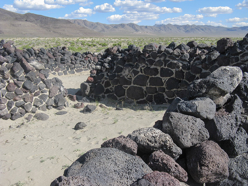
“Sand Springs Station [is] about 20 miles east of Fallon. This Pony Express Station was built in 1860, yet many of its walls still stand. After the station was abandoned, drifting sand from nearby dunes buried the structure, helping to preserve it. In 1977, archaeologists excavated and stabilized the station. Today, it’s managed by the Bureau of Land Management and open to the public.”
“Several sources identify Sand Springs as a station, including the 1861 mail contract. Like Cold Springs, this station existed due to the construction efforts of Bolivar Roberts, J. G. Kelly, and their crew in March of 1860 for the C.O.C. & P.P. Express Co. James McNaughton managed station operations for a time. On October 17, 1860, Richard Burton recorded his negative views of the roofless, dirty structure and its staff, stating that it was “roofless and chairless, filthy and squalid, with a smoky fire in one corner, and a table in the centre of an impure floor, the walls open to every wind, and the interior full of dust.” [41] Travelers found a reliable source of water at Sand Springs, but its poor quality often poisoned animals and probably made people ill.
In addition to the Pony Express, other individuals and businesses utilized Sand Springs until World War Two. The telegraph came through the area, and the site served as a freight, milling, and ranching center. Structural ruins from many of these activities still exist around the springs. In 1976, the site was determined eligible for the National Register. By 1981, the station was listed on the National Register of Historic Places and was structurally stabilized. This source locates the station’s ruins near Sand Mountain, about three-fourths of a mile north of Highway 50.
“About 11 A.M. we set off [from Sand Springs Station] to cross the ten miles of valley that stretched between us and the summit of the western divide still separating us from Carson Lake [i.e., Simpson Pass]. The land was a smooth saleratus plain, with curious masses of porous red and black basalt protruding from a ghastly white. The water-shed was apparently to the north, the benches were distinctly marked, and the bottom looked as if it were inundated every year. It was smooth except where broken up by tracks, but all off the road was dangerous ground: in one place the horses sank to their hocks, and were not extricated without difficulty.”
Richard Burton, The City of Saints, p. 491
Mile 1952: Sand Springs Station
“Sand-Springs Station deserved its name. Like the Brazas de San Diego and other mauvaises terres near the Rio Grande, the land is cumbered here and there with drifted ridges of the finest sand, sometimes 200 feet high, and shifting before every gale. Behind the house stood a mound shaped like the contents of an hour-glass, drifted up by the stormy S.E. gale in esplanade shape, and falling steep to northward or against the wind. The water near this vile hole was thick and stale with sulphury salts: it blistered even the hands. The station-house was no unfit object in such a scene, roofless and chairless, filthy and squalid, with a smoky fire in one corner, and a table in the centre of an impure floor, the walls open to every wind, and the interior full of dust. Hibernia herself never produced aught more characteristic.”
Richard Burton, The City of Saints, p. 491
Mile 2056: Mormon Station/Genoa, NV
“Mormons had established a permanent settlement at Mormon Station, now Genoa, which was a rankling thorn in [the local Native Americans’] flesh. It was, however, a genuine spine-stiffener for the feminine portion of the early-day cavalcades. There were white women there, the first since Salt Lake City, and real houses with vegetable gardens at the foot of the forested mountain.” . . .
Mormon Station was, to all intents and purposes, a trading post. It maintained a store and a boarding house that served appetizing meals with vegetables and bread. There was even a dinner bell at noon and at sunset. One of the buildings was, in later years, treated to a genteel two-store false front as deceptive as a cheap toupee and as useful, and was the oldest house in Nevada when, quite recently [in the 1940s] it was destroyed by fire.
In the late fifties, after the difficulties between the Mormons and the government were settled, harassed travelers found a United States Indian agent in Genoa. Widows and orphans from Indian massacres were placed in his charge to be returned to their homes when opportunity afforded.”
Irene D. Paden, The Wake of the Prairie Schooner, p. 437-438
Nevada Conditions
“The stretch between [Salt Lake City] and Carson City is some of the most unforgiving terrain there is. It is also some of the most beautiful, isolated, uninhabited, desolate, awe-inspiring land I’ve ever been in . . .
My biggest fear is that someone will get out there and not be adequately prepared and end up in a very bad situation.
I rode that stretch this summer [2019] but had to adjust my schedule to account for the heat of the day. I would stop riding around 1-1:30, aiming to be at higher elevation and around trees. I would find shade and would try my best to have just topped off water, or be near a water source. I would lay down and rest for a while, letting my body cool off while consuming water and electrolytes. I would eat once I had cooled off enough to stomach food. I would nap/rest until about 4-4:30 then would go for another 20 miles or so.
“One sometimes thinks of the desert as a great expanse of barren, shifting sand, but the Nevada desert is quite different. It is broken by almost a hundred separate mountain chains, all running north and south, and the arid stretches between are dotted with sagebrush and greasewood. It’s few rivers have no outlet to the sea, but spread into great marshes before being swallowed by the thirsty soil. Nearly 500 miles of the Pony Express route lay through this desolate and uninhabited [sic] wilderness.”
Ralph Moody, Riders of the Pony Express, p. 88
Nevada Route Deviations
There are two major route deviations in Nevada: one near Mile 1588 (to Ely) and one near Nile 1737 (to Eureka). These add nearly 100 miles to the original Pony Express Route, and are designed to give riders options for food and water. Following are general comments about this section from Jan Bennett (who mapped the rout) and Tim Tait. More specific details are in the Route Reports for the two mile markers listed above.
From Jan:
“Once you leave Salt Lake City there is no food resupply directly along the route until you hit Austin, NV, nearly 400 miles away.”
From Tim:
“[Y]ou’ll want to hit every store stop you can get your hands on out here. It’s slow rolling in an unforgiving environment. The elevation profile is deceiving. Pace will be much lower than expected. I was working on a unloaded rig, on single day legs, and was barely averaging 15mph. . . .
I think it would be safe to say be prepared for some significant swings from that 10 mph average, for large sections. There are sections out here that just scream, especially with a tail wind, and there are sections that will absolutely crawl due to sand or large gravel… or because of massive headwinds… and how those sections stack up end up changing ETAs and time between sections/services. Frustration on miles of washboards can make for a start/stop strategy that you might not have been prepared for. In terms of water, Utah is scorching hot in the summer time. Temps in Salt Lake are regularly in the 100’s in late July/early August. Most of the west desert isn’t high enough elevation to get you into much cooler temperatures than that. Winds will strip all the fluid out of you. Me personally, in the hottest parts of the summer, I would plan on 1.25-1.5 liters/hour of cycling, and I am on the lighter side of water consumption. For pespective, I ride the west desert in March-May, and then typically don’t go back until September/October.
“The first Pony Express rider going east after the attack upon Williams Station was “Pony Bob” Haslam, who set out for [from?] Friday’s Station on May 9. If he was not aware of the outbreak when he started, he quickly learned about it when he arrived in Carson City. Since the volunteers had taken all the horses to chase the Pah Utes, there was no change for him. Scores of men were frantically at work fortifying Penrod Hotel and everybody was armed. After feeding his own mount he rode on to Buckland’s, 75 miles away. When he arrived he found W. C. Marley, the station keeper, and Johnson Richardson, the rider who was to relieve him, in something of a panic.
Richardson refused to take the mochila on and Marley offered Haslam $50 to continue with it. This he agreed to do not because of the bonus, but because he felt it was his duty to do so. Changing horses he pounded on to Sand Springs where he changed again. Making still another change at Cold Spring he arrived safely at Smith’s Creek, having covered 190 miles without a rest.
Jay G. Kelley took the mochila and raced eastward with the news of the tragedy at William’s Station. He made his regular changes along the way, briefly told his story, and pushed on to Ruby Valley, his home station. From there both mochila and news were rushed eastward. Every rider along the route, knowing the necessity for both reaching Salt Lake City at the earliest possible moment, outdid himself in an effort to make the best possible time.
Eight hours after arriving at Smith’s Creek, Haslam turned back with the west bound mochila, possibly on May 12, the day of the battle at Pyramid Lake. At Cold Spring he found that the station had been burnt, the station keeper killed, and the horses driven off. After watering and feeding his own horse, he rode on. Upon reaching Sand Springs he found only the stock tender there whom he persuaded to accompany him for fear he would be killed if left alone.
At Carson Sink he found fifteen men, probably the most of them survivors of the battle at Pyramid Lake, barricaded in the station. Leaving them to hold the place he rode on to Buckland’s, arriving only three and a half hours late.
Marley was so overjoyed to see him back alive that he doubled the bonus promised him. After resting an hour and a half he sped on to Carson City, which he found a city of mourning for those slain at Pyramid Lake. He reported to Bolivar Roberts, then rode on to Friday’s Station. When he arrived he had covered 380 miles and had been in the saddle thirty-six hours.
Settle and Settle, Saddles and Spurs, p. 150-151
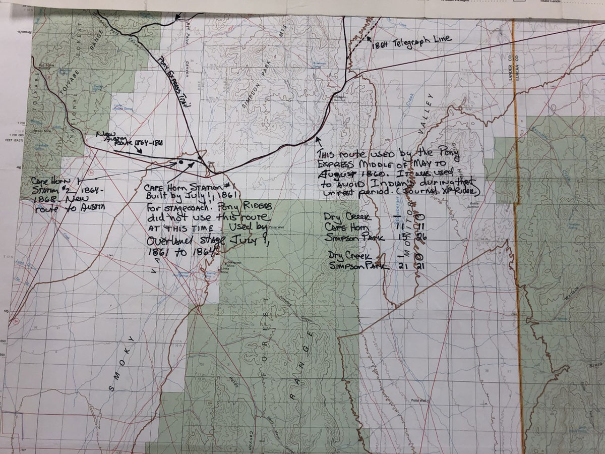
Pony Express Route Near Austin, NV
Routes near Austin, NV
“Thanks to research from Joe Nardone, and some sleuthing from Trails staff: ‘As you can see, there’s a lot going on [near Austin]. First, there’s a route that stays north of the Simpson Park Mountains – you can see only part of it on this map. That’s the main route that was used for the entire existence of the PX, except during the Paiute War. Then there’s the route that dips around the south end of the Simpson Park Mountains. His (Joe Nardone’s) note says it was used by the PX from mid-May-Aug 1860, so the riders could avoid the Indians during the Paiute War. He cites a Pony Express rider’s journal for that information. Now look at the bottom of the dip where he’s (Joe Nardone) marked Cape Horn Station. There’s a third route peeling off of that, where he shows the Cape Horn Station. That was a stage station and a stage route used July 9, 1861 to 1864 by the Overland Stage… According to Joe, the Pony riders never went that way.'”
“This last July I went back through Utah and Nevada to secure water for riders at the ranches along the route. The ranch owners are happy to let you access water on their properties, they just request that you let them know that you are there and on their property.
Also, in order to ride through the Pathfinder ranch properties in Wyoming, to the west of Casper, you will need to request permission and sign a waiver. They are happy to have riders pass through.”
“From West of Casper, WY to outside of Sacramento, CA free camping on public lands can happen almost anywhere you can find a place to put your sleeping bag down. I wouldn’t necessarily suggest a hammock as there aren’t very many tall things to tie off to out in the high desert.