Below are some general notes about the route in California. For a detailed accounting of my scouting rides from Echo Summit to Sacramento, see the Scouting California page.
Camping
“From West of Casper, WY to outside of Sacramento, CA free camping on public lands can happen almost anywhere you can find a place to put your sleeping bag down. I wouldn’t necessarily suggest a hammock as there aren’t very many tall things to tie off to out in the high desert.
“In June of [1859] Captain Simpson, of the United States Topographical Engineers, surveyed a new route from Camp Floyd to Genoa, which it was claimed would shorten the distance about 300 miles. The distance from Camp Floyd, by the old Humboldt route to Genoa, was reported to be 854 miles, by the Chorpening route through Ruby Valley about 709 miles, and by the Simpson survey 565 miles.
In September the company cut hay and made the necessary preparations to move down on to the Central or Simpson route, which they did the winter following.”
Thompson and West, History of Nevada (1881), pg. 105
Mile 2062-2098: Original Route over Echo Summit
“The Pony Express, in 1860, passed up West Carson Canyon into Hope Valley and then northward through Luther’s Pass, up to Echo Lake by way of Johnson’s pass, at the left of the highway summit, and down over Slippery Ford to Strawberry.”
[N.B. This route was the initial route over the Sierra Nevada. It only lasted five weeks. there is a Pony Express memorial at the site of Woodford’s Station (Junction of Highways 88 and 19): “The station functioned from April 3 to April 28 or 29, 1860. At such time, the route was redirected when Rollin Daggett offered free toll over Daggett Pass in Nevada. Thus, Pony Express riders were able to avoid three remount stations. A California Registered Historical Landmark’s marker identifies the station site, now covered by Highway 88. It reads: ‘During initial five weeks of its operation in 1860, an important remount station of the famous Pony Express was located a few feet from here at Cary’s Barn.'” The Pony Express Bikepacking Route follows the later route over Kingsbury Grade and through South Lake Tahoe.]
Irene D. Paden, The Wake of the Prairie Schooner, p. 449
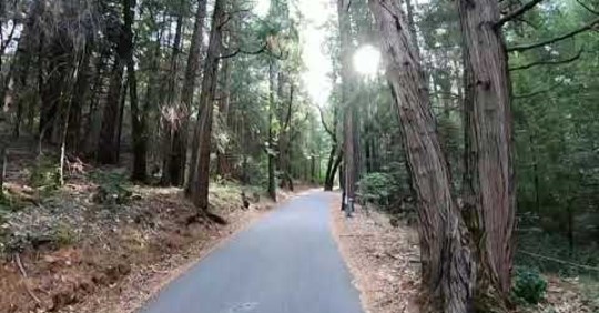
Mile 2076: South Lake Tahoe Bike Path
Bike path, South Lake Tahoe, CA
“Last section of the trip. The ride out of South Lake Tahoe to cross the last bit of the Sierra mountains is an ass kicker. If you’re wanting to get gnarly I would really suggest a hard tail mountain bike, flat bar, and true suspension fork. I really don’t know that there’s an ideal setup for the route. There’s plenty of great, graded, relatively smooth dirt roads. There’s a good amount of rough double track, rocky double track, and a nice sprinkling of technical single track. Some of the downhills along the way would be great on a full squish, unloaded mountain bike, but you can take it slow and be deliberate with your lines and get away with less bike.”
“[The hostelry at Strawberry] belonged to a man named Berry who sold straw under the name of hay and received the unflattering sobriquet old Straw Berry.”
Irene D. Paden, The Wake of the Prairie Schooner, p. 449
Mile 2126-2148: Pacific House to Placerville
Fifteen miles above Hangtown [Placerville] the teams reached Pacific House, at fourteen, Bullion Bend, where a stage was held up and loot is supposed to be buried; at twelve, Sportsman’s Hall (named from the multitude of card sharks that frequented its tables) where the relay waited for the Pony Express rider on his mad dash. It was the chosen stopping place for teamsters freighting to the Nevada mines and had stable room for several hundred horses. Then they came to Five Mile House and on down to Hangtown Creek with all its water drained out into ditches to feed the big toms.'”
Irene D. Paden, The Wake of the Prairie Schooner, p. 453
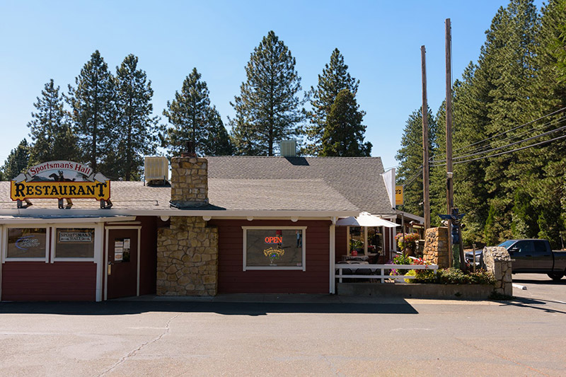
Mile 2135: Sportsman's Hall
Sportsman’s Hall, CA
“Sportsman’s Hall was California’s only Home Station. It was frequently called the Twelve Mile House and sometimes simply referred to as ‘The Hall.’ It was opened in 1852 by Scotland immigrants John and James Blair. Sportsmans Hall was one of the most popular and most important places on the trail. No other inn approached its size or the quality of its accommodations. . . Originally it was a hotel, restaurant, and a stage stop that could accommodate 500 horses, with extensive corrals. It has burned to the ground and been rebuilt twice. Part of the original structure still exists, and if you look carefully, you will see the beams, hand hewed, that hold the roof up.”
“A number of sources list Sportsman’s Hall as a station, which also appeared on a contract station. Herbert Ralph Cross identifies Sportsman’s Hall as a “rider relay” or home station, fifty-six miles from Sacramento and twelve miles east of Placerville. A California Registered Historical Landmark’s plaque at the site reads:
This was the site of Sportsman’s Hall, also known as the Twelve-Mile House. The hotel operated in the late 1850’s and 1860’s by John and James Blair. A stopping place for stages and teams of the Comstock, it became a relay station of the central overland Pony Express. Here, at 7:40 a.m., April 4, 1860, Pony rider William (Sam) Hamilton, riding in from Placerville, handed the Express mail to Warren Upson who, two minutes later, sped on his way eastward.
“And Hangtown—what of it? Built flimsily at a carefree slant on the two sides of a shallow pine-filled canyon, the log-framed, canvas-roofed buildings of ’49 gradually gave way to better arrangements. Men found there was sure money to be made in limber, and small mills hacked out heavy timbers for warmer houses. A crude but effective line of stores centered the rambling elongated town and soon became a recognized goal for gold seekers. It was the third largest city in the state. And, only second to Sacramento, Hangtown symbolized for the overland Argonaut, their arrival in the west. . . .
The settlement started its diversified career under the title Dry Diggings, but was rechristened in honor of its early citizens’ well meant exertions in the cause of justice. Two Frenchmen and a Chileno were hanged on an oak in the center of town in January, 1850.Several other executions followed rapidly—possibly too rapidly. The place was irrevocably dubber Hangtown. When California became a state, later in the same year, the more aesthetic citizenry had its name legally changed to Placerville.. In the spring of ’53, still struggling for less violence, they narrowly prevented another lynching and had the oak cut down. The top was made into souvenirs, but the stump is beneath a building within a few feet of the memorial plaque.”
Irene D. Paden, The Wake of the Prairie Schooner, p. 453-454
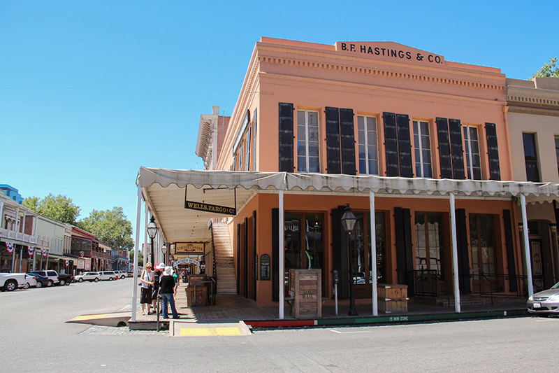
Mile 2207: Western Terminus
B. F. Hastings Bank Building, Old Town Sacramento, CA
“Great Place to visit the Pony Express Trail and discover its history- Old Town Sacramento! The Pony Express Terminal, also known as the B. F. Hastings Bank Building, was one of the end points of the Pony Express. This building was completed in 1853 and today is part of Old Sacramento State Historic Park.”
[N.B. There is a Pony Express memorial across the street from the bank. This is the western terminus of the Pony Express Bikepacking Trail.]
“. . . there were as many as two dozen inns or taverns maintained by Mormons in El Dorado County and surrounding areas. Porter Rockwell himself maintained three of them in 1849-50. The most famous of the inns was known as the Mormon Tavern, situated on the Placerville road, about twenty miles west of Hangtown (Placerville). It was the frequent meeting place of Howard Egan, Porter Rockwell (who went under the alias of Brown), Charles C. Rich, and Amasa M. Lyman. Captain Asahel A. Lathrop was the proprietor. A captain of ten in 1847, it was he who had been the spiritual leader of the relief train to the southern settlements in the winter of 1847-48, returning to Utah with cattle and supplies.”
“The year following the establishment of the Pony Express, the Southern Daily Overland Mail, which had been established in 1859 through northern Texas to California was transferred to the Central or Simpson route, its regular trips commencing on the first of July, 1861. . . .
From the date of the removal of the Southern Overland Mail to the Central route, and the establishment of the Daily Stage line, the mail facilities and means of transportation into and through the Territory began to improve rapidly. New roads were constructed and the old ones were improved, so that heavy loads of merchandise could be transported and faster time made over them. Two toll-roads were built across the Sierra; one called the Placerville, and the other the Dutch Flat, or Donner Lake route. These were wide enough so that teams could pass in the narrowest places. The overland stage ran with great regularity, and its business was conducted with promptness and dispatch.”
Thompson and West, History of Nevada (1881), pg. 105-106
“From West of Casper, WY to outside of Sacramento, CA free camping on public lands can happen almost anywhere you can find a place to put your sleeping bag down. I wouldn’t necessarily suggest a hammock as there aren’t very many tall things to tie off to out in the high desert.