“From the moment they had passed the junction of the rivers the emigrants were fired with only one thought: to get across the South Platte. The Colorado gold-seekers of ’59, Pikes Peakers as they were called, might remain comfortably on the south bank, but travelers to Oregon and California, and, later, to Montana and Idaho must ford this large watercourse which unaccommodatingly swung too far to the left for their purpose.
Many crossed immediately above the forks, following Frémont’s example. There were also several little-used fords, but the great bulk of the migration crossed four miles above Brule, Nebraska at a spot called the Lower California Crossing, although in the late fifties and the sixties the Upper California Crossing at Julesburg, Colorado, became a rival. . . .
Everything considered, the crossing near Brule was the greatest ford of the Overland trek . . . [T]here were hundreds of wagons each day during the season, which must get through the quicksand of the South Platte ford or give up the journey. it was one of the few dangers of which they had definite advance notice. They could, and did, worry about it from the time they left home . . .
From the days of the first fir trappers, on through the Oregon migration and the California gold rush, it was in everybody’s way.”
Irene D. Paden, The Wake of the Prairie Schooner, p. 106-109
Dogtown and Dobytown
“Beginning in 1858 there were two famous—or infamous—appendages of Fort Kearny, primitive communities which supplied vital needs for civilians and soldiers alike. Eight miles to the east, just off the reservation line, was Valley City, or Dogtown. Just beyond the western line, two miles away and therefore a much bigger and livelier place, was Kearney City, or Dobytown. . . .
Monthly mail between Independence, Missouri, and Salt Lake City, Utah, began in the summer of 1850. In 1858 mail service went on a weekly basis, and with this began the systematic transportation of passengers, first by mail wagon, later by the famous Concord coaches. To facilitate this service, the company built stage stations at intervals of town or twelve miles. This was the actual beginning of Valley City and Kearney City. The former was related to a ‘swing station’ where horses were changed; the latter evolved from a ‘home station’ where drivers were changed and meals offered the passengers. . . .
The Pony Express of 1860-1861, operated by Russell, Majors & Waddell, of freighting fame, shared most of its stations with the Holladay company along the main Platte; accordingly, there were Pony Express stations at Valley City and in the Fort Kearny vicinity. Contrary to widespread impression, the Pony Express riders did not gallop up to Moses Sydenham’s sod [sutler] post near the Fort Kearny parade ground; they kept right on going to the log station west of the fort, and mail by stage or Pony Express was carried back to the fort from there.”
Merrill J. Mattes, The Great Platte River Road, p. 216-217
Gilman Ranch
The Gilman brothers had left the family homestead in Bartlett, New Hampshire, in 1854 and drifted west, stopping first in Iowa and then moving on to Nebraska. In the early summer of 1859, at the height of the Pike’s Peak gold rush, they were hauling merchandise to sell to the miners in the Rocky Mountains: drugs, goods, clothing, whiskey, ammunition, iron pipes, wheelbarrows, tools, and one luxury item—”a fine red, iron pump … A sign of affluence on the frontier where a windlass and bucket were the usual means of getting water from the well.”
About eighty miles west of Fort Kearny, nearly to the Colorado border, the Gilman brothers had the good fortune to break a wagon axle. They were about seventeen miles east of Cottonwood Springs, a well-established stop for travelers along the Oregon Trail (it would become the site of Fort McPherson). Unable to go forward to Colorado or retreat back to Nebraska City, John and Jeremiah Gilman settled where the wagon gave out. Within days they were trading their goods with nearby Sioux and Cheyenne Indians for buffalo robes. Emigrants headed west in wagon trains soon stopped, too. The Gilman brothers decided to grow where fate had planted them. The first sign of their permanence was that they dug a well, lined it with cedar posts, and installed the red iron pump, a landmark for travelers into the West that would become beloved in Nebraska folklore.
Christopher Corbett, Orphans Preferred, p. 107
Jules Stretch
This stretch of the road, from Julesburg to “French Louie’s” [Pole Creek Station] was known as the “Jules Stretch.” The stretch of road going from the Pole Creek crossing and “French Louie’s” northward, to the next Pony Express Station, Mud Springs, and was known as the “Thirty Mile Stretch.”
Loren Avey, The Pole Creek Crossing, p. 24
Lodgepole Creek
“Our Camp at Pole Creek the night’ of November 4, 1864, was very bleak and dreary. Pole Creek was a vast trough in the plateau. It had a bed wide enough for the Mississippi River at St. Louis. Through this bed the arroyo of the stream ran, a bed of beautiful tawny sand about a hundred yards wide, and cut down from ten to fifteen feet. Sometimes the arroyo was wider, and sometimes narrower, but from Julesburg to the crossing, thirty-five miles, there was nothing, as before stated, in the shape of a tree or bush. It was absolutely devoid of any vegetation except the grass. And above the arroyo the ‘flood plain’ of the stream, if it could be so called, was as level as a floor for distances out of sight. Occasionally in the arroyo there were little clumps of drift roots and brush, sometimes a small, dead, drifted pine. Lodgepole Creek was said to have a well-defined bed for two hundred miles, and to head at the Cheyenne Pass, in the Rocky Mountains.”
Eugene Ware, Indian Wars of 1864, p. 364
Lower and Upper California Crossings
“Between Fort Kearny and Fort Laramie there were only two divergences that are noteworthy; both pertain to the late period of the trail. Until 1859 all travel on the south bank of the Platte crossed the south fork of the river west of its junction with the north fork. The trail then moved northwest up the ‘peninsula’ between the south and north forks of the river and through Ash Hollow before reaching the valley of the North Platte. It then continued up the south bank to Fort Laramie. The discovery of gold in Colorado let to the Pike’s Peak trail southwestward up the South Platte and another connecting trail northward to the North Platte via Courthouse Rock, for which Julesburg, Colorado, became the new junction point.”
[N.B. The first crossing became known as the Lower California Crossing, and the later crossing near Julesburg was the North California Crossing. The Pony Express used the North California Crossing. Julesburg was the most problematic station at the opening of the Pony Express.]
Merrill J. Mattes, The Great Platte River Road, p. 6
Mile 177: Rock Creek
“A weary drive over a rough and dusty road, through chill night air and clouds of musquetoes, which we were warned would accompany us to the Pacific slope of the Rocky Mountains, placed us about 10 P.M. at Rock, also called Turkey Creek surely a misnomer ; no turkey ever haunted so villainous a spot ! Several passengers began to suffer from fever and nausea; in such travel the second night is usually the crisis, after which a man can endure for an indefinite time.”
Richard Burton, The City of Saints, p. 30
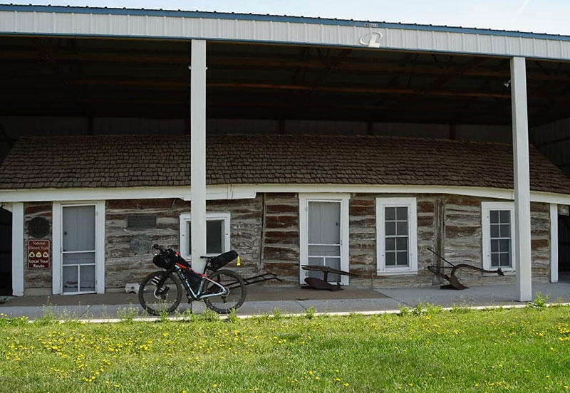
Mile 178: Rock Creek Station
“Rock Creek station was established along the Oregon-California Trail in 1858 to sell supplies and other services to the emigrants. The station subsequently served as a relay station for the Pony Express, and finally as a stage station for the Overland stage. To the northwest of the old station site is the finest stretch of pristine trail ruts in southeastern Nebraska. These ruts, which cover 1600 feet, are quite dramatic in appearance.”
The George Winslow Grave site is located nine miles northwest of Rock Creek Station and is one of the famous gravesites on the Oregon Trail. Although historians have estimated that 30,000 persons died on the trail between 1842 and 1860 (an average of 15 per mile), the actual number of marked and identified gravesites remaining today is quite limited. Thus each positively identified and marked gravesite which has survived is respectfully honored. The George Winslow grave is one of these. Winslow died on June 8, 1849, and his grave was marked by others of his company. Winslow’s sons returned to Nebraska in 1912 to erect a more permanent monument at the site, and the Winslow family still makes periodic pilgrimages to the grave.
George Winslow wrote a letter to his wife from Independence, MO., May 12, 1849. Mrs. George Winslow gave it to her grandson, Carlton Winslow, in whose name it was presented to the Nebraska State Historical Society, together with an excellent copy of a daguerreotype of George Winslow, taken in 1849. In the letter he writes:
“My dear Wife: We have no further anxiety about forage: millions of buffalo have existed for ages on these vast prairies, and their numbers have been diminished by reason of hunters, and it is absurd to think we will not have sufficient grass for our animals. We have bought forty mules, which cost us $50 apiece. I have been appointed teamster, and had the good luck to draw the best wagon. I never slept better in my life. I always find myself in the morning on my bed, rather-flat as a pancake. As the darn thing leaks just enough to land me on the terra firma by morning, it saves me the trouble of pressing out the wind; so who cares?
My money holds out very well. I have about $15 on hand out of the $25 which I had on leaving. We engaged some Mexicans to break the mules. To harness them they tied their fore-legs together and threw them down. The fellows then got on them and wrung their ears which is the tenderest part. By that time they were docile enough to take the harness. The animals in many respects resemble sheep; they are very timid, and when frightened will kick like thunder. They got six harnessed into a team, when one of the leaders, feeling a little mulish, jumped right straight over the other one’s back.
I do not worry about myself then why do you for me? I do not discover in your letter any anxiety on your account; then let us for the future look on the bright side and indulge in no more useless anxiety. It effects nothing, and is almost universally the bugbear of the imagination.
The reports of the gold region here are as encouraging as they were in Massachusetts. Just imagine to yourself seeing me return with from $10,000 to $1,000,000. I do not wonder that General Taylor was opposed to writing on the field, I am now writing on a low box, and have to ‘stoop to conquer’.
Your Loving Husband, George Winslow.”
On May 16 this company of intrepid men, rash with the courage of youth, set their hearts and faces toward the west and began their long overland journey to California, and by night had crossed “The Line” and were in Indian country. Though slowed by frequent rains and mud they made their way up the Kansas River. With mud sometimes hub deep, and broken wagon-poles as a hinderance they reached the lower ford of the Kansas, just below the Rock Island Bridge at Topeka on May 26th, having accomplished about 50 miles in 10 days. The wagons were driven onto flat boats and poled across by 5 Indians. The road then became dry, and they made rapid progress until the 29th, when George Winslow was suddenly taken violently ill with cholera. Two others of the party also suffered symptoms of the disease. The company remained in camp three days and with the sick seemingly recovered, it was decided to push on. Winslow’s brothers-in-law, David Staples and Bracket Lord, or his uncle, Jesse Winslow, were in attendance of George Winslow, giving him every care possible. His condition improved as they travelled and on June 6th they reached the place where the trail crosses the Nebraska-Kansas state line, Mr, Gould wrote:** “The road over the high rolling prairie was hard and smooth as a plank floor. The prospect was beautiful. About a half-hour before sunset a terrific thunder shower arose, which baffles description, the lightning-flashes dazzling the eyes, and the thunder deafening the ears, and the rain falling in torrents. It was altogether the grandest scene I have ever witnessed. When the rain ceased to fall the sun had set and darkness closed in.” (Their location was just east of Steele City, Jefferson County.)
To this storm is attributed George Winslow’s death. The next morning he appeared as well as could be expected, but by 3 o’clock his condition worsened, and the company encamped on Whiskey Run. He failed rapidly, and at 9 a.m. the 8th of June, 1849 he died. For George Winslow the trail ended here.
The Oregon Trail, Rock Creek Station, Nebraska to Fort Laramie, Wyoming, p. 1-2
Mile 197: Big Sandy Station
“A little after midnight we resumed our way, and in the state which Mohammed described when he made his famous night journey to heaven—bayni ‘Z naumi wa ‘I yakzan—we crossed the deep shingles, the shallow streams, and the heavy vegetation of the Little Sandy, and five miles beyond it we forded the Big Sandy. About early dawn we found ourselves at another station, better than the last only as the hour was more propitious. The colony of Patlanders rose from their beds without a dream of ablution, and clearing the while their lungs of Cork brogue, prepared a neat dejeuner a la fourchette by hacking “fids” off half a sheep suspended from the ceiling, and frying them in melted tallow. Had the action occurred in Central Africa, among the Es quimaux, or the Araucanians, it would not have excited my attention: mere barbarism rarely disgusts; it is the unnatural cohabitation of civilization with savagery that makes the traveler’s gorge rise.
Issuing from Big Sandy Station at 6 30 A.M., and resuming our route over the divide that still separated the valleys of the Big Blue and the Little Blue, we presently fell into the line of the latter, and were called upon by the conductor to admire it. It is pretty, but its beauties require the cosmetic which is said to act unfailingly in the case of fairer things the viewer should have lately spent three months at sea, out of sight of rivers and women.”
Richard Burton, The City of Saints, p. 30-31
Mile 235: Oak Grove Ranch Marker
Just after Mile 235, near the town of Oak, is a historical marker commemorating the August 7, 1864 raid on this ranch.
Irene D. Paden, The Wake of the Prairie Schooner, p. 76 (discussing "The Narrows")
Mile 238: Map of The Narrows
A map of The Narrows, from Root and Connelley, Overland Stage, p. 864.
Root and Connelley, The Overland Stage to California, p. 864
Mile 238: The Narrows
“The regular correspondent of the St. Louis Missouri Democrat went over the line in June, 1861, and wrote from Denver to his paper (issue of July 9): ‘Taking into consideration the distance and the nature of the country through which this Company has located its route, it is without doubt the most convenient and best equipped of any on the continent. The road itself cannot be surpassed; there is but one bad piece in it from St. Joseph to Denver. I allude to what is called the “Narrows,” which are on the [Little] Blue, about two hundred miles from St. Joseph, and are caused by the near approach of the river to the bluffs. . . . This is no doubt a dangerous pass for an inexperienced driver; but none such are employed by the company. . . .
‘In passing the Narrows, our party experienced no little uneasiness . . . and by dark we had fully made up our minds to receive a bath. . . . The moon went down . . . the night became so black that it was impossible to see a foot from the coach, the wind came bowling wildly over the prairie, and the incessant noshes of lightning, together with the sharp peals of thunder, breaking seemingly just overhead. . . . Charley (the driver] lighted the coach lamps, meantime answering indefinitely questions put in agitated tones. We gathered, however that we must get through the Narrows before the rain reached us. . . .
“‘Presently we knew the coach to be entering a gulch, close to one side the lightning revealed the waters of the Blue, on the other the rough sides of the bluff, and as we slowly passed a crevice the bright eyes of a coyote, crouched a few yards from the window, flashed in menacingly upon us. . . . Suddenly there was cry from the box to ‘!ean to the right.’ No set of frightened school boys ever obeyed more quickly the commands of a severe pedagogue. . . . As we moved the coach took on abrupt turn, the lash was vigorously applied to the mules, and the next moment the cheering cry of “all right” relieved us of all further enxiety. In making this turn the near wheels come within a foot of the bank, the road inclines toward the river, so that if the ground happens to be wet there is no way to prevent the conch sliding off into the water, or too short a tum upsetting the institution and its contents . ‘ (A map of the Narrows is given in Root and Connelley, Overland Stage, p. 364.)”
george Root, "Pike's Peak Express Companies," Part IV, Kansas Historical Quarterly, Vol. 14, No. 1 (1944) p. 72, n. 447
Mile 238: The Narrows
“Forty-two miles west of the George Winslow grave the emigrants approached a troublesome portion of the trail known as “The Narrows”. Just northwest of the town of Oak (Nuckolls County-approximately 1 3/4 miles). Here the Oregon Trail was squeezed between the Little Blue River and a stretch of high, rugged bluffs which were impassable for wagons. The trail became so tight through portions of this area that there was room for only one wagon at a time to pass through this narrow strip between the bluffs and the river. Until the Indian Wars of 1864 the area was only a minor Oregon Trail landmark but in 1864 the NARROWS suddenly assumed a much more sinister meaning, for the geography presented the Indians with an ideal spot to ambush an emigrant train, a freight train or a stagecoach.
“In August of 1864 the telegraph line into Fort Kearny crackled with messages of depredations up and down the Platte Valley. But here, there was no telegraph communication and that August, Sioux, Cheyenne and Arapahoe Indians of Nebraska seized the opportunity presented by the withdrawal of Federal troops from the west during the Civil War to make a concerted effort to drive the encroaching white settlers from their land. During August, 1864, nearly every settlement and way station between the Big Sandy and Julesburg (400 miles) was attacked. Settlements and isolated farms were abandoned or destroyed, and travel ceased on the Oregon Trail for several months. A local family name Eubanks was attacked in the vicinity of the Narrows.”
“(Note: A present day visitor will find viewing the site quite difficult due to a combination of restrictive terrain and lack of access. Alterations in the course of the river and the subsequent erosion along the bank have cut into the Narrows and obliterated the Oregon Trail. Dense vegetation now lines the river bank and bluffs, and unlike the Oregon Trail days, there are now few vantage points from which a visitor may view the Narrows. The best place from which to see the Narrows is located at a point along the Oregon Trail, just off the graveled county road one-half mile west of the little town of Oak.)”
The Oregon Trail, Rock Creek Station, Nebraska to Fort Laramie, Wyoming, p. 4-5
Mile 238: The Narrows
“According to our maps, “the Narrows” was the next place of interest. It is mainly notable because, at this point on the Little Blue, the emigrants seemed to forget all their hard-learned rules of Indian strategy and crowded their wagons into a bottleneck between the river and encroaching bluffs.”
Irene D. Paden, The Wake of the Prairie Schooner,p. 76
Mile 258: Liberty Farm Station
“The storm had been local and, after we had worked our way slowly through ten more miles of mud, things became more normal. Along little roadways with reassuringly solid bases we really enjoyed the refreshing, pungent odor of earth freshly drenched and strung with puddles. The sun reflected pleasantly from the white knoll at the site of the old Liberty Farm Station and struck diamond points of light from the rain-soaked masses of trees behind it. The station did not survive the terrible massacre in 1864 but was replaced by one known as Pawnee Station located at a more favorable site.”
[N.B. the Pony Express Bikepacking Route shows this landmark about a quarter mile off the Route on Road 18C as it heads south to Deweese. Other sources show it on the main road (which the Route follows) between Mile 258 and 259]
Irene D. Paden, The Wake of the Prairie Schooner, p. 77
Mile 275: "Snow's Corner" Oregon Trail Stone Marker
Sometimes this stretch is referred to as “Nine Mile Ridge.” The stone marker was erected by the State of Nebraska in 1912. Located at https://goo.gl/maps/EHArEhZmXwpZRR4EA.
A freight train consisting of eight wagons loaded with hardware for Denver, was attacked Sunday morning, August 7, 1864, by a party of Cheyenne and Arapahoe Indians. Five men were killed instantly, a sixth was mortally wounded, and the wagons were burned. (Brown, 2007) The bodies and smoking wagons were found by two young couples out for a Sunday morning ride from Thirty-Two Mile Creek station and on Monday morning Overland Stage Line employees from the station arrived. The wounded teamster was able to give a few details of the attack before he died. The men were buried beside the trails 140 yards south of the OCTA marker. This is the only known burial site of white men who met death in Adams County due to hostile Indian activity. The Nova-Color OCTA marker was installed in 1996 on the south side of the road at the edge of a broad and deep ditch. Franzwa’s Maps of the Oregon Trail shows ruts southeast of the markers, but with the installation of a center pivot irrigation system several years ago, they are no longer visible. The next image shows the flat marker indicating the burial site.
The trail angled northwest across this steep drainage and must have been a hard pull after rains. This quarter section has been cultivated for decades and swales are not visible. D. W. Kingley, Jr. and Will Locke flew the trail in June in 1985 looking for faded color in the crops due to soil compaction from the trail traffic, but no crop color contrasts were observed. In steeper areas that had been left in native pasture swales were clearly evident. This marker was erected by the Niobrara Chapter of the DAR in 1912.
At the stage station marker look west across the small valley of Thirty-Two Mile Creek to the pasture and you will see several parallel swales climbing west out of the valley. Low angle light of early morning or late afternoon places these swales in shadow and they are easier to see. Light snows will make the swales stand out and during a thaw following deeper snows, snow will linger in the swales and one can see them clearly enough to count. Binoculars would be helpful as the “swales” are a half mile distant. This area must have been one of the tougher pulls of the Little Blue/Platte Valley trail segment. The first problem was the steep descent down into the valley. The brake mechanisms on the wagons were not very effective and the weight of the wagons would have pushed hard on the oxen. They could have run a pole through the rear wheels to provide additional braking action. Crossing the creek would have required the first wagon travelers of the season to dig ramps on both banks and perhaps to double team. Re-digging the ramps would be required after periods of high water. Once the pull out of the little valley was accomplished, the going was smooth until the crossing of the West Branch of Thirty-Two Mile Creek. Elm Creek Station was built by the Holladay Stage Line as a replacement for the Lone Tree Station which was burned during the Indian Raid of 1864. The marker was erected by ACHS in 1973. The granite stone came from the foundation of the old Hastings Post Office.
“In time or course climbed slightly to a flat upland covered with grain. This was evidently Nine Mile Ridge, where in staging days stood Lone Tree Station. The solitary tree for which the station was named used to be visible for a long distance in each direction and helped to break the monotony of the bare, rolling prairie hills. It was hard to imagine such a condition faced, as we were, with ranches and roadsides planted thick with shrubs and shade trees.”
Irene D. Paden, The Wake of the Prairie Schooner,p. 77-78
Mile 290: Thirty-Two Mile Creek Stage and Pony Express Station
This location is almost exactly in the center of Adams County and the Thirty-Two Mile Creek Station name indicates the distance to Ft. Kearny. Russell, Majors, and Waddell formed the Leavenworth and Pikes Peak Express company in 1859 and most likely constructed the Thirty-Two Mile Station that year. Samuel Word kept a diary of his 1863 trip across the plains and the following words are from May 28: “We are now 32 miles from Fort Kearny. Am most anxious to reach Kearny for I expect to hear from home. Have just returned from a ranch close by, where immigrants and settlers to the number of 100 are congregated engaged in a genuine old-fashioned back woods dance. . . . The ranche was about 12 by 14 feet square covered with sod. . . . The house had what it would hold, the rest stood outside. . .many of the men were drunk from rifle whisky sold them by the proprietor of the ranche. His grocery was in one corner of the room. I left them dancing.” (Word in Renschler, 1997)
Ted Stutheit (1987) of Nebraska Game and Parks offers the following description: “. . . consisted of one long, low sod building. In 1860 became a Pony Express Station (Nebraska Pony Express Station No. 10). In 1861 it was a ‘Home’ station for the Overland Stage where hot meals were served to travelers.”
===========
“Thirty-Two Mile Station” is the site of another of the series of way-stations established during 1858 and 1859 along the Oregon Trail to serve the growing numbers of stagecoaches and freighter wagons which were joining the emigrant trains along the great roadway west. Named for its distance from Fort Kearny, Thirty-Two Mile Station never consisted of more than one long, low log-building In 1860 it became a Pony Express Station (Nebraska Pony Express Station No. 10). In 1861 it was a “Home” station for the Overland Stage, where hot meals were served to travelers. The station operated by George A. Comstock was abandoned in August of 1864, its proprietors and visitors fleeing to Fort Kearny for safety, and the Indians subsequently burned the station to the ground. 32 Mile Station, site of Pony Express Station (Nebraska No. 10 — Sec. 6, T.6N, R.10W — Adams County) is now in the middle of a plowed field, just off a county road A small marker at the side of the field commemorates the site. This site is on the National Register of Historic Places as an archeological site.
—The Oregon Trail, Rock Creek Station, Nebraska to Fort Laramie, Wyoming, p. 5
=========
The location is marked on the XP Bikepacking Route map just before Mile 290.
This section of the trail falls between branches of Thirty-Two Mile Creek and is very smooth. The inscription on the granite stone reads, “Oregon Trail Marked by the State of Nebraska 1912.” Scout troop 192 helped erect this marker.
Located at https://goo.gl/maps/uLX6HFid7PJHAMkV6. Note: The XP Bikepacking Route goes north of this marker. I you want to see it, sty on Oak Ridge to Junaita, then turn right. It rejoins the XP Trail about one mile up, just past the marker.
Mile 294: US 6 Oregon Trail Historical Marker and Pony Express Marker
The trail moves from southeast to northwest on gentle ground between two branches of Thirty-Two Mile Creek. Soon the travelers will descend to Muddy Station on the West Branch of Thirty-Two Mile Creek. The inscription on the historical marker reads:
The most traveled of the overland routes passed this point on its way to the great Platte valley highway to the west. The Oregon Trail started from Independence, followed the Kansas River west, and then the Little Blue north into Nebraska. It crossed the divide to reach the Platte near Fort Kearny.
In the 1830s trappers and missionaries recognized the Platte valley as a natural roadway. The first wagon train followed the 2,000 mile trail to Oregon in 1842.
An estimated quarter of a million travelers used this route in the twenty-five years after those first wagons. Moving slowly, only 10 to 20 miles a day, for the three-month trip, thousands of hooves, shoes and wheels pounded a wide trail into the prairie.
Oregon was an early goal. The ’49ers went through to California. Settlers, stage coaches, freight wagons, Pony Express riders and
military expeditions all used this prairie highway.
With completion of the Union Pacific Railroad this route fell into disuse, but the Oregon Trail has earned a permanent place in our history.
This marker was erected in May, 1963, by Nebraska Historical Markers Council and the Nebraska Roads Department. The National Pony Express Centennial marker, a granite stone with bronze plaques, was dedicated in May, 1966, by the Adams County Historical Society. In mid February of 2006, thieves pried off one of the bronze plaques and a few days later, with the investigation underway, the second plaque disappeared. Plans are underway by ACHS to replace the missing markers.
Located at https://goo.gl/maps/h6gvQ2audvbFWEg56. Note: This is just of the XP Bikepacking Route. If you want to visit this memorial, turn left onto US 6 (County Rod 73) just past Mile 294. the marker is just west of Roseland Ave. Turn north on South Prosser Ave. to rejoin the XP Trail (about one mile up).
This area was possibly the driest and windiest section of the pull from the Little Blue to the Platte Valley. Summit Station may have been established in 1860 for use as a Pony Express Station. Joe Nardone (2008) refers to it as an “added station”. The station was abandoned after the Indian raids and never rebuilt. Frank Root in The Overland Stage to California (in Renschler, 1997)wrote:
The distance between thirty-two Mile Creek and the Platte is twenty-five miles. Summit the first station, was twelve miles. It was one of the most lonesome places in Nebraska, located on the divide between the Little Blue and the Platte . . .From its vicinity the waters flow south into the Little Blue and northeast into the west branch of the Big Blue. The surroundings for some distance on either side of the station represented a region of sand-hills with numerous deep ravines or gullies cut by heavy rains or waterspouts and dressed smoothly by the strong winds that have been blowing through them almost ceaselessly for untold centuries. Very little in the way of vegetation was noticeable at Summit or in the vicinity. It was a rather dismal looking spot. . . Necessity compelled the stage men to choose this location however, for the distance from Thirty-two Mile Creek to the Platte, twenty-five miles, was over a somewhat rough and hilly road, and it was too much of a pull for one team.
Because of land leveling for irrigation, the area today appears to be fairly smooth although the pull out of the little valley of the West Branch of Thirty-two Mile Creek would have been hard work.
Summit Station was first marked in 1935 by Hastings Boy Scouts under the direction of A. M. Brooking, Hastings Museum curator. The original marker was cement with a circular bronze plaque. In the 1973 the Adams County Historical Society erected a new marker at the site made from granite from the old Hastings Post Office foundation.
=========
“Sand Hill” was located one and a half miles south of Kenesaw within the (SE corner of NEVi, Sec. 10, T.7N, R.12W), on the crest of the divide between the Little Blue and Platte River drainages. The name refers to the difficult sandy wagon road which called for double-teaming. This station also appears as “Summit Station” (Root and Connelley), “Water-Hole” in (Allen), and “Fairfield” in (Chapman’s interview with William Campbell), In 1863 it was described by Root as “one of the most lonesome places in Nebraska”. This station was another casualty of the Indian Wars of 1864.
—The Oregon Trail, Rock Creek Station, Nebraska to Fort Laramie, Wyoming, p. 5
Mile 304: Oregon Trail Marker One Mile South of Kenesaw Cemetery
Just west of Kenesaw the trail jogged sharply west and then north to avoid a lagoon that is hardly visible today. John Klusman, while taking a break from planting in May, 2008, explained that the land had been leveled and drained in such a way that the lagoon that had previously been so prominent was no longer visible. The writer jogged this section of the trail in the late 1970s and recalls a large lagoon that obviously would have caused the wagons to detour. The goal was to get to Ft. Kearny with as little wear and tear on stock and equipment as possible; they were not going to get bogged down in a lagoon to save a mile. This marker was erected by the State of Nebraska in 1914.
The location is at https://goo.gl/maps/NDVHDwQT6f9278jh6. Note: The XP Bikepacking Trail passes .2 miles north of this marker. To see it, turn left (south) on Smith Lane (Hwy 1A) for .2 miles.
The following lines rely extensively on the article by Randy Brown in the Spring, 2007, issue of Overland Journal, titled The Grave of Susan C. Haile. When I first visited this area in the late 1960s with Boy Scouts, it was generally known as the “Lone Grave.” Randy Brown writes, “Most assuredly, however, when Susan Haile died in 1852 hers was not a lone grave. This was in the midst of the ‘cholera corridor’, . . . .” Most likely there were dozens even hundreds of graves along the Thirty-two Mile Creek/Platte River Valley stretch, but we know only the Susan Haile grave location. We know of the Haile grave because of the existence of a headstone. Intriguing legends and questions accompany the Haile story. Who was she? How did she die? How was a gravestone transported to the spot?
Often extended family units or clans moved from Virginia and Pennsylvania to Tennessee and Kentucky and then again to Missouri. The Seawells, Susan’s grandparents followed this pattern and eventually settled in Missouri. Susan and R. C. Haile were married in 1836 when she was almost 19. Randy Brown searched for accounts of the journey but concludes, “Unfortunately, there is no contemporary account of the journey. They probably left the Missouri River in the Kansas City area, or they could well have headed northwest . . . to St. Joseph, one of the major outfitting towns of the time. . . . All that is known of the journey is that when they reached the Platte River in south-central Nebraska, Susan C. Haile died.” The legend of the “Lone Grave” began when settlers in the late 1860s discovered the engraved stone marker.
The legends explaining her death are interesting and can be found in many sources. According to the legend, they secured water from the government well approximately six miles southeast of the grave (see images 23, 24, 25). It has been suggested that this water had been poisoned by Indians and thus caused the death of Susan Haile. Scholars take issue with this explanation for several reasons: 1) the Pawnees who traveled in the area were not warlike or hostile, 2) the Pawnees would have used the water themselves, and 3) the Pawnees did not have a poison effective in a well. 1852 was the height of the cholera epidemic on the trail. It is more likely that Susan Haile drank contaminated water that infected her with cholera, a violent intestinal disorder that led to rapid dehydration and then death sometimes in less than a day.
The next part of the legend suggests that the grieving husband returned to St. Joseph and purchased a granite marker which he brought back to the gravesite in a wheel-barrow. Catherine Renschler and Randy Brown have read many sources and conclude that it is most unlikely that R. C. Haile pushed a stone 250 miles across the prairie in a wheel-barrow. But Brown asserts, “Part of the legend may be true. Richard Haile marked his wife’s grave with a headboard and could have returned to the settlements to get a proper marble headstone.. . .The wheelbarrow aspect, however, is undoubtedly an embellishment added in later years by local people.”
Bill Sole (1972) wrote about the “Lone Grave” for the Adams County Centennial Year Publication in 1972. The first marker was, he writes, “. . .chipped to pieces by travelers and relic hunters.” In 1900 children of Waterhouse Sunday School raised funds for a new marker and this one fell victim to souvenir hunters as well. The present stone was dedicated July 30, 1933, by members of the Hastings Outdoor Club.
Following communication with the descendants of Susan Haile and extensive research by Randy Brown and the Oregon California Trails Association, a new OCTA Plaque was installed and the Adams County Historical Society organized a program in Kenesaw followed by a dedication of the OCTA plaque at the grave site.
=======
In addition to the gravesite, this site is important for other reasons. Susan Hail is buried at the precise spot where the Oregon Trail broke over a small rise and came in view of the Platte River. The Nebraska City-Fort Kearny road passed north of this site about a mile and a half, joining the main Oregon Trail a little more than six miles west, There were several alternate roads in this vicinity. This was one of the great moments in the experience of the emigrants, for the first leg of the journey was now almost complete. Arrival at the Platte River meant that they were within striking distance of Fort Kearny, the first sign of civilization in this remote country. The Platte River was broad and flat, with little or no timber, quite unlike its appearance today. Perhaps because the broad flat treeless valley during spring flood once resembled a sandy seashore, early travelers called this spot “The Coast of Nebraska”. (Also it is noted some writers of the day wrote about the white canvas topped wagons moving through the deep prairie grass resembling “Ships at Sea” as they moved across miles of waving grasses).
Both northwest and southeast of the Susan Hail grave (Sections 18 and 19) are fairly extensive grassed over Oregon Trail traces, made by the passage of thousands of animals and wagons as they descended the low sandy hill towards the river.
Note: It has been recommended as early as 1975 by Historian Merrill Mattes and as recently as a March 1981 comprehensive report on historic sites and trail segment status by the National Park Service, United States Department of Interior, that the Nebraska Game and Parks Commission should seek adequate funding to purchase approximately thirty acres of pasture land. This site which would be an unmanned park administered from Fort Kearny State Historical Park, fifteen miles to the west would be called “Coast of Nebraska” as proposed by Merrill Mattes and the National Park Service.
—The Oregon Trail, Rock Creek Station, Nebraska to Fort Laramie, Wyoming, p. 6
========
The site is marked on the XP Bikepacking Route map.
The Nebraska Historical Marker explaining the Susan Haile story was erected by the Kenesaw Centennial Committee and the Nebraska State Historical Society. The smaller marker is inscribed, “In Search of Pony Express Station Marker. Sand Hill.” It was dedicated June 8, 2002, by James Stretesky, Adams County Bank, Dorlene and Vern Hunt, Family of Leonard Osler, Pony Express Trails Association, and Joe Nardone, Historian.
The XP Bikepacking Route notes a marker for the Sand Hill Station at the intersection of West 70th Street and 44 Road (Denman Ave) (approximately Mile 312.5). Google Street view puts the marker just north of the XP Route on 44 Road at https://goo.gl/maps/s1h7axVuwxib3HeR6.
Mile 312: Sand Hill/Gravesite Markers
Mile 312: Summit Station
“The trail lay to our left, easily accessible at all times; and on it, near the summit of the ride, the old stages found the last stop before the long waterless drive over to the Platte River. Here stood Summit Station. Perhaps ‘stood’ is not the best word, for the building was only three feet above ground and extended four feet below.”
[N.B. The Pony Express marker is just north of the Pony Express Bikepacking Route, on 44 Road (just before Mile 312). Also at this spot is the Susan O’Hale Grave Historical Marker.]
Mile 312: Summit Station
Mile 315: Buffalo Wallow Water Holes
“Seven miles beyond [Summit station – Mile 311] were the famous (or rather infamous) buffalo-wallow water holes. Theodore Talbot, who was with Frémont in 1843, minced no words in his description of them. ‘These ponds or wallows,’ he wrote, ‘are formed by the buffalo wallowing, an amusement they are very fond of. When any rain falls it is collected in these places and here the buffalo come to drink and stand during the heat of the day, ading their own excrements to the already putrescent waters. This compound warmed for weeks in a blazing sun and alive with animalcules makes a drink palatable to one suffering from intense thirst. Oh! that some over dainty connoisseur might taste of it!’ Emigrants of later years, warned by the numerous guidebooks that flooded the market, carried water for emergencies from the last creek. But very early Oregon-bound travelers, delayed by one accident and another on this, the longest waterless stretch they had to cross, were sometimes forced by the intensity of their need to use this nauseating substitute for water.”
Irene D. Paden, The Wake of the Prairie Schooner, p. 80
Mile 318: The Platte River
“And now the emigrants (and we after them) looked forward only a few miles to the first view of the great Platte River. Some say it was first known as the Nebrathka, an Otoe word for weeping water, because of the sad tones of its current rushing swiftly among the sandy islands. Later it was called the Platte by the French trappers on account of its gray flatness.”
Irene D. Paden, The Wake of the Prairie Schooner, p. 80
Mile 321: Dogtown
“In the trail days there was a utilitarian, if ugly, settlement at this junction [of the Nebraska City Road with the Oregon Trail] bearing the vulgar title ‘Dogtown.’ As late as 1865, it was the first town west of Marysville, Kansas, a journey of nearly a hundred fifty miles. It is likely that the name originated in the ‘town’ of ‘village’ of prairie dogs nearby. There were several prairie-dog settlements settlements along the Platte, each of some acres in extent, looking, so the emigrants fancied, like an immense field of sweet potato hills. The dumpy little creatures barked hysterically at the first wagons of each season, but grew more philosophical as the steady processions flowed by them.”
[NB. There appears (on Google Street View) a very small historical marker. It is off the Pony Express Bikepacking Route, a few hundred feet down Lowell Road. to reach it, continue south on Lowell Road past the turn off to Skeeter Creek Road, just before Mile 321]
Irene D. Paden, The Wake of the Prairie Schooner, p. 82-83
Mile 330: Fort Kearney
“Of the five historic trail ‘forts’—Kearney, Laramie, Hall, Boise, and Bridger—we were now approaching the first in point of geography, last in point of time. It was established in 1848 as a curb to the exuberant habits of the Indians and was the only one of the five actually to be built for the accommodation of soldiers (the other four were originally trading posts and were established much earlier). . . .In accordance with the casual habit of the day, the name was a duplication of an older and already abandoned fort on the Missouri River just below Table Creek.”
Irene D. Paden, The Wake of the Prairie Schooner, p. 83-84
Mile 333: Dobeytown
“Two miles to the west [of Fort Kearney] we arrived at the spot where once flourished the hamlet called Dobeytown, a squalid settlement of ‘dobe huts whose very mention was next door to an indelicacy. It was the ordinary type of hell-hole that clung to the fringes of any military reservation and, owing to the fact that Fort Kearney was far toward the western edge of its reserve, the group of mud buildings was within a mile or two of barracks.
We found Leo Nickels’ Ranch on the spot where many a foolish traveler lost his last cent–if not his life. The causal tourist may recognize it by a row of evergreens along the fence line instead of the more common cottonwoods whose silky fluff everywhere fills the air.
In staging days a large reserve stable for work stock was erected at Dobeytown, and the name Kearney City was arbitrarily selected in a vain attempt to throw a veil of respectability over the community. The name never ‘took’ with those who knew the place . . .
The permanent population was about two dozen inhabitants, mainly gamblers, saloonkeepers, and loafers who made a good living by running off emigrants’ stock at night, laying it to the Pawnee, and hiring out to find it the next day. Only the most cast-iron type of hard liquor was available at Dobeytown (as beer and wines were considered an unpardonable waste of hauling space), and the thirsty drivers and crews of the bull-drawn freight wagons were frequently drugged and robbed.
‘There was no law in Dobeytown, or at least none that could be enforced.’ The place was a grisly combination of delerium tremens, stale humanity, and dirt.”
Irene D. Paden, The Wake of the Prairie Schooner, p. 88
Mile 366: Plum Creek Station
“As the emigrants approached Plum Creek, which was considered as the very center of buffalo country, the wagons lurched squarely across dozens of deep and parallel paths—some scarcely a foot wide but close together, like plowed furrows—which the great beasts had made single-filing over the grassy dunes to the river. The busy wind has left no trace of these characteristic trails, but throughout the emigration they were a major difficulty on the otherwise good Platte road.
In staging days Plum Creek Station was a well known stopping point and was the only station left undestroyed between Fort Kearney and Julesburg in the uprising of ’64—a pleasant circumstance which was supremely unimportant to its dozen or so inhabitants, who were all scalped. Their near-by grave evidently is seldom visited, but in the center of plot stands a massive stone monument inscribed, ‘The Pioneer Men and Women who Lost their Lives by Hostile Indians in the Plum Creek Massacre, Aug. 7, 1864.’
It is no more than right or fitting that their burial place should be signally and outstandingly marked. They paid a heavy price that some of the government services which we take for granted might be firmly established.Had it not been for the communicating stage lines and mail service, our western country might have had a far different history. This connecting chain was composed of many links which must hold fast if it were to endure. The stationmasters and stock tenders with their wives and families were these links. They lived rigorously at best, and often lost their lives at their posts. There can be no doubt that they helped to preserve the Union as surely as any soldier who died at Gettysburg.”
[N.B. The Plum Creek Cemetery had a Pony Express emblem from the Thirties until it was stolen sometime in the 70s. It was replaced, with a new granite marker, in 2018. The marker is at 740 Road and B Road, just about Mile 364 on the Pony Express Bikepacking Route map.]
Irene D. Paden, The Wake of the Prairie Schooner, p. 96-97
Mile 395: Cozad, NE
“In 1879 the explorer and geologist John Wesley Powell, later the director of the U.S. Geological Survey, established the 100th meridian as the “moisture line,” often locally called the ‘dry line,’ separating the relatively fertile plains of eastern Nebraska and the arid scrub country to the west. (In Nebraska, an average of twenty-two to twenty-eight inches of rain falls annually east of the 100th meridian; twelve to sixteen inches falls to the west.) Revisions to the Homesteading Act under Theodore Roosevelt—a pro-rancher Republican—allowed settlers west of the 100th meridian to claim a full section of 640 acres instead of the original 160 acres, because the drier land was so much less productive, and this is one reason why eastern Nebraska is cropped, and western Nebraska is mostly cattle country In nearby Cozad there is a historical marker on Route 30 at the 100th meridian, where the Oregon Trail, the Pony Express route, the transcontinental Union Pacific, the Lincoln Highway, and modern interstate Route 80 intersect. The Concord coaches of the Central California & Pikes Peak Express Company, later the Overland Mail Company, ran nearby.”
[Note: Cozad is north of the XP Trail at about Mile 395. The monuments referred to appear to be along a loop of Meridian Avenue that runs just south of Hwy 30, Between Meridian and F Street. There is also a 100th Meridian museum (https://www.cozadhistory.org) and Willow Creek Pony Express Station in Cozad City Park (9th and F Streets).]
Rinker Buck, The Oregon Trail, p. 186
Mile 407: Midway Pony Express Station
Midway Station, NE
“The Midway Pony Express Station is still standing. Restored and covered with a serious awning, this station is tucked back behind some grain silos. It’s an easy one to miss and you’ll think you’re invading private property, but that’s not the case. Rush through here and you’ll miss a gem of the trail.”
[N.B. The station is “midway” between Atchison, KS and Denver, Co.]
This structure is Nebraska’s most important extant building known to have served traffic along the old Central Overland (or Oregon) Trail. It served this traffic in several capacities. Most importantly, the structure is one of some thirty-six Nebraska buildings which served as Pony Express stations during the brief existence of the Pony Express in 1860-61. Three of these stations are claimed to be extant: one structure at Cozad, another at Gothenburg, and Midway Station south of Gothenburg.
While the authenticity of at least one of these three buildings is uncertain, research thus far indicates that Midway is almost certainly an authentic Pony Express station. It is the most historically important and least altered of the three buildings, and only Midway remains on its original site. It has been reported that Midway was built as a fur trading post about 1850. However, it appears reasonably certain that the building was one of a series of some fifteen stage and mail stations constructed across Nebraska in 1859 by the Leavenworth & Pikes Peak Express Company to link the Missouri River with Denver and Salt Lake City. The firm of Russell, Majors and Waddell soon acquired these stations and early in 1860 built about twenty-one additional Nebraska stations. All thirty-six buildings, located at intervals of about fifteen miles, were soon used as Pony Express stations. In 1859 Midway was known only as U.S. Mail Station #17. However, travellers in 1860, including England’s Sir Richard Burton, began to refer specifically to “Midway” in their writings. The station purportedly derives its name from its position midway on the stage line between Atchison and Denver.
Midway’s importance was enhanced in 1860 when it became a Pony Express “home station,” which housed riders in addition to caring for their horses. (Most stations were “relay stations” caring for horses only.) Meanwhile, Midway continued to serve as a stage and immigrant supply station until the late 1860’s. During this period the building was located on the most heavily trafficked segment of the Central Overland Trail, which had served as the principal North American highway to the Rocky Mountains and the Pacific Ocean since the 1830’s. At Fort Kearny, some 66 miles east of Midway, traffic converged from various Missouri River towns. At Julesburg, some 136 miles west of Midway, traffic branched off to Colorado, California, Oregon, and Montana. Captain John R. Porter’s company of some fifty Union soldiers was headquartered at Midway late in 1864, during a period of severe Indian depredations in the vicinity.
“Cottonwood Springs was merely a seep in a gully which had been an old bed of the river, and which had curved up towards Cottonwood Canyon. The water-bed of the river being largely composed of gravel, the water came down in the underflow, and seeped out at a place down in the bank where there had grown a large cottonwood tree. This spring had been dug out, and was the only spring as far as then known along the Platte for two hundred miles. It was at the mouth of Cottonwood Canyon that we were to build our military post. The place was a great crossing for the Indians going north and south. The valley here was several miles wide. There was a large island in the river of several thousand acres, upon which grew the finest grass to be found in the country, and there were some scrubby willows and cottonwoods; so that the Indians coming from the north found it a good stopping-place to feed their ponies either in summer or winter, because in the winter the ponies could eat the cottonwood brush. In addition to this, Cottonwood Canyon gave a fine passage to the south. A road went up on the floor of the canyon, between the trees, until it rose onto the tableland twenty miles south. The canyon furnished fuel and protection. It was for the purpose of breaking up this Indian run-way that we were ordered to build a post at the mouth of the canyon. We arrived there at eleven o’clock in the morning of October 11, 1863.”
[N.B. The historical (i.e., now non-existant) site of Cotton Springs is at https://goo.gl/maps/861MJvmkDvYy5pvX9. The nearby Pony Express marker, at Mile 429, looks as if the identifying plaque has been removed. the Cottonwood Springs Station historical marker is near Mile 437.]
Eugene Ware, Indian Wars of 1864, p. 62
Mile 437: Cottonwood Springs
“The next day (13th) we passed by the celebrated ‘Cotton-wood Springs’ where, in the midst of a scattered grove of majestic cotton-woods, a clear stream gushes forth, famed for its coolness and purity. We all stopped to get a drink of the delicious water, which tasted like nectar to us who had for so long quenched thirst with the yellow, tepid water of the Platte, and then moved on, encamping at sunset on the summit of O’Fallon’s Bluffs, whose steep declivities we climbed with difficulty. These bluffs are opposite the junction of the north and south forks of the Platte, and extend to the edge of the river.”
Thaddeus S. Kenderdine, A California Tramp and Later Footprints, p. 56
Mile 437: Cottonwood Station
“Eighty miles west of Fort Kearney the emigrants found a spring surrounded by cottonwoods. Near it the ravines were filled with scrub cedar. It was always a favorite camp and later became an important stage stop with the unimaginative name Cottonwood Spring. The cedar wood was freighted by ox train for a hundred miles in each direction to supply the stations, and the cottonwood logs were cut and hauled for building purposes. When the Indians became troublesome Fort McPherson was established close by; and we saw its flag, high and tiny but unmistakable, long before we arrived in sight of the buildings. The stage station disappeared long ago, but the fort remains, surrounded by the beautifully kept grounds of a national cemetery.”
[N.B. The Fort McPherson marker is just before Mile 435 on the Pony Express Bikepacking Route.]
Irene D. Paden, The Wake of the Prairie Schooner, p. 100-102
Mile 438: Cottonwood Springs Station
“Usually known as Cottonwood Springs, which by 1863 had a very favorable reputation as a ‘home station,’ and was also a very good camping place for freighters, because of the abundance of cedar.-Ibid., p. 208. This ‘Cottonwood Station is not to be confused with the “Cottonwood Station” in Washington county, Kansas. (See Footnote 803.)”
George Root, "Pike's Peak Express Companies," Part III, Kansas Historical Quarterly, Vol. 13, No. 8 (1944) p. 522, note 307
Mile 475: O'Fallon's Bluffs
“We passed a marker of the site of Bishop’s Station and soon came to the first of the famous trail landmarks south of the river: O’Fallon’s Bluffs. This unspectacular elevation was only remarkable in being the vanguard of the sandstone formations. At its very foot the South Fork lay torpid in the sun, bulged around the contours of Issac Dillon island like a snake that has swallowed a rabbit. We went up and over the flat top of the bluff just as the emigrants had been forced to do. When it was practical to get down into the narrowing valley, the trail descended again, and the battalions of clean-washed little sunflowers turned their faces stead-fastly toward the west with us, for the sun was low.”
[N.B. According to Wikipedia, “Much of O’Fallons Bluff was removed when Interstate 80 was constructed, though remnants of wagon-wheel ruts from the Oregon and California trails still remain. These trail ruts parallel to Interstate 80 ranging from only a few feet (or meters) to about a mile (a little over a kilometer) from it. The remaining ruts that run up and over O’Fallon’s Bluff are marked by iron hoops representing wagon wheels and can be seen close to Interstate 80.”]
Irene D. Paden, The Wake of the Prairie Schooner, p. 105-106
Mile 509: Sleepy Sunflower RV Park
Sleepy Sunflower RV Park, NE
“Found a pretty sweet place to stay for the night. I also changed time zones. I also crossed over the 500 mile mark of the route.”
Mile 520: Diamond Springs and California Hill Detour
At this point, the Pony Express Bikepacking Route is still south of the South Platte River. North of the river are two landmarks. To reach these, you’d have to cross the river into Brule (at about Mile 520), and recross to rejoin the route at about Mile 532 through Big Springs (by taking Highway 138, or by taking the dirt road across Highway 30 from the California Crossing marker).
Diamond Springs Station landmark (marked on the Pony Express Bikepacking Route)
California Hill (Not marked on the Route map. A marker stands a few miles west just before the intersection of Road West MF.
“When snugly dry and in order again, the pilgrims left the South Platte for good and all and began to climb the rough, high land between the forks. They called the first steep pull ‘California Hill.’ Deep ascending ruts still mar its surface. A tiny school sits squatly on the rounded hillside like a flea on an elephant [in the 1930s-40s]. Not much else has come to change its look from the days when the drivers cracked their whips like rifle shots to urge the dragging ox trains up the slope.”
“[California Hill] necessitated a climb of 240 feet in just over 1½ miles in order to reach the plateau between the North and South Platte Rivers. Imposing trail ruts are still plainly visible most of the way up the hill. The Nebraska State Historical Society, who owns the resource, invites you to get out of your car and walk in the footsteps of the pioneers. The panoramic views back toward California Crossing are spectacular.”
Irene D. Paden, The Wake of the Prairie Schooner, p. 112-113
Mile 550: Jules Stretch
“Old Julesburg was a very busy place, primarily because it was at the junction of the main roads up the South and North Platte rivers, respectively called the Pikes Peak or Denver road, and the California Road or Overland Trail. The stages and Pony Express used the latter route, here fording the south Platte (wide and rough during spring runoff) to a point just above Lodgepole Creek, then following that stream westward to a point three miles east of present Sidney, then crossing Lodgepole and heading north. This route was surveyed by Lieutenant Bryan of the topographical engineers in 1858 and was called ‘Jules Stretch.'”
“Before we started out in the morning, we gave our horses all the water they would drink, for it was said to be fully thirty-two miles across the ridge from water to water. This was the short line which Jules [Beni] had laid out, so as to change the route and bring the pilgrim travel past this ranch. This particular strip of road was called ‘Jules Stretch.’ The road became considerably rocky as we ascended.”
— The Indian War of 1864, Eugene Fitch Ware (1911), p. 264
“Leaving Fort Kearny, the surveyors’ route lay along the valley of the Platte, the usual way traveled by Oregon-bound trains, to a point sixteen miles beyond the much used Laramie crossing. Here was located a new ford where the river was reported to be 610 yards wide, with a gravel bottom and water scarcely covering the axle trees of the wagons. Like all previous explorers, Bryan realized that bridging the Platte was out of the question and trains must take their chances in locating a good ford.
“From the Platte crossing the party ascended the south fork of that stream and its tributary, Lodgepole creek, to the Pine Bluffs, just across the present western Nebraska boundary in Wyoming. This area was known as a favorite winter residence of the Sioux and Cheyenne Indians. The members of the expedition gathered dwarf pine for several days’ use because fuel, even buffalo chips, was reportedly scarce at the headwaters of Lodgepole creek.”
“The Lodgepole Creek Road was unknown until 1857 and was used very little until ’61, when the government routed the new mail stages that way. Within a year or two the Indians grew so belligerent that the mail was rerouted to avoid the Sioux country along the North Platte . . . and the Pole Creek Road stepped out of the staging limelight as abruptly as it had stepped in. In its few years of intense activity, running the gamut of Civil War drama, romance of the mail coach, swarming tumult of the emigrant trail, and the horror of Indian warfare, have won for it a permanent place in history.”
[N.B. The Lodgepole Trail runs (roughly from Ovid (at Mile 554) to Bridgeport (Mile 642) where it rejoins the Ash Hollow Road up from the South California Crossing. (Paten, pg. 145]
Irene D. Paden, The Wake of the Prairie Schooner, p. 140
Mile 554: Lodgepole Creek Valley
“Here is the valley of Lodgepole Creek through which passed historic trails, telegraph lines, and railroads. The famed Pony Express followed the valley in 1860-61. “Nine Mile” Pony Express station was located just southeast of present Chappell; “Pole Creek No. 2” station was a few miles west of here. Near Sidney, the Pony Express trail turned northwestward, passing Mud Springs station and Courthouse Rock en route to the North Platte River. In 1861 the first transcontinental telegraph line was built through the valley. Stagecoaches of the Central Overland Route soon followed, carrying passengers and mail. Former Pony express stations continued to serve the stage line, providing lodging and provisions for travelers. When the tracks of the Union Pacific Railroad reached here in 1867, wagon and stagecoach travel declined. Today modern highways retrace historic trails through the valley. Two miles east is Chappell, at first only a railroad siding. The townsite was surveyed in 1884 and a post office was established two years later. Chappell became the county seat of Deuel County in 1894.”
Nine Mile Station was two miles southeast of Chappell, NE. It’s not marked on the Pony Express Bikepacking Route, and I can’t find an exact location for the marker. I’ve found references to a Pony Express Park, but not on Google Maps.
Merrill J. Mattes, The Great Platte River Road, p. 471
Mile 580: Lodgepole Depot Museum
“The famous Pony Express mail delivery route passed through Lodgepole Creek Valley in 1860 and 1861. Two Pony Express stations were nearby. The Pole Creek No. 2 Pony Express Station was in what is now Lodgepole, while the Nine Mile station sat southeast of present-day Chappell. Pony Express historian Joe Nardone so enjoyed this particular stop on the Pony Express trail that he donated several items from his personal collection to the Lodgepole Depot Museum. This museum now houses several artifacts from the Pony Express, including maps, a saddle and a saddle pack. Nardone also gave the depot museum the 1984 Ford Bronco that he used to mark the route to the museum.”
[N.B. The town of Lodgepole of southwest of the XP Bikepacking Route at around Mile 580. To visit would require a detour, either before of after Chapell.]
“Site unidentified, vicinity of Lodgepole, Nebraska. The route was along Lodgepole Creek, future route of the Union Pacific Railroad into Cheyenne.”
[N.B. This location is not on the Pony Express Bikepacking Route. To get here, you’d have to turn west on Road 10 at Mile 566, then north on Road 149 (which becomes Highway 17 F). The marker is located 1 mile south of Lodgepole on Highway 17F between Lodgepole and I-80. According to one source, “Pole Creek No. 2 Station also known as the “Texas” Pony Express Station was not one of the original station sites. This station was put into service in July 1861 when a new mail contract called for twice a week Pony Express and a near daily stagecoach going both east and west. The original stations, were too far apart for the use of a stagecoach and thus the ‘Hughes Ranch’ in the Chappell area and ‘Texas’ sites were added.”]
Merrill J. Mattes, The Great Platte River Road, p. 471
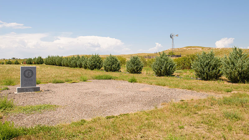
Mile 600: Pole Creek Station
Pole Creek Station, NE
“Life at most of the Pony Express Stations was not exactly luxurious. Sir Richard Burton wrote the following about Pole Creek Station based on his 1862 visit:
‘The hovel fronting the creek was built like an Irish shanty, or a Beloch hut, against a hill side, to save one wall, and it presented a fresh phase of squalor and wretchedness. The mud walls were partly papered with “Harper’s Magazine,” “Frank Leslie,” and the “New York Illustrated News;” the ceiling was a fine festoon-work of soot, and the floor was much like the ground outside, only not nearly so clean.'”
[N.B. The marker is not on the Pony Express Bikepacking Route, but about 4 miles south, on Highway 30 just east of Sidney. The marker location is here.]
“The springs represented the first significant opportunity for obtaining water in a 24-mile stretch of barren overland trail. In 1860, the Pony Express established a line along the Jules cutoff and created a station at Mud Springs. In 1861, shortly before the Pony Express operations ended, a transcontinental telegraph station was positioned at Mud Springs, along with a daily stage coach service.”
“Late in the afternoon, when the evening sky was lemon-colored and placid, we distinguished the dark bulk of Courthouse Rock outlined against the sunset and knew that this day’s journey was ending, as hundreds had ended in years past, within sight of the first great monument of the Oregon Trail. Tomorrow we would imitate the thousands of encamped travelers who took time out for a jaunt to ‘the courthouse’ intending to see for them selves how far away in the deceptive prairie distance it might be. No well conducted tour of the Emigrant Trail, either now or one hundred years ago, would be complete without the inclusion of a pleasure excursion on the side to Courthouse Rock.”
Irene D. Paden, The Wake of the Prairie Schooner, p. 129
Mile 642: Bridgeport
“After Bridgeport, Nebraska, the landscape changed dramatically, from grasslands to spare, dry sagebrush country, and the soil turned from sandy brown to pink. We were entering the magic, pastel geology of western Nebraska that was celebrated by the pioneers and became familiar to Americans through the paintings of William Henry Jackson and Albert Bierstadt. Today the only route along the south banks of the Platte is the two-lane Highway 92, a prime example of the Oregon Trail adapted for modern use by paving the ruts with asphalt, but I was delighted to see that the prospect from the wagon seat was virtually unchanged.”
Rinker Buck, The Oregon Trail, p. 229
Mile 655: Chimney Rock
“On the north side [of Courthouse Rock], between it and the river, a large area of swampy ground makes the going uncertain, and Chimney Rock, the next famous landmark, looms ahead like a beckoning finger to encourage the traveler. . . .
The very loveliness of the scene made for enthusiasm and exaggeration. Some journals record the height of the Chimney as four hundred or even five hundred feet, but the government report, made by Preuss of the Frémont Expedition in 1842, read . . .’the weather is rapidly diminishing its height, which is now not more than two hundred feet above the river . . .’ Jim Bridger explained this phenomenon by the supposition that it had been struck by lightening . . . Local tradition has it that a company of soldiers once camped near by, and, needing a target for their cannon practice, displayed the excellence of their marksmanship by knocking pff about forty feet of the famous old column.
The Chimney Rock stands just across the valley from Bayard, Nebraska, where a one-way bridge tempts the motorist to cross the island-studded Platte and view this great limestone shaft. Here the recurring cholera epidemics of 1849 and 1850 were at their worst, and the Chimney stands guard over the long chain of hasty graves like Nature’s own monument to their memory, visible for miles, a fit symbol of the wild and throbbing romance of the trail.”
[N.B. There is a Chimney Rock Cemetery dating from emigrant times. It is at the end of the short road which goes straight at Mile 655 of the Pony Express Bikepacking Route, where the route makes a right-hand tun. Google Maps shows a trail to Chimney Rock from the cemetery, whereas there is no access from the parking lot at the Chimney Rock National Historic site. Comments on Google Maps note that there is another trail just north of the parking lot. apparently, there are a lot of rattle snakes in the area.]
Irene D. Paden, The Wake of the Prairie Schooner, p. 145-147
Mile 671: Ficklin Station
Ficklin Station, NE
“Did you know Ficklin’s Springs Station in Nebraska was named after Benjamin F. Ficklin, who was the route superintendent, or general manager, for the entire Pony Express route? Ficklin also once owned Thomas Jefferson’s Monticello and was arrested in connection with the assassination of Abraham Lincoln!”
“Ficklin’s Springs Station – This site is reportedly one mile west of Melbeta, Nebraska in Scotts Bluff County. The 1861 Overland Mail Company contract listed the site as an unnamed Pony station, later named for Benjamin F. Ficklin, superintendent of the entire Pony Express route. The site originated as a Pony Express station and later served as a telegraph station and temporary garrison in 1865. In 1871, cattle rancher Mark M. Coad acquired the sod station.”
“The third of the soft stone landmarks is Scott’s Bluff, slightly more than twenty miles from the Chimney. Scott’s Bluff owes its name to an incident of the fur-trapping days. Scott, it seems, was employed by the American Fur Company, and fell sick on his way home from the mountains. . . . [I]n order to make speed, the leader of Scott’s group went ahead with his men, leaving only two to bring Scott down the North Platte in a bullboat. It was agreed to meet at this distinctive bluff.
The boat was wrecked, and there was no way to take Scott along. The two men deserted him, expecting that he would obligingly die quietly where they left him. In fact they reported to their party that he had done so, and the entire company left the bluff and returned to civilization.nThe unfortunate Scott, meanwhile, struggled along toward the assigned meeting place, a distance of some sixty miles. After untold agony of body and mind he arrived to find unmistakable evidence of their departure. Hope was gone. He relinquished his soul to its maker and his outraged body to the wolves; but his bones remained—his bones and some identifying trifles by which they were recognized the next summer anf the whole sordid story was exposed. A memorial tablet has been erected near the spring where he spent his last hours.”
Irene D. Paden, The Wake of the Prairie Schooner, p. 147-148
Mile 689: Robidoux Pass
“The river lapped at the very base of Scott’s Bluff. The wagons must go inland. This was the more difficult because the bluff is not an isolated rocky formation, but the end of a line of hills. Several more of less parallel canyons break through, and of these Mitchell’s Pass, used by the highway, is the best and shortest and lies nearest the river; but it was not passable to the early migrations. Probably it was obstructed by fallen rock and debris. Instead the wagons toiled through Robidoux Pass, the next canyon to the south. . . .
Robidoux Canyon or Pass is reached from the town of Gering. One proceeds first over a decided rise and then down into a large circular valley of loose sandy loam. The emigrants’ columns raised storms of dust through which exposure of Scott’s Bluff showed fitfully until they reached the canyon and entered its obscuring walls. The dust was bad for lungs and equally so for eyes. Helen Carpenter’s little dog became entirely blinded and caused her mistress some bad hours by getting lost in the billowing clouds that smothered the teams. Many stated that they suffered more acutely from eyestrain and from cracked and bleeding lips than from any other cause.
Graves grew thick and thicker.They were no longer approached on paths worn smooth by enquiring emigrants who trudged up from the road to read the crude marker and learn who lay below. Now the travelers were too intent upon their own discomfort to bother . . . And still the westbound families camped near and, unless the smell was offensive, even on the graves in stoical disinterest.
The diarists raved about the distant beauty of Scott’s Bluff. It gave off romance in practically visible emanations, but they seldom mention being comfortable there.”
Irene D. Paden, The Wake of the Prairie Schooner, p. 148-149
Mile 690 - Robidoux Pass
“The emigrants, however, found certain types of country and certain situations to be laborious or dangerous, and these they therefore avoided. Co-called ‘badlands’ where the terrain was nothing but a maze of ravines, had to be detoured. At Scott’s Bluff, for instance, a stretch of land pushed the trail away from the bank of the Platte, and sent the wagons through Robidoux Pass.
George R. Stewart, The California Trail, p. 116
Mile 708: Horse Creek Station
Horse Creek, NE
“This unassuming waterway [Horse Creek] is entwined with the history of the national historic trails. In 1851, it was the location of a historic conference where nearly 10,000 American Indians, representing over a half dozen tribes, met with U.S. government representatives. The result was a treaty that helped to protect emigrants and the trails they used. Later, in 1860, the creek was home to a Pony Express relay station, which was built on its west bank.”
“The overland road entered Nebraska at the dividing line between Gage and Jefferson counties, one-time land of the Otoes, self-styled ‘brothers of the whites.’ We kept about two miles north of the river, stopping now and then to explore some exceptionally deep wheel ruts, when some two miles north of Endicott, came to Rock Creek and the site of the Rock Creek Station.
Here we took a referee’s time out for consideration of a famous quarrel and to look curiously at the setting of a historic gunfight between Dave McCanles, owner of the log station building leased to the stage company, and handsome Wild Bill Hickock.”
[N.B. Ms. Paden also talks about inscriptions by Frémont and Reed (Donner party) among others in a nearby sandstone shelf. The rangers at Rock Creek Station provided this info: “Unfortunately the sandstone ledge was undercut into the creek in the 1970s and was removed around 1984. The original location is on private property and not accessible to the public. Fortunately, there is a brass casting of the carving just outside the Visitor Center at Rock Creek Station State Historical Park.”]
Irene D. Paden, The Wake of the Prairie Schooner, p. 69
The Platte River
“The Platte, in trail days, was tremendously wide and shallow. It was of a temperament entirely different from the tossing flood of the Missouri, the deep and steady Kansas, of the beautiful, benevolent Blue. The Platte itself made excellent going but, beyond the unalterable fact that it was wet, seldom helped anyone else on his way. It furnished no shade. Its water was poor to taste and too dirty to wash in. Its bed was quicksand—not violent in action, but of an insidious sucking variety that tugged at the boots of those who dared to wade, pulled at the lunging horses and slowly dragged down any wagon unfortunate enough to stall in midcurrent. Its silvery, shallow waters flowed with deceptive swiftness along the hardly noticeable declivity of its course, spreading over an incredible breadth of territory. Some of the emigrants credited it with a width of two miles as it neared the Missouri. One, who saw it in extreme flood, believed it to be three. It existed for and with itself. That stage drivers said that it didn’t even overflow, to enrich the valley, but merely saturated its quicksand banks so that they rose with the current and retained the flood waters within its channel. Emigrants who saw its ‘mad, majestic course’ in flood said it looked higher than the road.
It could not be ferried for lack of depth. It was difficult to bridge beyond any means available to the emigrants, and it was dangerous to ford. Its shining waters carried such a burden of suspended earth that the disgusted travelers accused it of flowing bottom-side up, and a child, once swallowed in its swift and turgid flood, was lost to sight even though the water might be shallow enough for rescue.”
“Rock Creek station was established along the Oregon-California Trail in 1858 to sell supplies and other services to the emigrants. The station subsequently served as a relay station for the Pony Express, and finally as a stage station for the Overland stage. To the northwest of the old station site is the finest stretch of pristine trail ruts in southeastern Nebraska. These ruts, which cover 1600 feet, are quite dramatic in appearance.”

Sometimes this stretch is referred to as “Nine Mile Ridge.” The stone marker was erected by the State of Nebraska in 1912. Located at https://goo.gl/maps/EHArEhZmXwpZRR4EA.
A freight train consisting of eight wagons loaded with hardware for Denver, was attacked Sunday morning, August 7, 1864, by a party of Cheyenne and Arapahoe Indians. Five men were killed instantly, a sixth was mortally wounded, and the wagons were burned. (Brown, 2007) The bodies and smoking wagons were found by two young couples out for a Sunday morning ride from Thirty-Two Mile Creek station and on Monday morning Overland Stage Line employees from the station arrived. The wounded teamster was able to give a few details of the attack before he died. The men were buried beside the trails 140 yards south of the OCTA marker. This is the only known burial site of white men who met death in Adams County due to hostile Indian activity. The Nova-Color OCTA marker was installed in 1996 on the south side of the road at the edge of a broad and deep ditch. Franzwa’s Maps of the Oregon Trail shows ruts southeast of the markers, but with the installation of a center pivot irrigation system several years ago, they are no longer visible. The next image shows the flat marker indicating the burial site.
The trail angled northwest across this steep drainage and must have been a hard pull after rains. This quarter section has been cultivated for decades and swales are not visible. D. W. Kingley, Jr. and Will Locke flew the trail in June in 1985 looking for faded color in the crops due to soil compaction from the trail traffic, but no crop color contrasts were observed. In steeper areas that had been left in native pasture swales were clearly evident. This marker was erected by the Niobrara Chapter of the DAR in 1912.
At the stage station marker look west across the small valley of Thirty-Two Mile Creek to the pasture and you will see several parallel swales climbing west out of the valley. Low angle light of early morning or late afternoon places these swales in shadow and they are easier to see. Light snows will make the swales stand out and during a thaw following deeper snows, snow will linger in the swales and one can see them clearly enough to count. Binoculars would be helpful as the “swales” are a half mile distant. This area must have been one of the tougher pulls of the Little Blue/Platte Valley trail segment. The first problem was the steep descent down into the valley. The brake mechanisms on the wagons were not very effective and the weight of the wagons would have pushed hard on the oxen. They could have run a pole through the rear wheels to provide additional braking action. Crossing the creek would have required the first wagon travelers of the season to dig ramps on both banks and perhaps to double team. Re-digging the ramps would be required after periods of high water. Once the pull out of the little valley was accomplished, the going was smooth until the crossing of the West Branch of Thirty-Two Mile Creek. Elm Creek Station was built by the Holladay Stage Line as a replacement for the Lone Tree Station which was burned during the Indian Raid of 1864. The marker was erected by ACHS in 1973. The granite stone came from the foundation of the old Hastings Post Office.
This location is almost exactly in the center of Adams County and the Thirty-Two Mile Creek Station name indicates the distance to Ft. Kearny. Russell, Majors, and Waddell formed the Leavenworth and Pikes Peak Express company in 1859 and most likely constructed the Thirty-Two Mile Station that year. Samuel Word kept a diary of his 1863 trip across the plains and the following words are from May 28: “We are now 32 miles from Fort Kearny. Am most anxious to reach Kearny for I expect to hear from home. Have just returned from a ranch close by, where immigrants and settlers to the number of 100 are congregated engaged in a genuine old-fashioned back woods dance. . . . The ranche was about 12 by 14 feet square covered with sod. . . . The house had what it would hold, the rest stood outside. . .many of the men were drunk from rifle whisky sold them by the proprietor of the ranche. His grocery was in one corner of the room. I left them dancing.” (Word in Renschler, 1997)
This section of the trail falls between branches of Thirty-Two Mile Creek and is very smooth. The inscription on the granite stone reads, “Oregon Trail Marked by the State of Nebraska 1912.” Scout troop 192 helped erect this marker.
The trail moves from southeast to northwest on gentle ground between two branches of Thirty-Two Mile Creek. Soon the travelers will descend to Muddy Station on the West Branch of Thirty-Two Mile Creek. The inscription on the historical marker reads:
This area was possibly the driest and windiest section of the pull from the Little Blue to the Platte Valley. Summit Station may have been established in 1860 for use as a Pony Express Station. Joe Nardone (2008) refers to it as an “added station”. The station was abandoned after the Indian raids and never rebuilt. Frank Root in The Overland Stage to California (in Renschler, 1997)wrote:
Just west of Kenesaw the trail jogged sharply west and then north to avoid a lagoon that is hardly visible today. John Klusman, while taking a break from planting in May, 2008, explained that the land had been leveled and drained in such a way that the lagoon that had previously been so prominent was no longer visible. The writer jogged this section of the trail in the late 1970s and recalls a large lagoon that obviously would have caused the wagons to detour. The goal was to get to Ft. Kearny with as little wear and tear on stock and equipment as possible; they were not going to get bogged down in a lagoon to save a mile. This marker was erected by the State of Nebraska in 1914.
The following lines rely extensively on the article by Randy Brown in the Spring, 2007, issue of Overland Journal, titled The Grave of Susan C. Haile. When I first visited this area in the late 1960s with Boy Scouts, it was generally known as the “Lone Grave.” Randy Brown writes, “Most assuredly, however, when Susan Haile died in 1852 hers was not a lone grave. This was in the midst of the ‘cholera corridor’, . . . .” Most likely there were dozens even hundreds of graves along the Thirty-two Mile Creek/Platte River Valley stretch, but we know only the Susan Haile grave location. We know of the Haile grave because of the existence of a headstone. Intriguing legends and questions accompany the Haile story. Who was she? How did she die? How was a gravestone transported to the spot?
The Nebraska Historical Marker explaining the Susan Haile story was erected by the Kenesaw Centennial Committee and the Nebraska State Historical Society. The smaller marker is inscribed, “In Search of Pony Express Station Marker. Sand Hill.” It was dedicated June 8, 2002, by James Stretesky, Adams County Bank, Dorlene and Vern Hunt, Family of Leonard Osler, Pony Express Trails Association, and Joe Nardone, Historian.