“From West of Casper, WY to outside of Sacramento, CA free camping on public lands can happen almost anywhere you can find a place to put your sleeping bag down. I wouldn’t necessarily suggest a hammock as there aren’t very many tall things to tie off to out in the high desert.
“Emigration Canon is one of the deepest and narrowest of them all; its cliffs are relieved by no beauty of form or colour, they are stern, grim, unpitying ; the snow higher up looks warmer. . .”
William Chandless, Chandless, W. (1857). A Visit to Salt Lake, p. 130
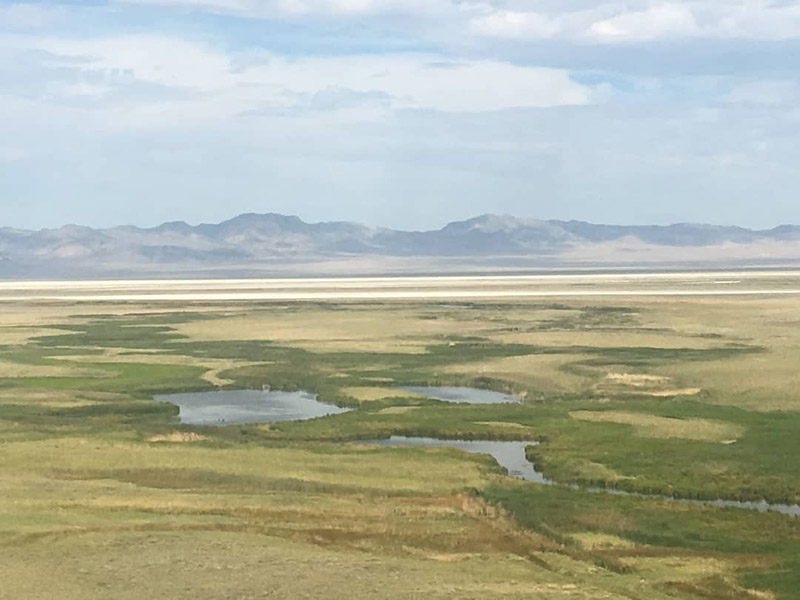
Mile 1235-1311: Henefer to Mountain Dell station
“Beyond [Henefer Creek’s] headwaters, the great wagons rolled and thundered through Pratt’s Pass on the summit of a low divide.Down another steep hill the wagons pitched while all hands and the cook held back on ropes and on the wheels; along the bed of the tiny streamlet, crossing and crisscrossing it for two or three miles down to East Canyon with its steep watercourse known variously as Canyon, east canyon, or kenyon Creek. Here they really learned the meaning of ‘trouble.’
Small shallow East Canyon Creek had to be forded ten or more times; the trail was crooked beyond reason and think with amputated willow stubs, testimony to the herculean task accomplished by the Reed-Donner party in forcing a passage through mountains at this point in 1846. The Mormons, traveling in their footsteps a year later, accomplished the thirty-five mile trek from Weber River to Salt Lake Valley in three days; but they recorded that it took the Donner party sixteen days of hard labor to win through the valley. For years the cut willow stubs remained, and the animals baptized them with blood from torn hoofs and gashed legs.
From East Canyon the trail led up a ravine worn down by a narrow and precipitous creek full of bottomless mire and huge boulders ‘over which mules and wagon wheels had to be pulled or lifted constantly.’ . . .
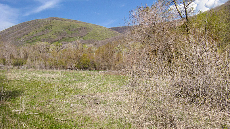
When they reached the top of this four-mile climb the wagons were at the highest elevation of the entire journey so far, and about two thousand feet above the point where they had entered East Canyon. Here, on the fir-crowned summit of Big Mountain, the migrating Mormon columns had their first view of the promised land.
A mile and a half down, and down. No animals were left on on the wagons but the faithful wheelers remaining to hold up the tongues. Every available man held back on a rope. By ’49 the timber had been cut for the building of Salt Lake City and the caravans twisted here and there between the jagged stumps down to a small, sheltered hollow known as Mountain Dell. It was a lovely meadow, but miry. The wagons often celebrated their return to the horizontal by stalling in the mud with promptness and precision, and the tired travelers, admitting that they were sunk, gave it up for the day, camped, and fought mosquitoes.”
Irene D. Paden, The Wake of the Prairie Schooner, p. 295-296
Mile 1280: Echo City, UT
“Exhibit A is Pulpit Rock, where, so the townspeople told us, Brigham Young stood to preach yo his followers in 1847 on the way to their new home in the Salt Lake Valley.”
[N.B. The historical marker is in the town, less than a mile from the Pony Express marker just before town. Also note, the Pony Express Bikepacking Route left the original Pony Express route around Mile 1232 (just past the Bear River station), and rejoins it in Echo.]
Irene D. Paden, The Wake of the Prairie Schooner, p. 294
Mile 1285: Henefer, UT
“For anyone riding through Utah, be forewarned that the c-store in Henefer is currently dead. There is an ice cream shop attached to it where they’ll refill your bottles.”
[N.B. the note refers to Grump’s Grocery Store, noted on the Pony Express Bikepacking Route.]
“From the confluence of the Echo Creek, the Weber flows six miles through velvety meadows starred with wild flowers and then slips into the mouth of a rock-bound canyon where, in trail days, the wagons could not go. . . .
Somewhere in the six-mile stretch preceding the canyon mouth the emigrants had to get across the Weber, and the sooner the better, for it picked up small tributaries along the way. It is definitely a mountain stream, and the early parties—those, for instance, who arrived before the end of June—found it dangerous. . . .
The emigrants left Weber River near the mouth of the unfriendly canyon, and stayed with timid little Henefer Creek its few feeble miles up through the rough hillside.”
Irene D. Paden, The Wake of the Prairie Schooner, p. 294-295
Mile 1285: Weber/Echo/Bromleys/Hanging Rock Station
“James E. Bromley, division superintendent for the run from Pacific Springs Wyoming to Salt Lake City, settled at the mouth of Echo Canyon in 1854. He did not obtain a cash entry patent, however, until June 20, 1874 (Cert. No. 1127). It is reported that the station house, built at the base of Pulpit Rock, had rock walls 26 inches thick. The authors disagree. Located on the Pete Clark property, in Echo, Figure 7, the visible remains of the foundation of the station house have been located and mapped by the authors. The walls average thickness is much less. The facilities of Weber Station provided the services of a general store, inn, saloon, blacksmith shop and jail. A hotel was built later. . . .
“About two miles west of Weber Station, the mail was transported across Forney’s Bridge on the Weber River. The bridge was constructed prior to June 1858. From this location, the Express riders traveled up Bachelors Canyon to the top of Dixie Hollow. When the crossing was unsafe or the canyons were snowed in, the rider could go on down the valley to the Brimville Emergency Station or Henneforville (SW1/4SE1/4 Sec. 4, T. 3 N., R. 4 E. now Henefer) and around by Little East Canyon to Dixie Hollow. The pioneer immigrants came part way down Dixie Hollow, turned right, crossed the ridge, and then went south into East Canyon. By the time of the Express, the road was built all the way down the hollow to just south of where it opens into East Canyon. The 1858 wagon route map of J. H. Simpson shows East Canyon Creek to be Snyder’s Creek.”
[Note: Bachelor Canyon, now South Henefer Road, runs into private property someplace south of Henefer]
“Before heading out to ride the Salt Lake City to Sacramento section of the Pony Express route I wanted to verify the single track option leading into Salt Lake City. Unfortunately, it’s not ride-able. It’s hardly hike-able. Reminded me of the TourDivide and the section where you walk your bike through a river that’s basically snow melt and take a hike up a muddy wall with a bike in tow. Lots of deadfall. Lots of rocks. Lots of mud. Amazing beauty in every direction, though.
The hike-a-bike will remain on the route for those who wish to keep as true as possible to the original route. I aim to have two GPX files. One that includes a handful of hike-a-bike sections that stays true. Another GPX file that bypasses those hike-a-bikes for easier, sometimes paved, alternatives.
For this section there is a paved alternative that happens to also be a favorite for local road cyclists. Drivers through here are aware of this and have been courteous to those cyclists every time I’ve passed through. The decision on which route to take, and the level of adventure that you’re looking for, is all yours!”
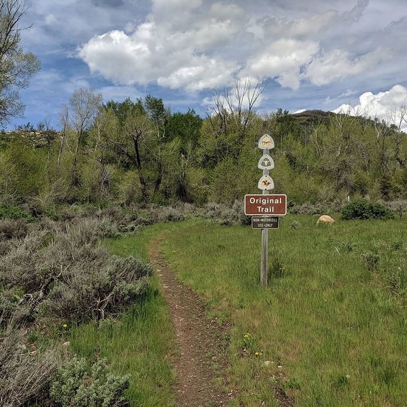
Single track, Big Mountain Pass, UT
[N.B. the paved alternative seems to be Highway 65; the cutoff is just before Mile 1299]
“Pony’s clear from Henefer to at least Ibapah. Can’t vouch for Wyo. Be careful if you decide to take the singletrack off of Big Mtn Pass in Utah. They made the lower reaches by Mtn Dell Reservoir more MTBish.”
Borby Kennedy on Bike The Pony Express , 5/5/2020
Mile 1304: East Canyon/Dixie Hollow/Dixie Creek/Bauchmanns/ Snyder's Mill Station
“Ten and one-half miles from Weber via Bachelors Canyon [blocked by private land] or about 13 and one-half miles from Weber via Henefer.
“East Canyon Station, currently inundated by the East Canyon Reservoir, is located in Section 10. Often referred to as Snyder’s Mill this error may be derived from information gleaned from Captain Albert Tracy’s Journal. It was at Snyder’s house, in Section 19, along the road from Parley’s Canyon that Tracy stayed the night. Further confusion occurs since Snyder’s Settlement (Snyderville) and Snyder’s Sawmill are shown as located in Section 31, about 3 miles south of Snyder’s House. Samuel Snyder had settled at this location in 1853.
“Following its use as a mail station, travelers and sheepherders utilized the area and the neglected buildings. A sheep corral and grave mark the site. . . .
“Facing down East Canyon, the Mormons built a fortification about four and one half miles south of East Canyon Station. The structure was built for a holding action against Johnston’s Army. A site just to the north of here has been called Bauchmanns, but evidently this site is also in error. The pioneers traveled south of Bauchmanns about two and one half miles and turned northwest up Camp Creek or what is now called Little Emigration Canyon. By the time of the Express, a shorter road had been constructed up Monument Creek, or as it is now called, Dutch Hollow. Traces of this road are still visible on the ground.”
[Note: The road up Monument Creek is now Highway 65. The XP Bikepacking Trail follows the Emigrant Trail to Mormon Flat, then up Little Emigrant Canyon. The turnoff is just after the station.]
“[From Little Mountain] Seven miles yet intervened between these recklessly intermingled people and the City of the Great Salt Lake, most of them in narrow, rock-bound brushy Emigration Canyon.
Between Emigrant Canyon and the city the wagons slowly filed past the spot, now called Journey’ End, where Brigham Young spoke the well remembered words, ‘This is the place.’ Just ahead the ‘City of the Saints’ spread before them, three miles in each direction.”
[N.B. This area is now called “This is the Place Heritage Park.”]
Irene D. Paden, The Wake of the Prairie Schooner, p. 297
Mile 1311: Mountain Dell Station
Mountain Dell Station, UT
“Pony express stations were usually not just Pony stations. Such as was the case with Mountain Dell Station, near the head of today’s Little Dell Reservoir. It served as a trading post, mailstation, and inn. The station was run by Ephraim Hanks, a jovial, sandy haired frontiersman with a grizzled beard and smiling mustache. Ephraim’s stepson worked as a Pony rider and his “plural wives” served meals (on at least one occasion, boiled badger) to well heeled stage passengers!”
[N.B. “The exact location of which has been much debated. It stood a distance up the slope from Little Dell Reservoir, but neither study of contemporary accounts nor an extensive archeological dig conducted by researchers from Brigham Young University has answered the question of the actual station site. . . . Ephraim Hanks [who ran the station] was also reported to be a leading figure among the Mormon Danites, or Destroying Angels. More info about hanks and the station here.]
“Big Mountain lies eighteen miles from the city. The top is a narrow crest, suddenly forming an acute based upon an obtuse angle. From that eyrie, 8000 feet above sea level, the weary pilgrim first sights his shrine, the object of his long wanderings, hardships, and perils, the Happy Valley of the Great Salt Lake. The western horizon, when visible, is bounded by a broken wall of light blue mountain, the Oquirrh, whose northernmost bluff buttresses the southern end of the lake, and whose eastern flank sinks in steps and terraces into a river basin, yellow with the sunlit golden corn, and somewhat pink with its carpeting of heath-like moss.”
Richard Burton, The City of Saints, p. 190-191
Mile 1316: Mountain Dale/Mountain Dell/Big Canyon/Hanks Station
“A vandalized monument in the NW1/4 of the NW1/4 of Section 36 presently marks the location of the assumed station site. . . .
“Upon checking the USGS quad map, it can be seen that Little Mountain Summit is west of the presently marked station site, in section 36. It should be noted that the roads do not go over Little Mountain, but do go over Little Mountain summit. The 1881 survey plat shows the currently marked location as Cook’s house and barn. West of the summit, however, in Section 33 (See Figure 12) the surveyor records a cabin at the mouth of what is now named Freeze Creek. This site, incidently, is about equidistant between the Salt Lake House and Wheaton Springs. It should be also noted the name “Mountain Dale” appears on the 1861 Mail contract. Granted, that Mountain Dale has been a long standing name in its present geographic location, but could Mountain Dale, the name given to the Hanks station site, have been unknowingly changed by later historians and writers?”
[N.B. The following ride report from Tim Tait is written from west to east]
“I did a day trip from Fish Springs Wildlife refuge (mm1477 on RWGPS file) to Salt Lake City just recently. Here’s my notes on the section . . .
From Fish Springs to Highway 36 is reasonably smooth. I spoke to the ranger at Fish Springs and he mentioned the road was just regraded in October, so it only had a few months of traffic on it. It’s a surprisingly high trafficked area so I suspect it will return to washboards in the next few months. Lots of clay based areas so rain could put you at a stand still, depending on what time of year you ride. I rode two days after a small storm and roads were already dry. From highway 36 over to highway 73 were the worst washboards I’ve ridden in a while.
Keep in mind these areas are OHV playgrounds, so you will run into a good amount of Tacomas/Jeeps/ATVs in these areas. On a sunny weekend during early recreation season (as I hit), you’ll be in a dust cloud of big trucks. Plan accordingly.
It was 24 degrees in early March when I started at sunrise from Fish Springs, and possibly mid 50’s at the finish around SLC. I did it on 4 liters, but that’s b/c it was cold and the desert has slowly turned me into a camel. It’s probably an 8-9 liter section in hotter conditions.
I rode a Hakka MX on 650/47’s Specialized Pathfinders. Worked just fine on this section, but I wasn’t fully packed down and this isn’t the roughest of sections. Bring your aero bars, and tires with good side wall casing. Lots of sharper, larger gravel sections.
Make sure to take some time to cruise around Fish Springs (as long as it’s not bug season). It’s really breathtaking.
As mentioned by others, you can’t camp in Fish Springs but there is a small little gravel pit to camp at right in between the refuge lines [pictures here]. It has some camp fire rings and is protected from the wind (which you’ll want out in that area).
What the Utah west desert lacks in elevation, it makes up for in wind, heat, quick forming storms and limited shelter. It’s pretty damn unforgiving. I’d avoid riding this between June-August IMO. Even with a night riding strategy, there’s just no shade/shelter…”
“A little video I made of the first two days on the Pony Express trail from Salt Lake City to Callao, Utah. Unfortunately, due to time constraints that were too tightened for comfort by weather I had to call my ride to Sacramento on Ibapah, UT, right at the Nevada border.
I had hoped to document via video the whole route from Salt Lake to Sacramento and scout some more challenging options for the route. I am planning another trip later this summer, so I might still get that chance.”
“This station, similar in construction to Brigham Young’s Beehive House, stood where the Salt Lake Tribune Building now stands, at 143 South Main. Because of recent street beautification, the monument has been moved to the south. According to Sir Richard Burton, the station was one of the better facilities along the Overland Trail for food and lodging. Horace Greeley and Mark Twain were among the guests.”
“Constructed of adobe, the station apparently was only used for a short time. In later years, the structure was covered with wood siding and a false front and re-converted into a business. More recently it served as a garage. . . .
“Trader’s Rest was located on State Street about two miles north-northwest of Union Fort. The area was called Lovendahl’s Corner after Swen Lovendahl, an early settler.”
“Rockwell’s Station was named after the operator Orin Porter Rockwell. Rockwell earlier served as Brigham Young’s bodyguard (1830’s) and was a Danite (member of the Mormon protection group, organized in Missouri to protect against terrorist activities). On September 9, 1850, Rockwell was appointed Territorial Marshall. The 1856 survey plat shows the old road missing the location thought by some to be the station (just across from the prison). It plats a house and springs about three quarters of a mile south. This had been the location of Rockwell’s Station.”
Mile 1382: Dugout/Joes Dugout/Joe Butchers Station
“In conjunction with the Express and stage operation, Joseph Dorton operated a small grocery store. Clients were generally the soldiers from Camp Floyd. He also built a two-room brick home and log barn and provided a dugout for an Indian boy helper. Besides well water (Photo 16), water was hauled from Utah Lake and sold for twenty-five cents per bucket. Use of the station after 1861 is unknown. It may have continued in use as a stage station.
“The station was located within John Carson’s Inn in Fairfield and saw use for both the Express and stage travel. The adobe building was built in 1858. It is still standing, has a wooden facade, and is open to the public as a Utah State Park. It was operated by the family until 1947. Such personages as Horace Greeley, Mark Twain, Sir Richard Burton, Porter Rockwell, Bill Hickman, and General (then Colonel) Albert Johnston stopped at the inn.
“In 1885, John Carson and his brothers, along with John Williams, William Beardshall and John Clegg, established Fairfield and Cedar City Fort. The latter was constructed as a private protective compound. It was adjacent to Fairfield that Camp Floyd, named for Secretary of War John B. Floyd, was established in November of 1858. Camp Floyd was the second military establishment in Utah and was commanded by Colonel Albert Johnston. (The first military reservation in Utah was established in Rush Valley, near present day Stockton, in 1853, by Colonel Steptoe. Its objective was to establish a military route to California and to investigate the Gunnison Massacre.)
“Captain Simpson, Senior Engineering Officer at Camp Floyd, designed the overland stage route from Salt Lake City to San Francisco.
“With a population of 7,000 — 3,000 of which were soldiers — Fairfield was the third largest city in the territory. Boasting 17 saloons, wild Fairfield catered to soldiers and the army payroll.”
Mile 1403: East Rush Valley/Pass/Five Mile Pass Station
The first Pony Express station in Tooele County, UT, is located in Rush Valley while heading west from Utah County toward Faust on Faust Road, which is also the original Pony Express Trail. Faust Road begins at Five Mile Pass on the county line between Tooele and Utah Counties, and ends at Faust near Vernon. East Rush Valley Station, built as a dugout, was listed by Howard Egan as being very active even though it is not identified as a contract station. The military road ran just to the south of the station, toward Vernon, and is still quite visible today.
Also called “No Name” or Five Mile Pass, this station’s stone monument out on the flats at the site is typical of those found at the location of Pony Express Stations all across western Utah. Not much is known about the structure which was here or its use. It was not listed as a Pony Express contract station. The monuments were constructed in the late 1930’s by the Civilian Conservation Corps (CCC) and the workers were stationed at a CCC camp at Simpson Springs, and left a legacy of monuments, trails, and other improvements around the region. Each monument featured two bronze plaques. One was a circular Pony Express Rider plaque, sculpted by A. Phimster Proctor. The other was rectangular, and gave information describing the nearby station. The plaques were provided by the Utah Pioneer Trails and Landmarks Association. Most of the bronze plaques have been stolen, but in recent years the Utah Division of the National Pony Express Association has been working with the BLM to maintain these markers and to replace the round horse-and-rider plaques. . . .
Fike and Headley locate this dugout station ten miles southwest of Camp Floyd. Although the 1861 mail contract did not identify East Rush Valley as a station, it apparently received a lot of travelers from the military road just south of the site. Local people also knew the station as Pass and Five Mile Pass. In 1979, a depression identified the site where the dugout stood. Several other sources also list East Rush Valley as Pass Station, the Pass, and Five Mile Pass, located between Camp Floyd (or Fort Crittenden) and Rush Valley. In 1965, a monument with a plaque donated by the Daughters of the Utah Pioneers marked the station site. http://www.nps.gov/parkhistory/online_books/poex/hrs/hrs7a.htm#110
Mile 1403: East Rush Valley/Pass/Five Mile Pass/No Name Station
“East Rush Valley Station, built as a dugout, was listed by Howard Egan as being very active even though it is not identified as a contract station. The military road ran just to the south of the station, toward Vernon, and is still quite visible today. When in early 1861 Colonel Johnston left the Union to fight for the Confederacy, Colonel Phillip St. George Cook became the new post commander [at Fort Floyd]. The name was changed to Ft. Crittenden, but by May of 1861 the Fort was abandoned and ordered destroyed. By September of that year, Fairfield’s population had dwindled to about 18 families.”
“‘We built a log cabin, the roof was dirt, the floor was dirt. A wagon cover made a carpet. The window was glazed with a flour sack. The door was a blanket. The table an endgate of a wagon. The first stage west of Salt Lake brought Mrs. Faust to this stately mansion where she lived nine months without once seeing a woman!’ Henry Faust, station keeper.”
“Faust is a settlement located in central Tooele County, Utah. It was founded by Henry J. Faust (born Heinrich Jacob Faust), a Mormon immigrant from Germany. In 1860 he managed Faust Station on the Pony Express trail. In 1870 Henry Faust and his wife moved to Salt Lake City. Faust has been used by the Union Pacific Railroad to house workers on the site. The area is popular with campers, mountain bikers, off road vehicle enthusiasts, and hikers during the summer months. Henry J. Faust was an ancestor of Mormon apostle James E. Faust.”
Mile 1411: Rush Valley/Bush Valley/Faust/Doc. Faust's/Meadow Creek Station
“Although identified in the 1861 mail contract as Bush Valley, it is apparently a typographical error or was copied as a result of a misinterpreted hand-written contract. This station was established originally by George Chorpenning in late 1858. Within Utah (present boundaries), Chorpenning had built two relay stations, the one at Rush Valley called Meadow Creek Mail Station and the other at Smith Springs (Fish Springs). There is a question whether the stone building still standing at Rush Valley is the station house. The 1871 survey plat names this building Faust’s House, while the survey notes call it Faust’s Station. This building also has been called the old Fletcher house. We are told the remains of a depression marked the structure known as the station house. It was apparently evident for many years to the east and north of the present structure.
“‘One of ‘Doc’ Faust’s most pleasant remembrances while living at the station was the visit of Horace Greeley, editor of the New York Tribune, who was on a trip across the continent. Knowing that Mr. Greeley would very likely bury himself in books and not wish to carry on conversation, Mr. Faust took great care to see that all the tallow candles were hidden, leaving the house in darkness. Mr. Greeley, unable to read, then made a delightful companion for the remainder of the evening with interesting accounts of his travels.’
“In 1870, Doc Faust moved to Salt Lake City and became engaged in the livery stable business. He later traded his ranch to O.P. Rockwell for 80 head of cattle.
“The field notes (survey records) of A. D. Ferron of October 1869 stated that there were two telegraph lines (from Salt Lake City) meeting at this location, one via Tooele and one via Camp Floyd to California.
“The property, which includes the stone building and a cemetery, is under private ownership and is closed to the public. The monument north of the area, is misplaced and the log structure across the highway to the east is often referred to as ‘the original station.'”
“Burial plot. Enclosing graves (west side) of two men and a child emigrants of the early eighteen sixties.
“Original wall erected in 1888, By Mrs. Horace (Aunt Libby) Rockwell to shelter graves of her beloved dogs. 1. Jenny Lind, 2. Josephine Bonaparte, 3. Bishop, 4. Toby Tyler, Companions in her lonely, childless vigils here about 1866 to 1890.
“Sometime between 1860 and 1870, Horace Rockwell and his wife Elizabeth “Libby” Rockwell moved to Skull Valley, a 40-mile long valley in what is now Tooele County, Utah. They operated the Pony Express station known as Point Lookout then continued living on the property in a log cabin built by stage workers after the station had closed. They became horse and cattle ranchers and garnered a reputation as ‘rough frontiers folk’ and “two strange characters.’ Over time, the pair came to be known affectionately as Uncle Horace and Aunt Libby.”
Mile 1421: Point Lookout/Lookout Pass/Jackson's Station
“Originally, Lookout Pass was identified by Simpson as General Johnston’s Pass. The mail contract called it Point Lookout. From the top of the pass one can look west into the desert at what was to become known as Piute Hell. In May 1860, the Pah Ute War began, caused apparently because of white encroachment and depredations. For a short time, the Express was completely shut down (June-July). This ‘war’ was finally settled after the Civil War when soldiers were sent west to quell the Indian uprisings.
“An Egan employee, Fredrick W. Hurst, chronicles a station near the pass as being ‘Jackson’s Station’ in Brush Hollow. By 1876, the survey records show the site to be settled by Horace Rockwell (O.P. Rockwell’s brother) and his wife, Libby (See Figure 20). Reportedly in 1885 and since about 1870, the Rockwells occupied a small log house, possibly the old station house. A small cemetery plot, to the south, with iron railings apparently contains the remains of Rockwell’s pet dogs. No other physical remains can be found at the site.”
Mile 1429: Government Creek/Davis Station/Government Well Station
“There is some doubt as to whether the structures at this location were used by the Pony Express. There is record of the army digging a well here for an outpost, and it was mentioned in an interview with one of the stage drivers in the Salt Lake Tribune. A telegraph station was established here in late 1861 and operated by David E. (Pegleg) Davis. Its location is reflected on the 1875 cadastral plat. The transcontinental telegraph was in operation through this area until 1869 when it was moved north to parallel the new transcontinental railroad.
“Government Creek Station is neither mentioned in the 1861 contract nor in Egan’s book. Until appropriate investigations are complete, questions will remain to plague the researcher. Why is there such a gap between Point Lookout and Simpson Springs when a mountain pass exists and on either side; stations are spaced about eight miles apart? Why build a telegraph station here when a spur line could have been built to O.P. Rockwell’s (Porter Rockwell’s ranch was just a short distance to the south and a similar spur was used at Deep Creek to Egan’s Ranch)? Why was a telegraph station built here when at Point Lookout or Simpson Springs conditions for grounding the single wire were better (more moist the soil the better the ground).
The logic of building a telegraph station at Government Creek bears a closer look. A single wire telegraph would carry as far as 250 miles (with enough batteries) so that booster stations in between were not necessary. Davis Station is about 80 miles from Salt Lake and about 100 miles from Deep Creek. Therefore, technically, placement at this location was not necessary. Also telegraph stations could be spliced in anywhere along the line with the use of a lead wire from the main line to a sounder, two batteries, a key, and a ground wire. Was there any reason for establishing a telegraph station here at all unless the buildings were already present? This suggests, therefore, that the buildings were already there and possibly used by the Express. The foundations of two structures remain evident at the site.”
“Simpson’s Springs, which was named after explorer Captain James H. Simpson. Excellent water made this location a great spot for a Pony Express Station. The current station building at the site is a replica built in 1975 by the Future Farmers of America.”
[Addendum: “Simpson’s Springs Pony Express Station is lonely. Located on BLM land in western Utah you have to want to come here. There is a small, rustic BLM campground nearby, but what’s most abundant is solitude.” –Posted on the Pony Express National Historic Trail Facebook page, 3/27/18]
[Addendum 2: “Simpson Springs bears the name of explorer Captain James H. Simpson, a Camp Floyd topographical engineer, who stopped here in 1858 while laying out an overland mail route between Salt Lake City and California. The availability of excellent water made Simpson Springs one of the most prominent stations in the West Desert.” Pony Express National Historic Trail Facebook page, 2/21/20]
“It gets legendarily hot out there. I’ve ridden there in March when it was already 80ºF in the West Desert. So much better from late September on. There’s seasonal water access at Simpson Springs campground with a pump and such, but it’s never been working when I’ve gone through.”
Mile 1436: Simpson Springs/Pleasant Springs/Egan's Springs/Lost Springs Station
“Simpson Springs became one of the most prominent stations in the West Desert due to the availability of excellent water. Chorpenning, living in a Sibley tent first developed the area in 1851. A permanent structure was constructed, with others soon to follow. Chorpenning’s buildings were probably used by the Overland Mail and the Pony Express. The 1873 survey plat places the Express station about 300 feet west of the present reconstructed building. Probably more than one structure was utilized for the Express and stage at the location; depending upon the operator’s preference for family housing. Aerial remote sensing, using infrared film, shows what might be the location of a structure just north and east of where the springs originally flowed and west of the present reconstruction.
“After demise of the Pony Express and the Overland Mail activities, Simpson Springs utilization decreased. It wasn’t until the 1890’s when mining activities around Gold Mill increased that Simpson Springs again became a popular trail stop. The rock station was refurbished and used by the Walters and Mulliner Stage Co. BLM’s reconstruction of the building is based on oral accounts and excavations. The work under BLM direction, was completed in 1975 by the Future Farmers of America.
“In the 1890’s several other buildings were also constructed including the Dewey and Clara Anderson home destroyed by fire about 1957. According to an informant, Clara Wright Anderson died during childbirth either while the house was being constructed or shortly thereafter. That date was May 14, 1895. Other buildings existed in the area including a log grocery store apparently located southeast of the Anderson home.
“A Civilian Conservation Corp (C.C.C.) camp was built west of the site in the 1930’s; its remnants are evident today. BLM has developed the area and installed camping and interpretive facilities.”
“Passing out of Skull Valley, we crossed the cahues and pitch-holes of a broad bench which rose above the edge of the desert, and after seventeen miles beyond the Pass reached the station which Mormons call Egan’s Springs, anti-Mormons Simpson’s Springs, and Gentiles Lost Springs.
Standing upon the edge of the bench, I could see the Tophet in prospect for us till Carson Valley: a road narrowing in perspective to a point spanned its grisly length, awfully long, and the next mail station had shrunk to a little black knob. All was desert : the bottom could no longer be called basin or valley: it was a thin fine silt, thirsty dust in the dry season, and putty-like mud in the spring and autumnal rains. The hair of this unlovely skin was sage and greasewood : it was warted with sand-heaps ; in places mottled with bald and horrid patches of salt soil, while in others minute crystals of salt, glistening like diamond-dust in the sunlight, covered tracts of moist and oozy mud.”
Richard Burton, The City of Saints, p. 454
Mile 1444: Riverbed Station
“The station was built in an old riverbed formed by evaporation of Lake Bonneville. The water contained in the northern portion of the great inland sea had a greater surface than the southern portion. Consequently more evaporation occurred in the northern part. Water seeks its own level and in this case, the water was squeezed into a low channel between two mountain ranges on the east and west. Here the movement of the water from south to north dug the river as the lake receded.
“Because of flash flooding, little evidence today remains of the station’s existence. . . . It is mentioned that it was hard to keep a station keeper at Riverbed because the area was supposedly haunted by ‘desert fairies.’ A monument was established at the site by the Civilian Conservation Corp in 1939 or 1940.”
“Water for Dugway Station had to be hauled from Simpson’s Springs. Although three wells were dug over several years, one reaching a depth of 120 feet, no water was found. Noted as a “substation” by Horace Greeley, nothing very permanent was ever constructed at the site. In 1860 a shelter was placed over a dugout and an adobe chimney installed. In the 1890’s, the location was utilized as a halfway stop by the Walters and Mulliner Stage Co. on the route between Fairfield and Ibapah. A monument is located at the site today (See Photo 28). Physical evidence at the station site is limited to a disturbed area containing poorly preserved metal objects (possibly from a corral or blacksmithing area north of the wash) and some concentrated stone.”
“Also known as Butte, or Desert Station, it was named for the black basalt outcropping just to the north of the road and the monument. Sharp says it was also known as Rock House. Initially called Butte or Desert Station, the rock structure was constructed as part of trail improvements undertaken by the Overland Mail Company after acquiring the Express in July 1861.
Little is known about Blackrock station, or its usage possibly due to it being a non-contract station. A structure of native black stone was apparently built here in 1861, while other structures in the area are suggested. Reconnaissance and infrared photographs have also failed to produce any evidence. Only a vandalized monument marks its general location.
Informants say the station site lies west and north of the volcanic outcrop known geographically as Blackrock. The old Lincoln Highway (1913-1927) first encountered and utilized the old Overland Route about ¼ mile east of the monument. This routing was used as an alternate to the main road during wet weather. http://www.expeditionutah.com/featured-trails/pony-express-trail/utah-pony-express-stations/
BLACK ROCK STATION
Fike and Headley list this station thirteen and three-fourths miles from Dugway. Several sources identify Black Rock or Blackrock as a station between Dugway and Fish Springs, although Fike and Headley add Butte and Desert Station as alternative names. The exact location of the station, originally known as Butte or Desert, remains unknown. The Overland Mail Company may have erected a stone structure near the Blackrock volcanic formation after July 1861, but its connection with the Pony Express is uncertain because it did not appear on the 1861 mail contract. A damaged monument marks the general area of the station site.
“The authors have not located the site of Blackrock Station. Reconnaisance and infrared photographs have also failed to produce any evidence. Only a vandalized monument marks its general location. Initially called Butte or Desert Station, the rock structure was constructed as part of trail improvements undertaken by the Overland Mail Company after acquiring the Express in July 1861.
“Informants say the station site lies west and north of the volcanic outcrop known geographically as Blackrock. The old Lincoln Highway (1913-1927) first encountered and utilized the old Overland Route about one-quarter mile east of the monument. This routing was used as an alternate to the main road during wet weather.”
“The area is named for the numerous small fish found in the abundant warm springs in the area. The presence of freshwater since prehistoric times means this area has been an important oasis in the Great Basic region for quite some time.
Not only was this a home station for Pony Express riders, but it is also a vital water stop for current day bikepackers traversing the route. Drinking water is available at the refuge office, on the east-facing side of the main building just inside the refuge gate.”
Fish Springs Station, UT (station marker)
[N.B. This entry accompanies the Historical Trail picture for the Fish Springs station marker: “The end of October doesn’t just mean Halloween. On October 24, 1861 the Pony Express ceased operations with the completion of the transcontinental telegraph line. The Pony stopped operating just two days after the telegraph line reach Salt Lake City, linking east coast cities with west coast cities. Interestingly though, some people preferred the Pony Express to the telegraph due to difficulties with keeping the line operational. They claimed the telegraph was unreliable when breaks in the line occurred.” –posted on the Pony Express National Historic Trail Facebook page , 10/29/18]
Mile 1478: Fish Springs/Smith Springs/Fresh Springs Station
“J.H. Simpson placed two mail stations in this area: the one at Fish Springs first used by Chorpenning and another about three and one-quarter miles north at Warm Springs. The station at Warm Springs was apparently abandoned because of bad water.
“The original Chorpenning trail went south and west from Blackrock to where the salt-mud desert could be traversed. The trail then turned north to Fish Springs and passed Devil’s Hole, a local landmark. Later a better route was constructed across the flats on much the same route as the present road. This new route was used by the Express, stage and telegraph. From Fish Springs the Express rider would go over the pass just southwest of the station site, making the distance to Boyd’s Station about nine miles. The stage freight, telegraph and Express (in bad weather) went around the north end of the Fish Springs Range making the trip about 14 miles. Through the years, Fish Springs, being about half-way between Rush Valley and Deep Creek, became a very prominent stop. In the latter part of the Nineteenth Century, John Thomas established a ranch near the station site and continued to serve the public. The Thomas Ranch buildings were torn down in the 1930’s and today only a foundation remains to mark the location of the ranch house. The site is located on the Fish Springs National Wildlife Refuge.
[Note: Pony Express Trail seems to be the shortcut through the pass. It starts just past Mile 1480. Rideable?]
At Mile 1480 (west side of Fish Springs, UT), the XP Bikepacking continues north on the Pony Express-Overland Stage Trail to go around the north end of the Fish Springs Range. There is a road that leads directly west through the range, labelled “Pony Express Pass Trail,” which rejoins the Pony Express-Overland Stage Trail on the west side of the range. The distance across the pass looks to be about 4 miles (as compared to 8) and have about 1,000 feet of climbing.
I found this entry from a hiker:
Our route today does a horseshoe out and around the tip of a descending ridge that juts out into the desert flats. We decide to take a shortcut, considered by some to also have been a route taken by the Pony Express. It goes directly up and over. For lack of a better name, we’ll call it Boyd’s/Butte Cutoff. The climb up is uneventful, easy enough, just steady, with up and more up. Bart muscles his cart along. At the summit, however, and looking down the other side, a scary situation—the trail drops nearly straight off, down and through a boulder-choked, narrow canyon. We look down, then back in the direction from which we just came. Quick decision; we’re not going back. So over the edge we go! No time at all, Bart must off-load his heavy pack from the cart, and shoulder it in order to control his descent. I work my way down, trying to find a way (other than straight down) through the tangle of brush and the jumble of boulders. How the Pony ever got through here, heaven only knows. I manage; Bart manages, but it takes us awhile, quite awhile, before we finally emerge on a two-track above an old abandoned mine. A most fascinating place. Shafts straight down into the echoing darkness. A rock dropped takes three seconds to hit bottom—how far is that? Some interesting photos. Gotta check them out!
“Fourteen miles from Fish Springs Station, via a road around the north end of the Fish Springs Range and nine miles over the pass to the west of the station. Although Boyd Station is not identified in the 1861 mail contract, it was named by Howard Egan as an Express Station. The structure was small, built of stone and contained gun-ports. Boyd Station survives as one of the best preserved Express Stations in Utah. This preservation is probably due to the fact that Bid Boyd, station master, continued to occupy the site into the current century.
“Limited excavations and structural stabilization were undertaken at the site in 1974 and 1975. The site is interpreted on the ground by the Bureau of Land Management.
“At this juncture the Express diverted from the old Chorpenning trail and headed straight west to Callao and Willow Springs Station. Chorpenning had gone south into Pleasant Valley and then around the south end of the Deep Creek Mountains.”
“A great deal of controversy has arisen over the location of the Willow Springs Station. Descriptions given by Nick Wilson (an Express rider) and Sir Richard Burton do not describe the location of the place now claimed to be the station site. A foundation, identified tentatively by the authors as dating to the proper period and similar to the structure depicted in the sketch from an 1868 photograph, has been found at the spot where an 1882 survey plat locates the Willow Springs Stable. This structure, located on the Dorcey Sabey property, is approximately 100 feet northeast of F. J. Kearney’s boarding house. This facility is about 3/4 mile east of the structure popularly known as the station house. Further archaeological investigations are necessary to establish the true location of the station.”
“The authors do not necessarily support the idea that a station was located here but the following evidence, from excerpts of Nick Wilson’s story in ‘Utah and the Pony Express’ presents a favorable case.”
Peter Neece, our home station keeper, was a big strong man and a good rider. He was put to breaking some of these wild mustangs for the boys to ride. Generally, just as soon as the hostler could lead them in and out of the stable without getting his head knocked off, they were considered tame, and very likely they had been handled enough to make them mean.
My home station was Shell Creek (Nevada). I rode from Shell Creek to Deep Creek (Utah), and one day the Indians killed the rider out on the desert, and when I was to meet him at Deep Creek, he was not there. I went to the next station, Willow Creek, the first station over the mountain, and there I found out that he had been killed. My horse was about jaded by this time, so I had to stay there to let him rest I would have had to start back in the night as soon as the horse got so he could travel, if those Indians had not come upon us. About four a ‘clock in the afternoon, seven Indians rode up to the station and asked for something to eat. Peter Neece picked up a sack with about twenty pounds of flour in it and offered it to them, but they would not have that little bit, they wanted a sack of flour apiece. Then he threw it back into the house and told them to get out, and that he wouldn’t give them a thing. This made them pretty mad, and as they passed a shed about four or five rods from the house, they each shot an arrow into a poor, old lame cow, that was standing under the shed. When Neece saw them do that, it made him mad, too, and he jerked out a couple of pistols and commenced shooting at them. He killed two of the Indians and they fell off their horse there. The others ran. He said, ‘Now boys, we will have a time of it tonight. There are about thirty of those Indians camped in the canyon there and they will be upon us as soon as it gets dark, and we will have a fight.’ A man by the name of Lynch happened to be there at the time. He had bragged a good deal about what he would do and we looked upon him as a sort of desperado and a very brave man. I felt pretty safe until he weakened and commenced to cry, then I wanted all of us to get on our horses and skip for the next station, but Pete said, ‘No, we will load up all the old guns that are around here and be ready for them when they come. There are four of us and we can stand off the whole bunch of them. Well, just a little before dark, we could see a big dust over toward the mouth of the canyon, and we knew they were coming. It was bout six miles from the canyon to the station.
Pete thought it would be a good thing to go out a hundred yards or so and lie down in the brush and surprise them as they came up. When we got out there he had us lie down about four or five feet apart. ‘Now,’ he said, ‘when you fire, jump out to one side, so if they shoot at the blaze of your gun, you will not be there.’ We all took our places, and you bet, I lay close to the ground. Pretty soon we could hear their horses feet striking the ground, and it seemed to me as if there were thousands of them, and such yells as they let out, I never heard before. The sounds were coming straight towards us, and I thought they were going to run right over us. It was sandy where we lay, with little humps. Finally the Indians got close enough for us to shoot. Pete shot and jumped to one side. I had two pistols, one in each hand, cocked all ready to pull the trigger, and was crawling on my elbows and knees. Each time he would shoot, I saw him jump. Soon they were all shooting and each time they shot, I would jump. I never shot at all. After I had jumped a good many times, I happened to land in a little wash or ravine. I guess my back came pretty nearly level with the top of it. Anyhow, I pressed myself down so I could get in. I don’t know how I felt, I was so scared. I lay there and listened until I could hear no more shooting, but I thought I could hear the horses’ hoofs beating on the hard ground near me until I found out it was only my heart beating. After a while, I raised my head a little and looked off towards the desert and I could see those humps of sand covered with greese-woods. They looked exactly like Indians on horses, and I could see several of them near the wash.
I crouched down again and lay there for a long time, maybe two hours. Finally everything was very still, so I thought I would go around and see if my horse was where I had staked him, and if he was, I would go back to my station in Deep Creek and tell them that the boys were all killed and I was the only one that had got away. Well, as I went crawling around the house on my elbows and knees, just as easily as I could, with both pistols ready, I saw a light shinning between the logs in the back part of the house. I thought the house must be full of Indians, so I decided to lie there a while and see what they were doing. I lay there for some time listening and watching and then I heard one of the men speak. ‘Did you find anything of him?’ Another answered, ‘No, I guess he is gone.’ Then I knew it was the boys, but I lay there until I heard the door shut, then I slipped up and peeped through the crack and saw that all three of them were there all right. I was too much ashamed to go in but finally I went around and opened the door. When I stepped in Pete called out, ‘Hello! Here he is. How far did you chase them? I knew you would stay with them. I told the fellows here you would bring back at least half a dozen of them.’ I think they killed five Indians that night.
[Note: Also retold in Settle and Settle, Saddles and Spurs, p. 156-157
“Six miles from Willow Creek and twelve miles from Willow Springs Station.
“Canyon Station was strategically built in 1863 high above the mouth of Overland Canyon to replace an earlier, indefensible station located up Overland Canyon about two or three miles. Indians had beseiged and burned the original Canyon Station earlier the same year.
“Locally called Round Station, this recent connotation originates because prior to archaeological investigations in 1974, the only discernible feature was a round, relatively complete, fortified rock structure, which included gunports. This had been interpreted as the station house. Excavations revealed the actual station house foundation (as well as the corral area) to be east of the round fortification. The Gale Parker’s recall their grandfather having spoke of a roof being on the fortification.
“Artifacts collected indicate no extensive use after 1870. The Bureau of Land Management has stabilized the fortification and the station foundation, and has provided an interpretive ramada and parking facilities.”
Note: Round Station replaced the original Burt Station around 1863. Following is some info on Burnt Station:
“The original Canyon Station, also known as Burn’t Station, had been built by Howard Egan as an Express Station and was first described in August of 1861. [50] A marker built and placed by the Civilian Conservation Corp (C.C.C.) is apparently located improperly in Township 9 South, Range 18 West, Section 2 (SE1/4NW1/4). The authors are informed that the station was in the form of a dugout located at the mouth of Blood Canyon, so named because of the Indian attack in 1863. [51] A ground search, by the authors, located a possible dugout location, however, archaeological testing is necessary to substantiate these findings. Other evidence indicates the site may be to the west on Clifton Flat. Descriptions vary on structural features. Apparently a dugout with stable or barn was built and possibly a log house. [52] Figure 32 depicts a typical dugout for the region.
“The following by Howard Egan, is an account of Indian attack on Canyon Station in 1863.
The Indians waited till the men had been called to breakfast in the dugout, and were all down in the hole without guns, all except the hostler, William Riley, who was currying a horse just outside the south door of the stable at the time of the first alarm, and he was shot through the ankle and the bone broken short off. He started down the canyon on the run, but did not get very far before he was caught and killed.
The men at breakfast were mostly all killed as they came out of the dugout to reach their arms that were staked in the south end of the barn. Not one of them ever reached his gun. One man, though wounded, tried to excape by running down the canyon as Riley did. He got further away, but was caught and killed, and, as he was some bald on top of his head, and a good growth of whiskers on his chin, they scalped that and left him where he fell . . . They took the clothes off every man and left them just where they fell. All this had been done without a shot being fired by the white men. A most complete surprise and massacre. [53]
Graves of some of the victims are located at the site. After being destroyed in 1863, the facilities were relocated to the east (Round Station).”
“The stretch from Salt Lake City to Austin, Nevada covers roughly 400 miles. Salt Lake City is your last resupply for food unless you take the 60 miles round trip detours down to McGill and Eureka, Nevada. As you leave Ibapah, UT you leave behind the last guarantee of water for roughly 200 miles.”
[N.B. Uncertain whether this is still true. The route map shows water at Mile 1560, Rock Springs. See updated post here: “After this last ride I can now say that the longest distance between reliable water resupply is roughly 85 miles.”]
“Originally named Deep Creek for a creek of the same name in the area, the name was later changed to Ibapah, an anglicized form of the Goshute word Ai-bim-pa or Ai’bĭm-pa which means “White Clay Water.” https://en.wikipedia.org/wiki/Ibapah,_Utah
======================
“Fourteen miles from Round Station via the original trail.
“Deep Creek was the home of Howard Egan, the division superintendent for service between Salt Lake City, Utah, and Roberts Creek (near Eureka, Nevada). This well-equipped and service functioning facility was the most westerly station located within the present boundaries of Utah. The western boundary of the Utah Territory at this time was the California state line and Genoa the most westerly Utah Territory station.
“Harrison Sevier was the station master. Several photographs exist. Buildings included an adobe station, house, and barn. The telegraph established a repeater station at this location in 1861 with George Ferguson being the telegrapher. The station site is presently on the ranch of Sidney (DeVerl) Nichols, Jr. Incidentally, Joan and Hilda Erikson paid for the last telegraph message to be sent from this station in 1869.”
“This last July I went back through Utah and Nevada to secure water for riders at the ranches along the route. The ranch owners are happy to let you access water on their properties, they just request that you let them know that you are there and on their property.
Also, in order to ride through the Pathfinder ranch properties in Wyoming, to the west of Casper, you will need to request permission and sign a waiver. They are happy to have riders pass through.”
“From West of Casper, WY to outside of Sacramento, CA free camping on public lands can happen almost anywhere you can find a place to put your sleeping bag down. I wouldn’t necessarily suggest a hammock as there aren’t very many tall things to tie off to out in the high desert.