Last Friday (7/17/20) I drove up to Placerville to scout the route between there and Pollock Pines. As before, I rode the PX Bikepacking Route on the eastbound leg (reverse the course as marked on ridewithgps), and returned westbound on the 2017 Centennial Route the other (also opposite the course as marked). I created a new loop combining these two legs, which you can view here. My ride map (taken in real time by ridewithgps) is about four miles longer. As explained below, the PX Bikepacking Route had an error, and I lost the trail in a couple of places on the westbound leg. The out and back meanderings reflect my attempts to discover where I went wrong.
Eastbound
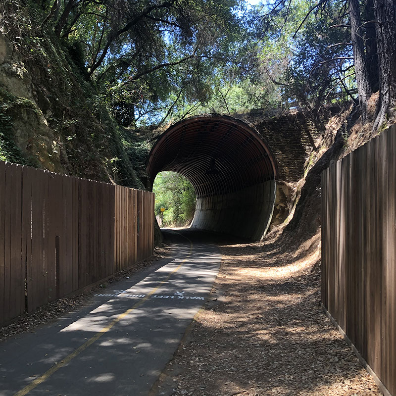
Riding east from Placerville, both routes coincide from Placerville (Mile 2145) to near Five Mile Terrace (around Mile 2138), where they follow the paved Class 1 bike path of the El Dorado Trail. This is a steady uphill grade (3% by ridewithgps), the kind of climb you might imagine as appropriate for a railroad. The two trails split where the pavement ends, which is at Halcon Road (between Miles 2137 and 2138 on the PX Bikepacking Route. As I was following the PX Route eastbound, I continued across this street to follow the Route for another mile and a half where it was supposed to cross US 50.

Unfortunately, all I found at the end was a dead end, a chainlink fence, and a rather steep embankment leading up to US 50. After searching for a short while, I couldn't find any way to continue on the PX Route. So I backtracked to Halcon Road and followed the 2017 Centennial Route. This led to a crossing of US 50 about a mile west of where the PX Route crosses it. Once across, I followed the 2017 Route to Carson Road, which reconnects with the PX Route about one mile east where the PX Route leaves Carson Road to cross US 50.
Needless to say, the PX Route needs to be updated to reflect this info. contacted Jan and sent her pictures, routes, etc. I am certain there will be a revision soon.
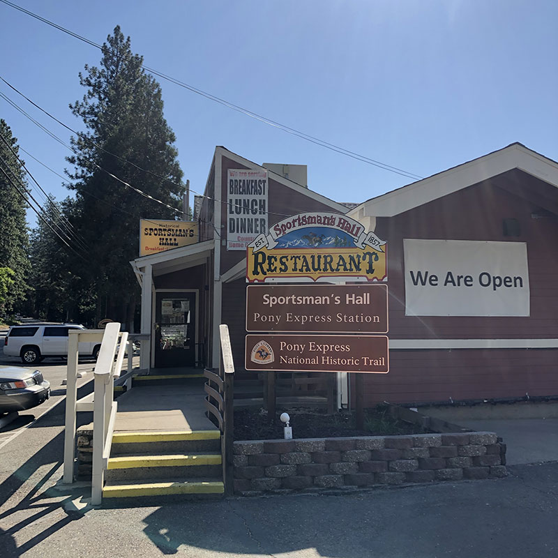
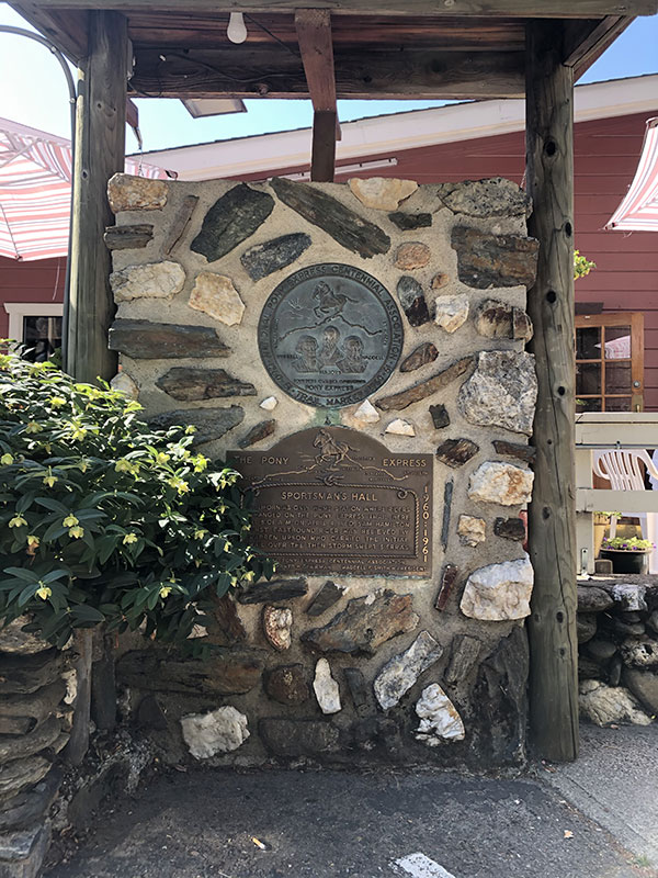
The rest of the eastbound leg to Pollock Pines is on a two-lane that runs roughly alongside US 50. The shoulder is narrow, sometimes only dirt, sometimes disappearing altogether on curves. Not my favorite type of riding. On the other hand, the speed limit is 45, and slows to 25 for the (cute) town of Camino along the way. It also passes by Sportsman's Hall, the only Home station (where a new rider took over) on the Pony Express in California. So all things considered, not too bad.
Westbound
After a short break in Pollock Pines, I headed back to Placerville on the 2017 Centennial Route. This route follows along the banks of an irrigation ditch from Pollock Pines to just east of Sportsman's Hall. I had a hard time finding the trail, and once I found it, an even harder time staying on it. On the east end, the trail starts as a singletrack off Forebay Road. It's very easy to miss. After a couple of hundred yards, the trail opens into a wide flatland on the south side of Forebay Lake. There is a wide road that continues up a hill to the left, so I took it. It dead ends into a locked gate a mile or so up at Drop Off Road. A friendly local told me how to find the road that runs alongside the lake. So I found that and backtracked to see where I went wrong. Back in the clearing, I saw there were two roads: the wide one to the left, which I took, and a narrower one to the right, which I had just returned on.

FWIW, my ride map has links to pictures at the various trouble spots. And in the slideshow on that page, I commented on the pictures to try to explain what they were attempting to show.
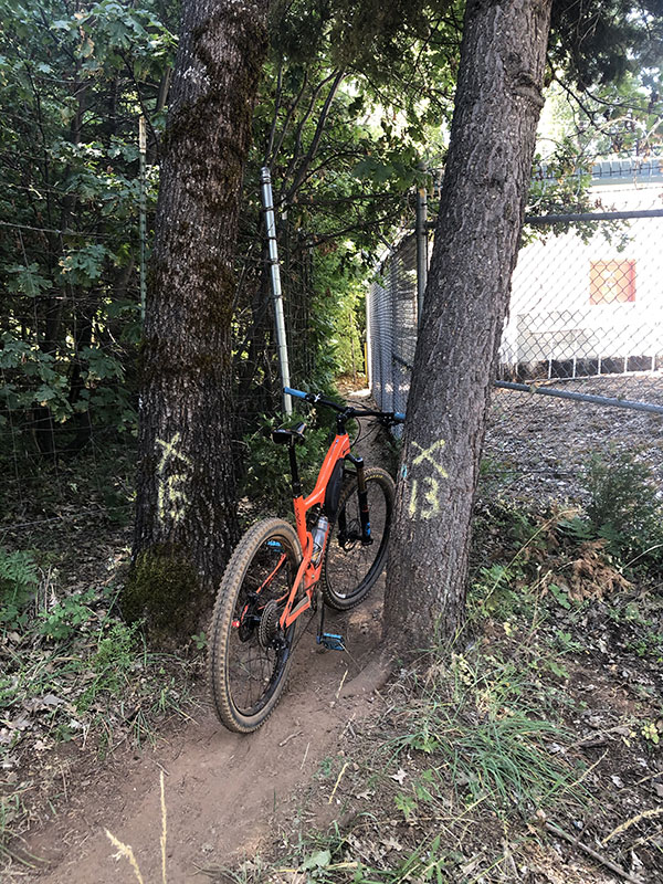
I followed the lake trail for a short time until I came to a landscape project. The trail ended and there was landscape netting, apparently recently installed, or still in the process. I hiked to the top of the construction area and searched all over for the continuation of the trail. I couldn't find it, so I took the only viable trail I could see. I probably spent thirty minutes or more walking this trail (through poison oak) and up and down the hill. Finally, I came to a roped off overgrown road that promised a locked gate at the end (but did not say Private Property or No Trespassing). I followed that, found a gap between the fence and gate, and ended up on Pinewood Lane, which, happily, led down to the irrigation canal and its adjacent trail.
As before, I backtracked along the trail to see if I could connect it with the part of the trail prior to the landscape construction. Nothing doing. The trail starts from the lake by a spillway and is heavily protected by fencing. If the roadside trail ever connected to the irrigation ditch trail, there is a section missing in the middle and I don't see any way to connect the two. I will have to go back and see if there is a viable way (i.e., a not trespassing route) through the neighborhood to get to the irrigation canal at Pinewood Lane.
Once on the ditch trail, and riding in the right direction, I had a very pleasant ride. The ditch flows calmly, there is a wonderful canopy of firs and cedars. It is a slow ride–not something to do if you're trying to pack in a hundred-mile day–but very pleasant.
Toward the west end of the ditch is a collection area of sorts, again, heavily protected by gates. Just before this are, you have to cross the canal and ride on its east bank. The passage along the buildings by the collection area is short, but extremely narrow, squeezed between buildings and a fence. Ther was not enough width for me to walk alongside my bike.
Soon after leaving the irrigation canal, the route puts you back on Pony Express Trail just east of Sportsman's Hall. This is the same road the PX Bikepacking Route follows. About one mile further west, though, the 2017 Route turns off Pony Express Trail and heads onto the smaller roads just north of the main road. These are pleasant, less travelled. The only downside is that the Pony Express Trail is a steady downhill from Pollock Pines toward Placerville. the side roads take by the 2017 Centennial Route have climbs and descents, as well as a short dirt section (on Happy Hollow Lane), and so, is the slower of the two. The tradeoff is faster speed and slightly shorter distance (PX Route) or less traffic, more hills, and a longer riding time (2017 Centennial Route).
The 2017 Centennial Route rejoins the PX Bikepacking Route on Carson Road right at the point the (current) PX Route tells you to cross US 50. As discussed earlier, this isn't a viable crossing. Rather, you need to continue another mile down Carson Road and cross US 50 there, then find your way back to the El Dorado Trail where the paved portion starts off Halcon Road. Presumably, this will be updated on the official PX Bikepacking Route map soon.
More Pictures from the ride: