I haven't been able to ride the last few weeks due to the fires and quality of the air in California. The national forests, including Eldorado Forest, through which the Pony Express runs, are completely closed to all visitors. So I drove out to Austin, Nevada earlier this week (9/13-15/2020) planning to ride the trail between Dry Creek Station in the east to Simpson Park Station (I posted a little about Ausin here. The Pony Express Bikepacking Trail does not run between these two stations, instead avoiding both. I wanted to see if there was a viable route here.
As it turned out, I was only able to scout a couple of access routes to Simpson Park from the west.
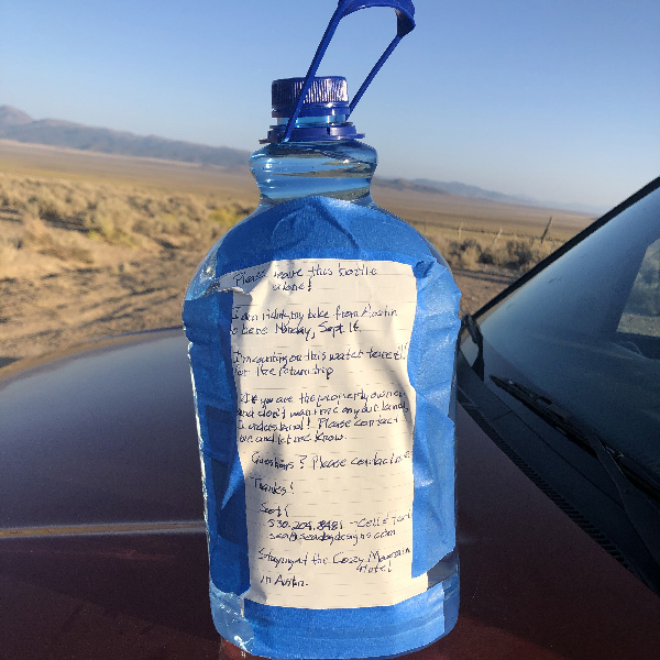
Part of the issue was that I freaked myself out about the remoteness of this part of the trail. So freaked out, I mapped out three routes using Topo, ESRI Topo, and Satellite view maps as bases. Also, I was concerned that the ride was an out-and-back for a total of about 32 miles with no water at either end. I partially solved this dilemma by driving out to Dry Creek Station the day earlier and dropping of a gallon of water by a fence by a gate on the trail—a sixty-mile round trip by car. Of course, I couldn't guarantee it would still be there the next day, but I felt fairly certain no one else wold pass that way in the meantime.
Another part of the issue is that I was kept up until 5am by construction workers partying at the motel where I was staying in Austin. It turns out that the three motels in Austin are largely occupied throughout the summer by construction crews. This particular crew were a subterranean crew that worked the night shift—5pm to 5am— and the afternoon I arrived, Sunday, was their one night off.
By the time I got a little sleep and my headache subsided, I wasn't at the trail start until 10:30. It seemed too late at that point to ride to Dry Creek and back, so I set about trying to find a route to Simpson Park Station. The station lies about three miles west of Grass Valley Road, so I parked there and explored the possibilities.
Wolf Ranch
I first tried from the southernmost of the possible routes. This route leaves Grass Valley Road on Forest Road 43225 (https://goo.gl/maps/Mgkt1E73kq1CRFBF9) and merges with Forest Road 43228 near the site of Simpson Park Station (located at https://goo.gl/maps/E9LRywubFDG5L8Md7).
There was a mailbox for Wolf Ranch and entrance had a No Trespassing sign. I had communicated with someone from the Bureau of Land Management who told my that it was okay to ride on public roads through private land. So I rode on for about a mile, past the empty ranch house, made a wrong turn, got back on track and . . . ran straight into a fence barring further access along the Forest Road. Not a gate, a fence. So, dead end. You can see my track at https://ridewithgps.com/trips/56165900.
Thorp Canyon
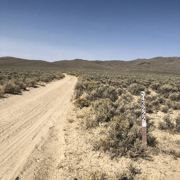
A little further up Grass Valley Road the area is labelled "Thorp Canyon." A file I received from the BLM indicates the east/west path at this point as being the Pony Express Trail. To the west of Grass Valley Road, it is indicated as Park Service Road 43222, and from this point west is the track the XP Bikepacking Route follows (the spot is located at https://goo.gl/maps/gidNrTaEgTeDHaV7A). There is no indicator leading east, though there is a de-signed sign post.
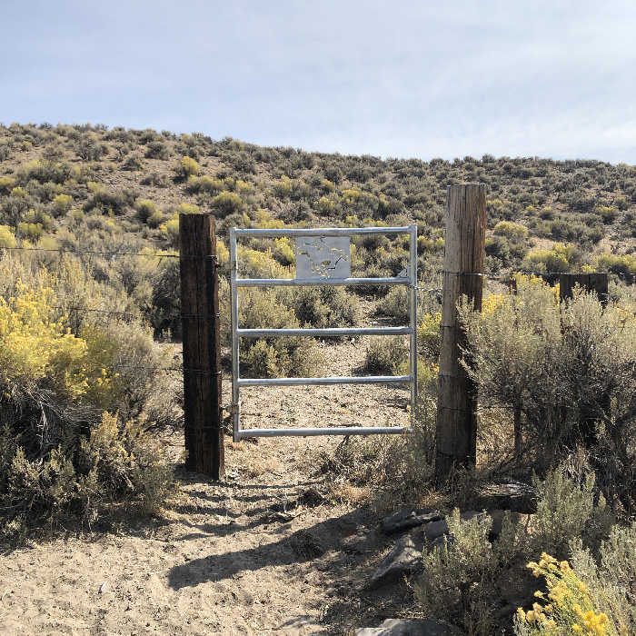
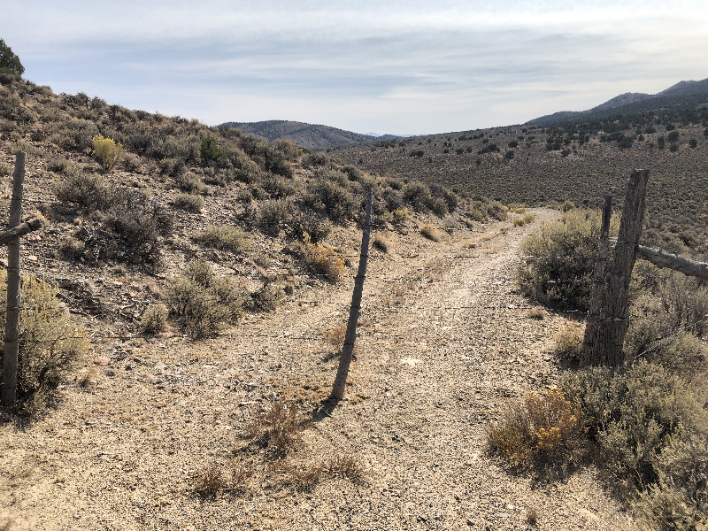
The road east here follows a fence. About 3/4 of a mile in there is a marker designating the Overland Trail which ran through here, part of the trail surveyed by the eponymous Captain Simpson in 1859. In any case, a little further on, the trail dead-ends into a gate. This gate was installed and is maintained by the National Pony Express Association. I emailed with one of their local members who alluded to the gate, though not its location. Once he found out I was riding a bike, and not a horse, he stopped responding to my emails. So when I saw the new-ish gate with the XP Logo on it, I knew I had found his secret access. Well, not so secret; this is not the only access to the XP Trail along this stretch. He just told me it cut about a mile off the ride, so I know there was an alternative if I couldn't get past this point.
And sure enough, the gate was locked. I was about to give up and turn around, but happily, I tested the lock, and it was closed, but not completely locked, so it opened. I went through, closed it again, then just as quickly found I was lost. I couldn't find a trail on the other side of the fence. The entire area is clumped with greasewood up to about 3 feet high, and there is no clear path through it. Just east, the land rose to a ridge, so I hiked up see if a bird's-eye view might help. Not only did it not help, but I couldn't even see my bike in the greasewood. I hiked back down, found the bike, and wondered for a moment what to do.
Then it hit me. All along the trail to the fence I had been dodging horse poop. I looked around, and sure enough, there was horse poop everywhere. So instead of a trail of dirt, I wound through the bushes looking for poop. After some slow going and lots of scratches, there was another de-signed signpost at the base of a narrow trail next to a small gully leading up to the short ridge. I followed that to the top, crossed about 20 yards of open land, and found a two-track road. I was back on the trail. I turned right, and about two miles later, found what I thought was Simpson Park station. You can see my track at https://ridewithgps.com/trips/56165905.
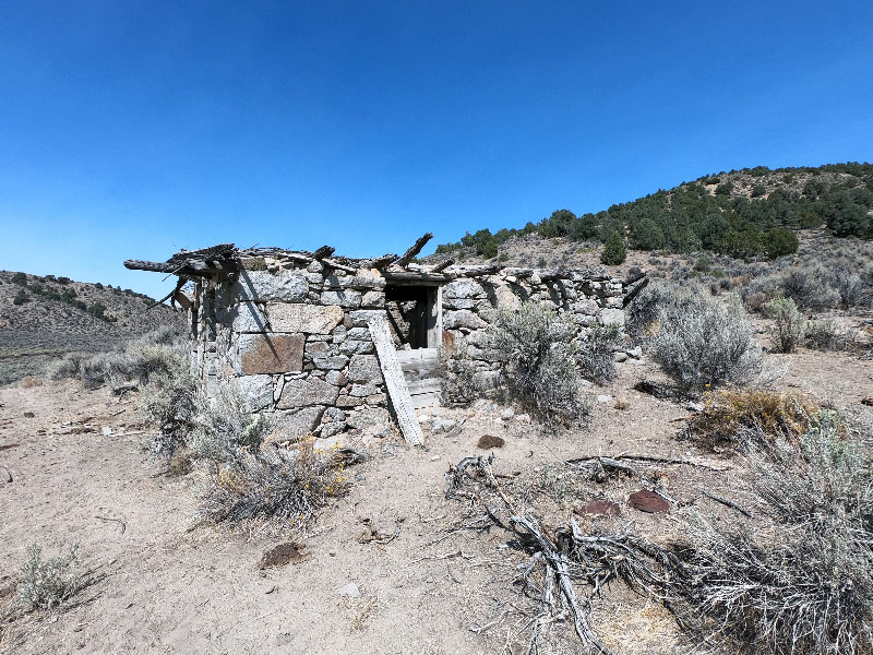
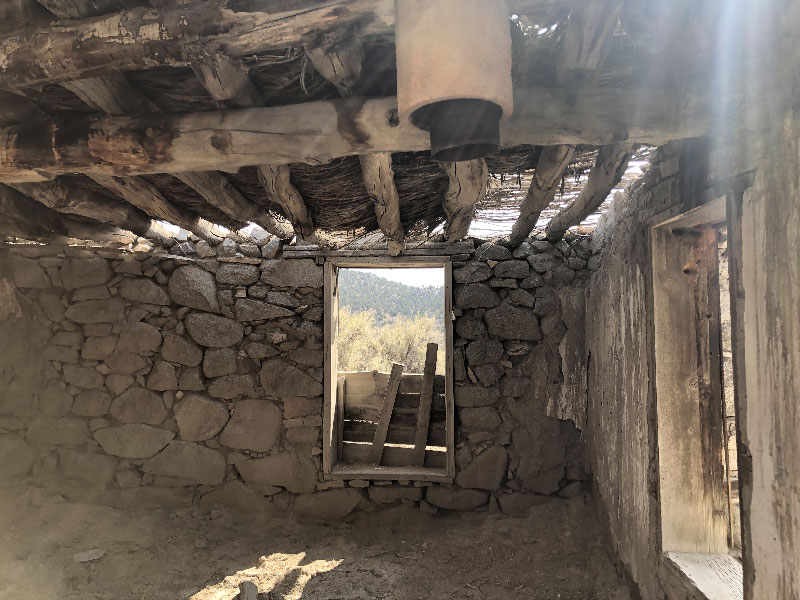
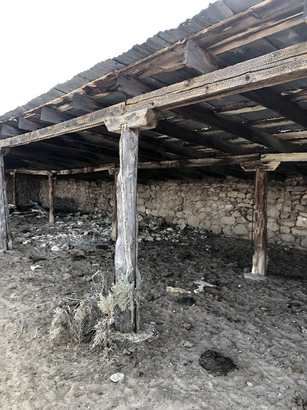
Simpson Park Station
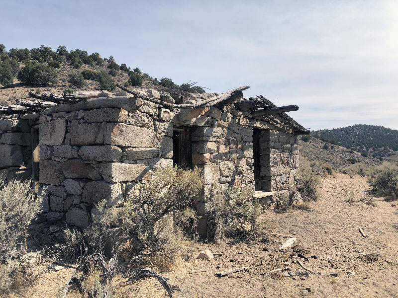
The building I found is not in great repair, but what's there is well worth seeing. The stonework walls are beautiful. There is a small corral nearby. I stayed here for some time, taking a snack break, and wondering how god-awful lonely this place must have been in Pony Express days. I was so excited to find the structure that I assumed it was Simpson Park Station. On later research, I found the station site is about a mile northwest on the Wolf Ranch property. I don't know if it's accessible, and I rather doubt it. I hope to find out on another trip.
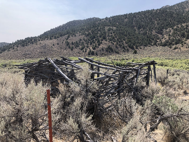
Willow Creek Ranch
On the way back, I noticed another type of trail marker. The trail here follows around the base of the hills, and little way up the ill at intervals you can see solitary branches, stripped and burned, and planted facing upward. Almost like fenceposts, though much further apart. They act like channel markings, indicating the direction of the path, though not immediately next to it. Once I noticed them, it was fun imagining a time before the road was a two-track and these signs were the primary indicators of the trail.
I rode past the NPEA gate and kept on the double-track (Forest Service Road 43228), which topo maps showed me led out to Grass Valley Road further up. I assumed this would be the extra mile or so the NPEA folks cut out by installing that gate. This Forest Service Road, like the one at Wolf Ranch, is fenced off at one point. Unlike Wolf Ranch, however, the double-track turns to follow the fence. So I kept on until I came to an area that looked like it was getting close to some trailers and other habitations. Not wanting to encroach, I turned back.
But rather than ride all the way back to the narrow trail to the ridge, and on the flats through trackless greasewood, I rode to a spot on the ridge just opposite the NPEA gate and rode straight down the small hill. This might be difficult to climb, but was an easy enough descent. And a lot less scratchy on the legs.
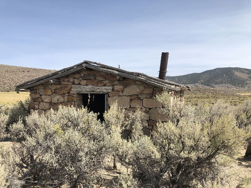
Back in the car, I drove to where Forest Road 43228 hits Grass Valley, which is indicated on topo maps as Willow Creek Ranch. There are some decently preserved building here, again, worth seeing if you're into that kind of thing. I followed this road down about a quarter of a mile, and once again, ran into a gate. This gate, however, is just chained with a loose nut and bolt. From where I stood, I could see the point to which I had ridden when returning from Simpson Park Station. So this, then, may be the best route, at least for those who don't want to much around following horse-poop tracks through tangles of greasewood bushes. You can see my track at https://ridewithgps.com/trips/56165909.
Follow Up
As I said earlier, I hope to go back and actually make the entire ride from Grass Valley Road to Dry Creek and back.Snow starts early in this area, so we'll see if I can get back in time. It also looks like there might be one more path to try a little further up Grass Valley Road, so I might try to scout that as well. Once I do, I'll map all of this out with photos and comments.